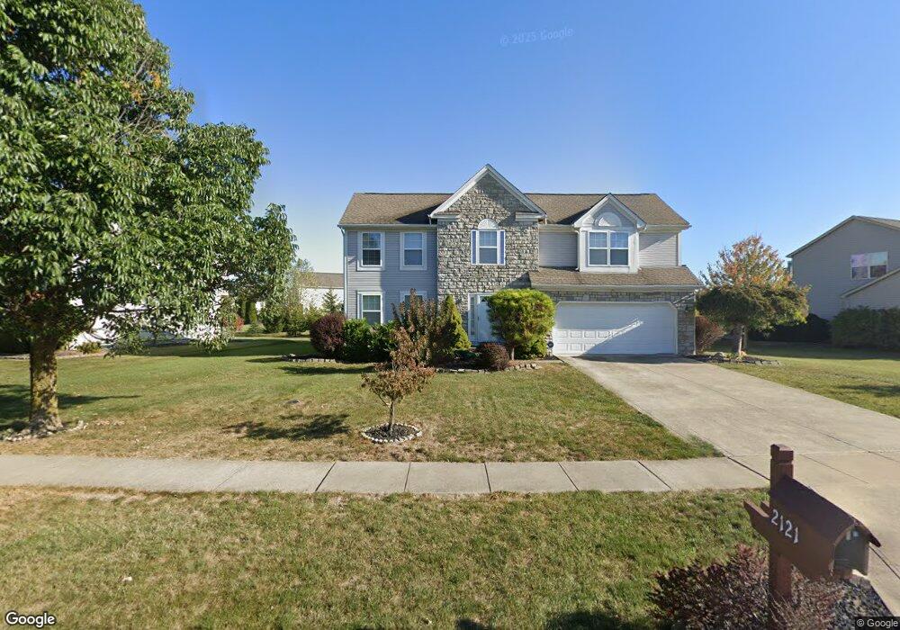
2121 Maxwell Ave Lewis Center, OH 43035
Orange NeighborhoodEstimated Value: $501,602 - $531,000
4
Beds
3
Baths
2,600
Sq Ft
$199/Sq Ft
Est. Value
About This Home
This home is located at 2121 Maxwell Ave, Lewis Center, OH 43035 and is currently estimated at $516,901, approximately $198 per square foot. 2121 Maxwell Ave is a home located in Delaware County with nearby schools including Freedom Trail Elementary School, Olentangy Orange Middle School, and Orange High School.
Ownership History
Date
Name
Owned For
Owner Type
Purchase Details
Closed on
Jan 3, 2020
Sold by
Lam Hung Si and Yeung Yuet Sim Lam Au
Bought by
Lam Hiu Chun
Current Estimated Value
Purchase Details
Closed on
Aug 22, 2008
Sold by
Tong Chai K and Tong Vily Suryani
Bought by
Lam Hiu Chun and Si Lam Hung
Home Financials for this Owner
Home Financials are based on the most recent Mortgage that was taken out on this home.
Original Mortgage
$197,600
Outstanding Balance
$129,563
Interest Rate
6.31%
Mortgage Type
Purchase Money Mortgage
Estimated Equity
$387,338
Purchase Details
Closed on
Jan 3, 2002
Sold by
Rockford Homes Inc
Bought by
Suryani Chai K Tong Vily
Home Financials for this Owner
Home Financials are based on the most recent Mortgage that was taken out on this home.
Original Mortgage
$217,500
Interest Rate
6.87%
Mortgage Type
New Conventional
Create a Home Valuation Report for This Property
The Home Valuation Report is an in-depth analysis detailing your home's value as well as a comparison with similar homes in the area
Home Values in the Area
Average Home Value in this Area
Purchase History
| Date | Buyer | Sale Price | Title Company |
|---|---|---|---|
| Lam Hiu Chun | -- | Accommodation | |
| Lam Hiu Chun | $247,000 | Talon Group | |
| Suryani Chai K Tong Vily | $224,295 | -- |
Source: Public Records
Mortgage History
| Date | Status | Borrower | Loan Amount |
|---|---|---|---|
| Open | Lam Hiu Chun | $197,600 | |
| Closed | Suryani Chai K Tong Vily | $217,500 |
Source: Public Records
Tax History
| Year | Tax Paid | Tax Assessment Tax Assessment Total Assessment is a certain percentage of the fair market value that is determined by local assessors to be the total taxable value of land and additions on the property. | Land | Improvement |
|---|---|---|---|---|
| 2024 | $7,673 | $138,670 | $34,300 | $104,370 |
| 2023 | $7,701 | $138,670 | $34,300 | $104,370 |
| 2022 | $7,141 | $104,550 | $24,150 | $80,400 |
| 2021 | $7,181 | $104,550 | $24,150 | $80,400 |
| 2020 | $6,613 | $104,550 | $24,150 | $80,400 |
| 2019 | $5,593 | $92,790 | $21,000 | $71,790 |
| 2018 | $5,615 | $92,790 | $21,000 | $71,790 |
| 2017 | $5,788 | $83,900 | $16,140 | $67,760 |
| 2016 | $5,966 | $83,900 | $16,140 | $67,760 |
| 2015 | $5,445 | $83,900 | $16,140 | $67,760 |
| 2014 | $5,522 | $83,900 | $16,140 | $67,760 |
| 2013 | $5,475 | $81,310 | $16,140 | $65,170 |
Source: Public Records
Map
Nearby Homes
- 1923 Myrtle St
- 1746 E Powell Rd
- 7631 Pleasant Colony Ct
- 7616 Affirmed Ct
- 2589 Aikin Cir S
- 7485 Bold Venture Ct
- 1143 Little Bear Place
- 9194 Gramford St Unit 9194
- 9246 Windy Creek Dr
- 2849 Pleasantdale Dr
- 1047 Stone Ring Ct
- 2715 Tucker Trail
- 9105 Misty Dawn Dr
- 2375 Cross Creek Ct
- 1328 Royal Oak Dr
- 9136 Scenic View Cir
- 1129 Pebble Brook Dr
- 2935 Laura Place
- 1365 Briarshore Way
- 0 E Orange Rd Unit lot 1
- 2101 Maxwell Ave
- 2145 Maxwell Ave
- 2166 Barnet Ct
- 2093 Maxwell Ave
- 2163 Maxwell Ave
- 2182 Barnet Ct
- 2110 Maxwell Ave
- 2161 Barnet Ct
- 2132 Maxwell Ave
- 2122 Maxwell Ave
- 2100 Maxwell Ave
- 2148 Maxwell Ave
- 2083 Maxwell Ave
- 2181 Maxwell Ave
- 2094 Maxwell Ave
- 2166 Maxwell Ave
- 2200 Barnet Ct
- 2167 Barnet Ct
- 2088 Maxwell Ave
- 2075 Maxwell Ave
Your Personal Tour Guide
Ask me questions while you tour the home.