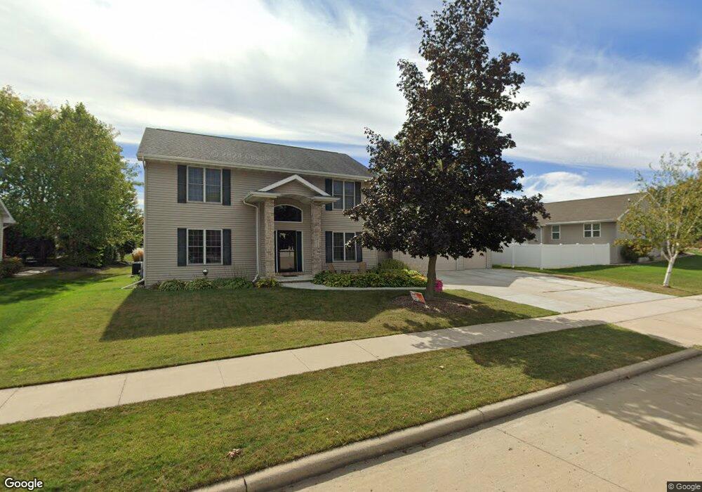
213 Deforest Dr Kaukauna, WI 54130
Estimated Value: $431,126 - $521,000
4
Beds
3
Baths
1,264
Sq Ft
$367/Sq Ft
Est. Value
About This Home
This home is located at 213 Deforest Dr, Kaukauna, WI 54130 and is currently estimated at $464,032, approximately $367 per square foot. 213 Deforest Dr is a home located in Outagamie County with nearby schools including River View School, Kaukauna High School, and New Directions Learning Community.
Ownership History
Date
Name
Owned For
Owner Type
Purchase Details
Closed on
Apr 18, 2008
Sold by
Randall Timothy J and Randall Mary M
Bought by
Geoffrey James M and Geoffrey Diana L
Current Estimated Value
Purchase Details
Closed on
Aug 1, 2005
Sold by
Jon Huss Construction Corp
Bought by
Randall Timothy J and Randall Mary M
Purchase Details
Closed on
Jul 28, 2005
Sold by
Fieldcrest Developers Llp
Bought by
Jon Huss Construction Corp
Create a Home Valuation Report for This Property
The Home Valuation Report is an in-depth analysis detailing your home's value as well as a comparison with similar homes in the area
Home Values in the Area
Average Home Value in this Area
Purchase History
| Date | Buyer | Sale Price | Title Company |
|---|---|---|---|
| Geoffrey James M | $216,500 | -- | |
| Randall Timothy J | $222,400 | -- | |
| Jon Huss Construction Corp | $37,900 | -- |
Source: Public Records
Tax History
| Year | Tax Paid | Tax Assessment Tax Assessment Total Assessment is a certain percentage of the fair market value that is determined by local assessors to be the total taxable value of land and additions on the property. | Land | Improvement |
|---|---|---|---|---|
| 2023 | $5,648 | $291,700 | $40,000 | $251,700 |
| 2022 | $5,272 | $291,700 | $40,000 | $251,700 |
| 2021 | $5,018 | $291,700 | $40,000 | $251,700 |
| 2020 | $4,895 | $217,800 | $33,100 | $184,700 |
| 2019 | $4,896 | $217,800 | $33,100 | $184,700 |
| 2018 | $5,167 | $217,800 | $33,100 | $184,700 |
| 2017 | $5,394 | $217,800 | $33,100 | $184,700 |
| 2016 | $5,172 | $217,800 | $33,100 | $184,700 |
| 2015 | $5,199 | $217,800 | $33,100 | $184,700 |
| 2014 | $5,190 | $217,800 | $33,100 | $184,700 |
| 2013 | $5,235 | $217,800 | $33,100 | $184,700 |
Source: Public Records
Map
Nearby Homes
- 230 Deforest Dr
- 4110 Ridgecrest Ln
- 2505 Laverne Ln
- 1712 Thelen Ave
- 525 E 20th St
- 103 Green Way Dr
- 1000 Main Ave
- 535 Coonen Dr
- 1501 Oakridge Ave
- 126 W 14th St
- 114 Shalimar Ct
- 657 Hideaway Ct
- 101 Ombre Rose Dr
- W2286 Valleywood Ln
- 109 E 11th St
- 428 W 10th St
- 426 W 10th St
- 1831 White Dove Ln
- N274 Mueller Ct
- 1349 Edgewood Dr
- 3100 Shady Ridge Ln
- 212 Spring Ridge Dr
- 208 Spring Ridge Dr
- 3022 Shady Ridge Ln
- 201 Deforest Dr
- 212 Deforest Dr
- 208 Deforest Dr
- 200 Spring Ridge Dr
- 3201 Shadey Ridge Ln
- 3123 Shadey Ridge Ln
- 200 Deforest Dr
- 3101 Tranquil Way
- 3101 Shady Ridge Ln
- 146 Spring Ridge Dr
- 3051 Shady Ridge Ln
- 3005 Shady Ridge Ln
- 146 Deforest Dr
- 213 Spring Ridge Dr
- 209 W Morningside Dr
- 223 W Morningside Dr
Your Personal Tour Guide
Ask me questions while you tour the home.