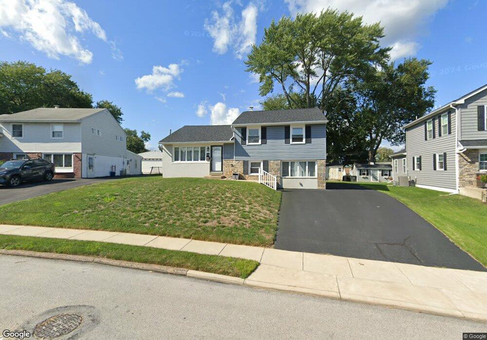
214 Durley Dr Broomall, PA 19008
Estimated Value: $455,000 - $531,000
3
Beds
2
Baths
1,520
Sq Ft
$319/Sq Ft
Est. Value
About This Home
This home is located at 214 Durley Dr, Broomall, PA 19008 and is currently estimated at $484,552, approximately $318 per square foot. 214 Durley Dr is a home located in Delaware County with nearby schools including Loomis Elementary School, Paxon Hollow Middle School, and Marple Newtown Senior High School.
Ownership History
Date
Name
Owned For
Owner Type
Purchase Details
Closed on
Jan 7, 2021
Sold by
Yost Michael J
Bought by
Kuip David
Current Estimated Value
Home Financials for this Owner
Home Financials are based on the most recent Mortgage that was taken out on this home.
Original Mortgage
$315,000
Outstanding Balance
$281,139
Interest Rate
2.71%
Mortgage Type
VA
Estimated Equity
$203,413
Purchase Details
Closed on
Dec 27, 2019
Sold by
Kulp Joseph Walter and Estate Of Concetta Kulp
Bought by
Yost Michael J
Home Financials for this Owner
Home Financials are based on the most recent Mortgage that was taken out on this home.
Original Mortgage
$218,500
Interest Rate
3.6%
Mortgage Type
New Conventional
Purchase Details
Closed on
Oct 14, 1980
Sold by
Kulp Jos and Kulp Concetta
Bought by
Kulp Concetta
Create a Home Valuation Report for This Property
The Home Valuation Report is an in-depth analysis detailing your home's value as well as a comparison with similar homes in the area
Home Values in the Area
Average Home Value in this Area
Purchase History
| Date | Buyer | Sale Price | Title Company |
|---|---|---|---|
| Kuip David | $315,000 | Homestead Abstract Setmnt Sv | |
| Yost Michael J | $230,000 | Homestead Abstract Setmnt Sv | |
| Kulp Concetta | -- | -- |
Source: Public Records
Mortgage History
| Date | Status | Borrower | Loan Amount |
|---|---|---|---|
| Open | Kuip David | $315,000 | |
| Previous Owner | Yost Michael J | $218,500 |
Source: Public Records
Tax History
| Year | Tax Paid | Tax Assessment Tax Assessment Total Assessment is a certain percentage of the fair market value that is determined by local assessors to be the total taxable value of land and additions on the property. | Land | Improvement |
|---|---|---|---|---|
| 2025 | $5,231 | $302,700 | $103,120 | $199,580 |
| 2024 | $5,231 | $302,700 | $103,120 | $199,580 |
| 2023 | $5,065 | $302,700 | $103,120 | $199,580 |
| 2022 | $4,969 | $302,700 | $103,120 | $199,580 |
| 2021 | $7,499 | $302,700 | $103,120 | $199,580 |
| 2020 | $4,449 | $154,600 | $53,820 | $100,780 |
| 2019 | $4,395 | $154,600 | $53,820 | $100,780 |
| 2018 | $4,350 | $154,600 | $0 | $0 |
| 2017 | $4,352 | $154,600 | $0 | $0 |
| 2016 | $848 | $154,600 | $0 | $0 |
| 2015 | $866 | $154,600 | $0 | $0 |
| 2014 | $866 | $154,600 | $0 | $0 |
Source: Public Records
Map
Nearby Homes
- 41 Dorset Dr
- 215 Canford Dr
- 12 Cheshire Cir
- 514 S Central Blvd
- 1 Lawrence Rd Unit G2B
- 349 Glen Gary Dr
- 234 Talbot Dr
- 407 S Central Blvd
- 314 Walnut Hill Ln
- 14 Vassar Rd
- 649 Glendale Rd
- 400 Glendale Rd Unit A 54
- 400 Glendale Rd Unit H32
- 400 Glendale Rd Unit F35
- 400 Glendale Rd Unit E34
- 206 Oxford Hill Ln
- 508 Circle Dr
- 126 Ivy Rock Ln
- 505 Glendale Rd
- 2203 Clover Dr
- 212 Durley Dr
- 216 Durley Dr
- 205 Cranbourne Dr
- 207 Cranbourne Dr
- 210 Durley Dr
- 203 Cranbourne Dr
- 218 Durley Dr
- 209 Cranbourne Dr
- 215 Durley Dr
- 213 Durley Dr
- 201 Cranbourne Dr
- 208 Durley Dr
- 211 Cranbourne Dr
- 211 Durley Dr
- 220 Durley Dr
- 219 Durley Dr
- 199 Cranbourne Dr
- 215 Cranbourne Dr
- 209 Durley Dr
- 206 Durley Dr
Your Personal Tour Guide
Ask me questions while you tour the home.