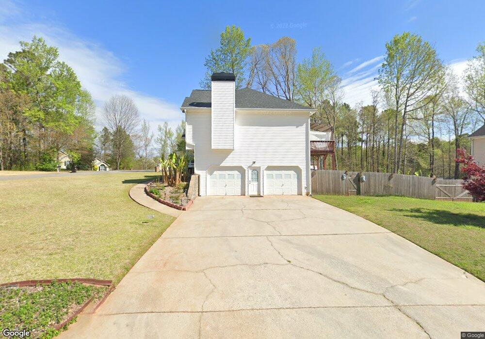
215 Sable Trace Dr Acworth, GA 30102
Oak Grove NeighborhoodEstimated Value: $394,000 - $415,069
About This Home
This home is located at 215 Sable Trace Dr, Acworth, GA 30102 and is currently estimated at $404,535, approximately $174 per square foot. 215 Sable Trace Dr is a home located in Cherokee County with nearby schools including Oak Grove Elementary School, E. T. Booth Middle School, and Etowah High School.
Ownership History
We collect this data history from publicly available records. To have your information removed, we recommend requesting removal directly through your county’s website.
Purchase Details
Home Financials for this Owner
Home Financials are based on the most recent Mortgage that was taken out on this home.Purchase Details
Home Financials for this Owner
Home Financials are based on the most recent Mortgage that was taken out on this home.Home Values in the Area
Average Home Value in this Area
Purchase History
We collect this data history from publicly available records. To have your information removed, we recommend requesting removal directly through your county’s website.
| Date | Buyer | Sale Price | Title Company |
|---|---|---|---|
| $185,500 | -- | ||
| $179,900 | -- |
Mortgage History
We collect this data history from publicly available records. To have your information removed, we recommend requesting removal directly through your county’s website.
| Date | Status | Borrower | Loan Amount |
|---|---|---|---|
| Open | $179,200 | ||
| Previous Owner | $177,100 |
Tax History
We collect this data history from publicly available records. To have your information removed, we recommend requesting removal directly through your county’s website.
| Year | Tax Paid | Tax Assessment Tax Assessment Total Assessment is a certain percentage of the fair market value that is determined by local assessors to be the total taxable value of land and additions on the property. | Land | Improvement |
|---|---|---|---|---|
| 2025 | $3,771 | $162,040 | $34,000 | $128,040 |
| 2024 | $3,763 | $162,956 | $34,000 | $128,956 |
| 2023 | $3,363 | $164,636 | $34,000 | $130,636 |
| 2022 | $3,230 | $135,800 | $32,000 | $103,800 |
| 2021 | $2,922 | $110,920 | $24,000 | $86,920 |
| 2020 | $2,757 | $103,680 | $22,000 | $81,680 |
| 2019 | $2,595 | $96,720 | $22,000 | $74,720 |
| 2018 | $2,380 | $86,920 | $19,200 | $67,720 |
| 2017 | $2,372 | $214,500 | $19,200 | $66,600 |
| 2016 | $2,101 | $186,200 | $19,200 | $55,280 |
| 2015 | $1,882 | $165,800 | $15,200 | $51,120 |
| 2014 | $1,839 | $161,800 | $13,000 | $51,720 |
Map
- 585 Lee Dr
- 6390 Woodstock Rd
- 337 Lee Dr
- 306 Queensbury Walk
- 1030 Queensbury Run Unit 1
- 131 Jake Taylor Dr
- 3122 Cambridge Mill St
- 3114 Cambridge Mill St
- 503 Oakleaf Ct
- 728 Coventry Cove Way
- 740 Coventry Cove Way
- 744 Coventry Cove Way
- 3102 Cambridge Mill St
- 305 Brighton Bend Ln
- 309 Brighton Bend Ln
- 333 Brighton Bend Ln
- 422 Royal Oak Dr
- 174 Sable Trace Trail
- 3054 Cambridge Mill St
- 3198 Croftside Commons
- 300 Sable Trace Pass
- 217 Sable Trace Dr
- 708 Sable Trace Dr
- 302 Sable Trace Ct
- 301 Sable Trace Ct Unit 25
- 301 Sable Trace Ct
- 219 Sable Trace Dr
- 226 Sable Trace Dr
- 304 Sable Trace Ct
- 228 Sable Trace Dr
- 224 Sable Trace Dr
- 303 Sable Trace Ct
- 211 Sable Trace Dr
- 116 Sable Trace Ln
- 230 Sable Trace Dr
- 221 Sable Trace Dr
- 114 Sable Trace Ln
- 222 Sable Trace Dr
- 232 Sable Trace Dr
- 110 Sable Trace Ln
Ask me questions while you tour the home.