2150 Ashbury Dr Eugene, OR 97408
Cal Young NeighborhoodEstimated Value: $776,550 - $1,023,000
4
Beds
3
Baths
2,582
Sq Ft
$342/Sq Ft
Est. Value
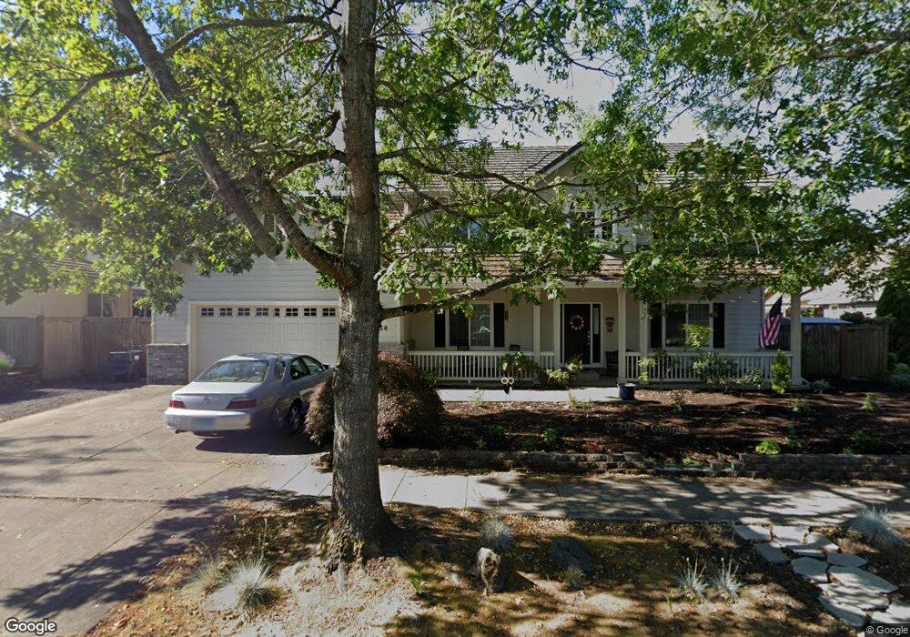
About This Home
This home is located at 2150 Ashbury Dr, Eugene, OR 97408 and is currently estimated at $883,388, approximately $342 per square foot. 2150 Ashbury Dr is a home located in Lane County with nearby schools including Gilham Elementary School, Cal Young Middle School, and Sheldon High School.
Ownership History
Date
Name
Owned For
Owner Type
Purchase Details
Closed on
Aug 29, 2001
Sold by
Hidden Creek Development Llc
Bought by
Peterson Leif W and Peterson Cynthia K
Current Estimated Value
Home Financials for this Owner
Home Financials are based on the most recent Mortgage that was taken out on this home.
Original Mortgage
$125,500
Outstanding Balance
$52,693
Interest Rate
7.09%
Estimated Equity
$830,695
Create a Home Valuation Report for This Property
The Home Valuation Report is an in-depth analysis detailing your home's value as well as a comparison with similar homes in the area
Home Values in the Area
Average Home Value in this Area
Purchase History
| Date | Buyer | Sale Price | Title Company |
|---|---|---|---|
| Peterson Leif W | $54,900 | Evergreen Land Title Co |
Source: Public Records
Mortgage History
| Date | Status | Borrower | Loan Amount |
|---|---|---|---|
| Open | Peterson Leif W | $125,500 |
Source: Public Records
Tax History
| Year | Tax Paid | Tax Assessment Tax Assessment Total Assessment is a certain percentage of the fair market value that is determined by local assessors to be the total taxable value of land and additions on the property. | Land | Improvement |
|---|---|---|---|---|
| 2025 | $9,117 | $467,916 | -- | -- |
| 2024 | $9,003 | $454,288 | -- | -- |
| 2023 | $9,003 | $441,057 | $0 | $0 |
| 2022 | $8,435 | $428,211 | $0 | $0 |
| 2021 | $7,922 | $415,739 | $0 | $0 |
| 2020 | $7,950 | $403,631 | $0 | $0 |
| 2019 | $7,678 | $391,875 | $0 | $0 |
| 2018 | $7,227 | $369,381 | $0 | $0 |
| 2017 | $6,886 | $369,381 | $0 | $0 |
| 2016 | $6,622 | $358,622 | $0 | $0 |
| 2015 | $6,424 | $348,177 | $0 | $0 |
| 2014 | $6,345 | $338,036 | $0 | $0 |
Source: Public Records
Map
Nearby Homes
- 2183 Ashbury Dr
- 3540 Walton Ln
- 3620 Walton Ln
- 2225 Avengale Dr
- 3689 Marcella Dr
- 2063 Lake Wind Dr
- 2138 Country Haven Dr
- 2251 Lathen Way
- 2099 Lake Shore Dr
- 3335 Lake Glenn Dr
- 1930 Sterling Park Place
- 1880 Lake Cove Ave
- 2072 Lakeland Way
- 3921 Heather Grove Ln
- 3328 Lakemont Dr
- 2053 Lakeview Dr
- 3428 River Pointe Dr
- 3435 Meadow View Dr
- 3858 Mirror Pond Way
- 3355 N Delta Hwy Unit SP160
Your Personal Tour Guide
Ask me questions while you tour the home.