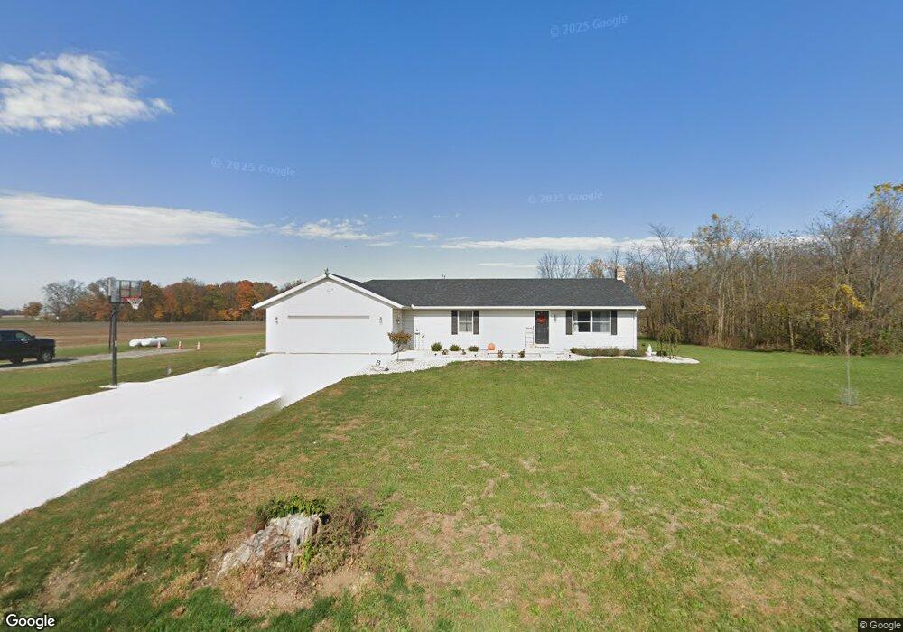
21521 Clay Rd Wapakoneta, OH 45895
Estimated Value: $232,000 - $338,000
2
Beds
2
Baths
1,848
Sq Ft
$148/Sq Ft
Est. Value
About This Home
This home is located at 21521 Clay Rd, Wapakoneta, OH 45895 and is currently estimated at $273,476, approximately $147 per square foot. 21521 Clay Rd is a home located in Auglaize County with nearby schools including Wapakoneta Elementary School, Wapakoneta High School, and Wapakoneta Middle School.
Ownership History
Date
Name
Owned For
Owner Type
Purchase Details
Closed on
Jan 4, 2021
Sold by
Bailey Tyler and Bailey Todd E
Bought by
Bowman Michael D and Bowman Kayla M
Current Estimated Value
Home Financials for this Owner
Home Financials are based on the most recent Mortgage that was taken out on this home.
Original Mortgage
$165,300
Outstanding Balance
$146,487
Interest Rate
2.7%
Mortgage Type
New Conventional
Estimated Equity
$126,989
Purchase Details
Closed on
Dec 31, 2019
Sold by
Regula Marlene and Estate Of Robert E Wildermuth
Bought by
Bailey Tyler and Bailey Todd E
Purchase Details
Closed on
Nov 25, 2002
Sold by
Wildermuth Robert E
Bought by
Wildermuth Robert E
Purchase Details
Closed on
Jun 5, 2002
Sold by
Wildermuth Robert E
Bought by
Wildermuth Robert E
Create a Home Valuation Report for This Property
The Home Valuation Report is an in-depth analysis detailing your home's value as well as a comparison with similar homes in the area
Purchase History
| Date | Buyer | Sale Price | Title Company |
|---|---|---|---|
| Bowman Michael D | $174,000 | Superior Title | |
| Bailey Tyler | $80,000 | None Available | |
| Wildermuth Robert E | -- | -- | |
| Wildermuth Robert E | -- | -- |
Source: Public Records
Mortgage History
| Date | Status | Borrower | Loan Amount |
|---|---|---|---|
| Open | Bowman Michael D | $165,300 |
Source: Public Records
Tax History
| Year | Tax Paid | Tax Assessment Tax Assessment Total Assessment is a certain percentage of the fair market value that is determined by local assessors to be the total taxable value of land and additions on the property. | Land | Improvement |
|---|---|---|---|---|
| 2025 | $2,761 | $54,040 | $9,820 | $44,220 |
| 2024 | $2,761 | $54,040 | $9,820 | $44,220 |
| 2023 | $892 | $54,040 | $9,820 | $44,220 |
| 2022 | $1,654 | $44,600 | $7,860 | $36,740 |
| 2021 | $824 | $44,600 | $7,860 | $36,740 |
| 2020 | $1,632 | $44,601 | $7,858 | $36,743 |
| 2019 | $1,059 | $37,478 | $6,601 | $30,877 |
| 2018 | $1,055 | $37,478 | $6,601 | $30,877 |
| 2017 | $1,049 | $37,478 | $6,601 | $30,877 |
| 2016 | $1,020 | $36,978 | $6,290 | $30,688 |
| 2015 | $1,019 | $36,978 | $6,290 | $30,688 |
| 2014 | $1,030 | $36,978 | $6,290 | $30,688 |
| 2013 | $1,068 | $36,978 | $6,290 | $30,688 |
Source: Public Records
Map
Nearby Homes
- 0 Geyer Dr
- 0 Spring St
- 0 Center St
- 13412 County Road 88
- 20630 State Route 67
- 17 E Walnut St
- 0 Ohio 67
- 21320 Fairmount Rd
- 204 S Westminster St
- 211 E Wapakoneta St
- 105 Guthrie St
- 404 N Westminster St
- 25702 Ohio 67
- 533 N Westminster St
- 101 Sunrise Dr
- 17785 Hengstler Rd
- 116 Village Pkwy
- 11900 Duff Rd Unit 7
- 115 Village Pkwy
- 112 Parkview Dr
- 21325 Clay Rd
- 12600 State Route 65
- 0 Clay Rd Unit 2 278161
- 0 Clay Rd Unit 3 278162
- 12778 State Route 65
- 21929 Clay Rd
- 12218 State Route 65
- 21047 Clay Rd
- 22027 Clay Rd
- 20986 Clay Rd
- 12113 Wrestle Creek Rd
- 11942 State Route 65
- 11997 Ohio 65
- 11997 State Route 65
- 11866 State Route 65
- 20548 Clay Rd
- 13194 State Route 65
- 13194 Ohio 65
- 13111 Wrestle Creek Rd
Your Personal Tour Guide
Ask me questions while you tour the home.