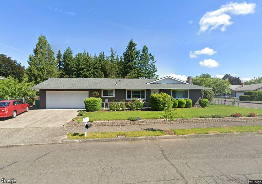
21653 SE Main St Gresham, OR 97030
North Central NeighborhoodEstimated Value: $451,000 - $471,000
3
Beds
3
Baths
1,650
Sq Ft
$279/Sq Ft
Est. Value
About This Home
This home is located at 21653 SE Main St, Gresham, OR 97030 and is currently estimated at $460,497, approximately $279 per square foot. 21653 SE Main St is a home located in Multnomah County with nearby schools including North Gresham Elementary School, Clear Creek Middle School, and Gresham High School.
Ownership History
Date
Name
Owned For
Owner Type
Purchase Details
Closed on
Nov 5, 1999
Sold by
Montgomery Donald R
Bought by
Saeteurn Keui C and Saechao Nai K
Current Estimated Value
Home Financials for this Owner
Home Financials are based on the most recent Mortgage that was taken out on this home.
Original Mortgage
$145,195
Outstanding Balance
$43,573
Interest Rate
7.75%
Mortgage Type
FHA
Estimated Equity
$416,924
Purchase Details
Closed on
Apr 14, 1998
Sold by
Eikenberry Phyllis J
Bought by
Montgomery Donald R
Create a Home Valuation Report for This Property
The Home Valuation Report is an in-depth analysis detailing your home's value as well as a comparison with similar homes in the area
Home Values in the Area
Average Home Value in this Area
Purchase History
| Date | Buyer | Sale Price | Title Company |
|---|---|---|---|
| Saeteurn Keui C | $149,000 | Fidelity National Title Co | |
| Montgomery Donald R | $148,000 | Transnation Title Insurance |
Source: Public Records
Mortgage History
| Date | Status | Borrower | Loan Amount |
|---|---|---|---|
| Open | Saeteurn Keui C | $145,195 |
Source: Public Records
Tax History
| Year | Tax Paid | Tax Assessment Tax Assessment Total Assessment is a certain percentage of the fair market value that is determined by local assessors to be the total taxable value of land and additions on the property. | Land | Improvement |
|---|---|---|---|---|
| 2025 | $5,151 | $253,110 | -- | -- |
| 2024 | $4,930 | $245,740 | -- | -- |
| 2023 | $4,492 | $238,590 | $0 | $0 |
| 2022 | $4,367 | $231,650 | $0 | $0 |
| 2021 | $4,257 | $224,910 | $0 | $0 |
| 2020 | $4,005 | $218,360 | $0 | $0 |
| 2019 | $3,900 | $212,000 | $0 | $0 |
| 2018 | $3,719 | $205,830 | $0 | $0 |
| 2017 | $3,568 | $199,840 | $0 | $0 |
| 2016 | $3,146 | $194,020 | $0 | $0 |
Source: Public Records
Map
Nearby Homes
- 21532 SE Alder St
- 21033 SE Clay Ct
- 1035 SE 225th Ave
- 21400 SE Stark St Unit 2
- 21260 SE Stark St
- 21525 SE Oak St
- 2013 NW Bella Vista Dr
- 21016 SE Stark St Unit 71
- 21016 SE Stark St Unit 69
- 1811 NW 19th St
- 210 SE 218th Ave
- 54 NW 13th St
- 209 SE 214th Ave
- 21553 SE Ankeny Terrace
- 450 NE 22nd St
- 349 NE 18th St
- 132 SE 214th Ave
- 1861 NW Wonderview Ave
- 1783 1791 NE Beech Place
- 1596 NW Riverview Ave
- 1275 SE 217th Ave
- 21641 SE Main St
- 21658 SE Main St
- 1207 SE 217th Ave
- 21644 SE Salmon St
- 2306 NW 217th Ave
- 21644 SE Main St
- 21633 SE Main St
- 2312 NW 217th Ave
- 2246 NW 217th Ave
- 1371 SE 217th Ave
- 21636 SE Salmon St
- 1331 SE 216th Ave
- 2320 NW 217th Ave
- 2234 NW 217th Ave
- 21611 SE Main St
- 1396 SE 216th Ave
- 2317 NW Norman Ave
- 1417 SE 217th Ave
- 21628 SE Salmon St
Your Personal Tour Guide
Ask me questions while you tour the home.