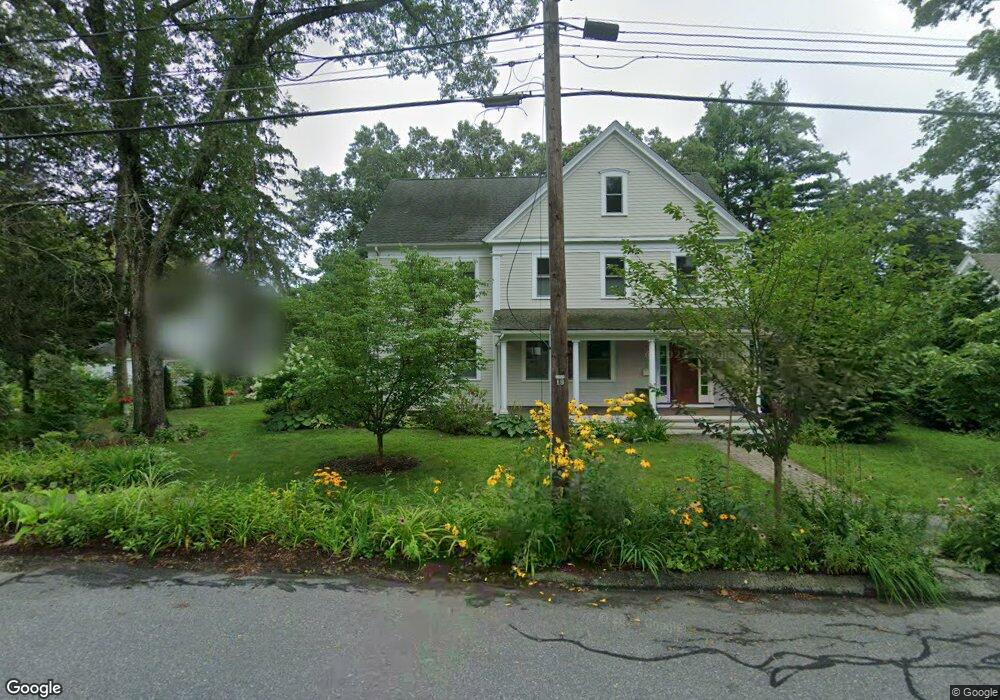
217 Central St Concord, MA 01742
Concord AreaEstimated Value: $1,096,000 - $2,212,000
About This Home
This home is located at 217 Central St, Concord, MA 01742 and is currently estimated at $1,842,485, approximately $1,188 per square foot. 217 Central St is a home located in Middlesex County with nearby schools including Thoreau Elementary School, Concord Middle School, and Concord Carlisle High School.
Ownership History
We collect this data history from publicly available records. To have your information removed, we recommend requesting removal directly through your county’s website.
Purchase Details
Purchase Details
Purchase Details
Home Values in the Area
Average Home Value in this Area
Purchase History
We collect this data history from publicly available records. To have your information removed, we recommend requesting removal directly through your county’s website.
| Date | Buyer | Sale Price | Title Company |
|---|---|---|---|
| $2,125,000 | -- | ||
| $515,000 | -- | ||
| -- | -- |
Mortgage History
We collect this data history from publicly available records. To have your information removed, we recommend requesting removal directly through your county’s website.
| Date | Status | Borrower | Loan Amount |
|---|---|---|---|
| Closed | $408,000 | ||
| Closed | $408,000 |
Tax History
We collect this data history from publicly available records. To have your information removed, we recommend requesting removal directly through your county’s website.
| Year | Tax Paid | Tax Assessment Tax Assessment Total Assessment is a certain percentage of the fair market value that is determined by local assessors to be the total taxable value of land and additions on the property. | Land | Improvement |
|---|---|---|---|---|
| 2025 | $239 | $1,801,100 | $613,700 | $1,187,400 |
| 2024 | $23,580 | $1,795,900 | $613,700 | $1,182,200 |
| 2023 | $19,334 | $1,491,800 | $557,900 | $933,900 |
| 2022 | $19,150 | $1,297,400 | $446,300 | $851,100 |
| 2021 | $18,581 | $1,262,300 | $446,300 | $816,000 |
| 2020 | $18,196 | $1,278,700 | $446,300 | $832,400 |
| 2019 | $16,306 | $1,149,100 | $433,300 | $715,800 |
| 2018 | $16,102 | $1,126,800 | $412,600 | $714,200 |
| 2017 | $15,415 | $1,095,600 | $393,000 | $702,600 |
| 2016 | $15,529 | $1,115,600 | $393,000 | $722,600 |
| 2015 | $14,689 | $1,027,900 | $363,900 | $664,000 |
Map
- 70 McCallar Ln
- 175 Central St
- 102 Highland St
- 189 Conant St Unit U-189
- 51 Damon St
- 32 Bradford St
- 230 Harrington Ave
- 42 Sunnyside Ln
- 132 Cottage St
- 449 Old Marlboro Rd
- 1732 Main St Unit 205
- 297 Laws Brook Rd
- 165 Old Stow Rd
- 14 Concord Greene Unit 8
- 39 Winslow St
- 1814 Main St
- 1832 Main St
- 1844 Main St
- 1844 Main St Unit 1
- 62 Edgewood Rd
- 1443 Main St
- 1453 Main St
- 1431 Main St
- 208 Central St
- 200 Central St
- 200 Central St Unit 2
- 200 Central St Unit 198
- 218 Central St
- 1461 Main St
- 1425 Main St
- 190 Central St
- 224 Central St
- A12 + A13 Lowell Rd
- 1434 Main St
- 118 Highland St
- 1415 Main St
- 18 Central St
- 182 Central St
- 1471 Main St
- 205 Central St
Ask me questions while you tour the home.