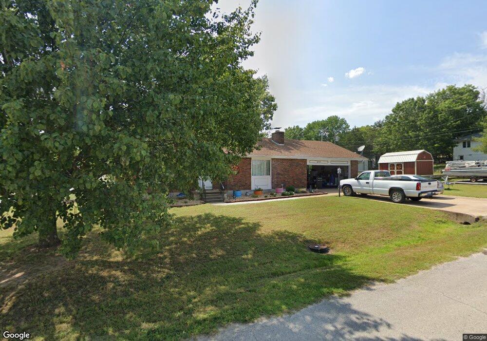
217 Enterprise Ln Branson, MO 65616
Table Rock NeighborhoodEstimated Value: $207,365 - $279,000
About This Home
This home is located at 217 Enterprise Ln, Branson, MO 65616 and is currently estimated at $241,841, approximately $200 per square foot. 217 Enterprise Ln is a home located in Taney County with nearby schools including Cedar Ridge Primary, Cedar Ridge Intermediate School, and Cedar Ridge Elementary School.
Ownership History
We collect this data history from publicly available records. To have your information removed, we recommend requesting removal directly through your county’s website.
Purchase Details
Purchase Details
Purchase Details
Home Values in the Area
Average Home Value in this Area
Purchase History
We collect this data history from publicly available records. To have your information removed, we recommend requesting removal directly through your county’s website.
| Date | Buyer | Sale Price | Title Company |
|---|---|---|---|
| -- | None Available | ||
| -- | Meridian Title | ||
| -- | -- |
Tax History
We collect this data history from publicly available records. To have your information removed, we recommend requesting removal directly through your county’s website.
| Year | Tax Paid | Tax Assessment Tax Assessment Total Assessment is a certain percentage of the fair market value that is determined by local assessors to be the total taxable value of land and additions on the property. | Land | Improvement |
|---|---|---|---|---|
| 2025 | $826 | $14,050 | -- | -- |
| 2023 | $826 | $15,450 | $0 | $0 |
| 2022 | $803 | $15,450 | $0 | $0 |
| 2021 | $798 | $15,450 | $0 | $0 |
| 2019 | $750 | $13,910 | $0 | $0 |
| 2018 | $750 | $13,910 | $0 | $0 |
| 2017 | $743 | $13,910 | $0 | $0 |
| 2016 | $636 | $11,930 | $0 | $0 |
| 2015 | $630 | $11,930 | $0 | $0 |
| 2014 | $577 | $11,450 | $0 | $0 |
Map
- 137 Plaza Dr
- 145 Grand Ave
- 175 Avondale Dr Unit 11
- 175 Avondale Dr Unit 15
- 175 Avondale Dr Unit 14
- 175 Avondale Dr Unit 5
- 189 Avondale Dr Unit 3
- 189 Avondale Dr Unit 6
- 193 Avondale Dr Unit 10
- 193 Avondale Dr Unit 4
- 000 Skyview Dr
- 000 Terrace
- 443 Avondale Dr
- 129 Lancashire Dr
- 159 Lancashire Dr
- 130 Trafalgar Dr
- 329 Lancashire Dr
- 175 Meadow Brook Ln Unit 2-2
- 195 Meadow Brook Ln Unit 3-3
- 195 Meadow Brook Ln Unit 3-5
- 187 Enterprise Ln
- 187 Enterprise Ln
- 140 Plaza Dr
- 186 Plaza
- 180 Plaza Dr
- 0 Irish Ln Unit 60090832
- 0 Irish Ln Unit 60090833
- 190 Plaza Dr
- 133 Elizabeth Dr
- 2456 State Highway 165
- 2456 State Highway 165
- 2400 State Highway 165
- 225 Enterprise Ln
- 206 Plaza Dr
- Lot 14a Plaza
- 2520 State Highway 165
- 2456 Historic Highway 165
- 215 Elizabeth Dr
- 207 Elizabeth Dr
- 221 Plaza Dr
Ask me questions while you tour the home.