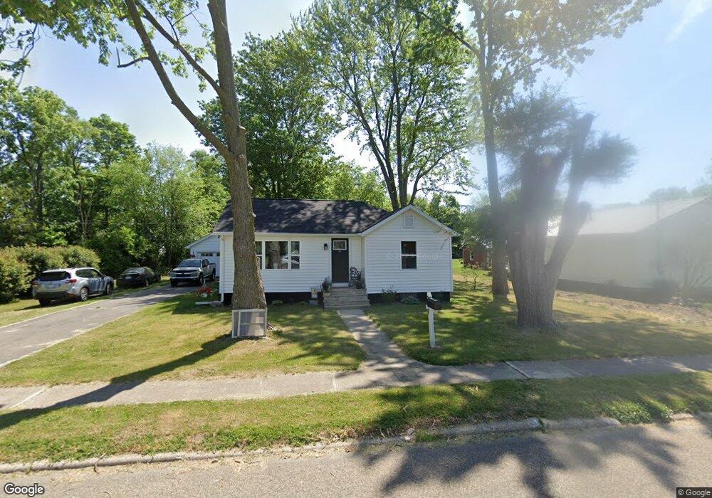
217 Mowry Ave Bronson, MI 49028
Estimated Value: $105,524 - $139,000
Studio
--
Bath
--
Sq Ft
17,860
Sq Ft Lot
About This Home
This home is located at 217 Mowry Ave, Bronson, MI 49028 and is currently estimated at $129,631. 217 Mowry Ave is a home located in Branch County with nearby schools including Ryan Elementary School, Anderson Elementary School, and Bronson Junior/Senior High School.
Ownership History
Date
Name
Owned For
Owner Type
Purchase Details
Closed on
Dec 23, 2021
Sold by
Healy Donald Bruce
Bought by
Healy Donald B and Cary Kassandra M
Current Estimated Value
Home Financials for this Owner
Home Financials are based on the most recent Mortgage that was taken out on this home.
Original Mortgage
$85,000
Outstanding Balance
$72,807
Interest Rate
3.11%
Mortgage Type
New Conventional
Estimated Equity
$56,824
Purchase Details
Closed on
May 15, 2020
Sold by
Hoard Richard E
Bought by
Healy Donald Bruce
Home Financials for this Owner
Home Financials are based on the most recent Mortgage that was taken out on this home.
Original Mortgage
$65,000
Interest Rate
3.3%
Mortgage Type
Credit Line Revolving
Create a Home Valuation Report for This Property
The Home Valuation Report is an in-depth analysis detailing your home's value as well as a comparison with similar homes in the area
Purchase History
| Date | Buyer | Sale Price | Title Company |
|---|---|---|---|
| Healy Donald B | -- | Oak Title Services Llc | |
| Healy Donald Bruce | $28,000 | None Available |
Source: Public Records
Mortgage History
| Date | Status | Borrower | Loan Amount |
|---|---|---|---|
| Open | Healy Donald B | $85,000 | |
| Closed | Healy Donald Bruce | $65,000 |
Source: Public Records
Tax History
| Year | Tax Paid | Tax Assessment Tax Assessment Total Assessment is a certain percentage of the fair market value that is determined by local assessors to be the total taxable value of land and additions on the property. | Land | Improvement |
|---|---|---|---|---|
| 2025 | $1,326 | $41,400 | $0 | $0 |
| 2024 | $12 | $42,000 | $0 | $0 |
| 2023 | $775 | $38,400 | $0 | $0 |
| 2022 | $1,225 | $31,600 | $0 | $0 |
| 2020 | -- | $29,300 | $0 | $0 |
| 2019 | -- | $26,200 | $0 | $0 |
| 2018 | -- | $23,400 | $0 | $0 |
| 2017 | -- | $22,900 | $0 | $0 |
| 2016 | -- | $22,900 | $0 | $0 |
| 2015 | -- | $21,200 | $0 | $0 |
| 2014 | -- | $20,100 | $0 | $0 |
| 2013 | -- | $23,100 | $0 | $0 |
Source: Public Records
Map
Nearby Homes
- 220 N Douglas St
- 410 Franklin St
- 644 S Matteson St
- 214 E Chicago St
- 509 N Walker St
- 150 Washington St
- 234 N Lincoln St
- 351 Roosevelt St
- 325 N Lincoln St
- 609 E Railroad St
- 0 Bawden Rd
- 130 Osborn Rd
- 1015 Brink Rd
- 1051 Brink Rd
- 368 Cranson Rd
- 141 S Snow Prairie Rd
- 828 N Werners Landing Dr
- 0 N Werners Landing Dr
- 786 W Colon Rd
- 0 Rierson Rd
- 229 Mowry Ave
- 437 Compton St
- 427 Compton St
- 230 Mowry Ave
- 230 S Ruggles St
- 411 Compton St
- 218 S Ruggles St
- 234 S Ruggles St
- 424 Compton St
- 123 Mowry Ave
- 306 S Ruggles St
- 138 S Ruggles St
- 132 S Ruggles St
- 325 Compton St
- 137 S Ruggles St
- 419 W Chicago St
- 305 S Ruggles St
- 435 W Chicago St
- 427 W Chicago St
- 124 S Ruggles St Unit Bldg-Unit
Your Personal Tour Guide
Ask me questions while you tour the home.