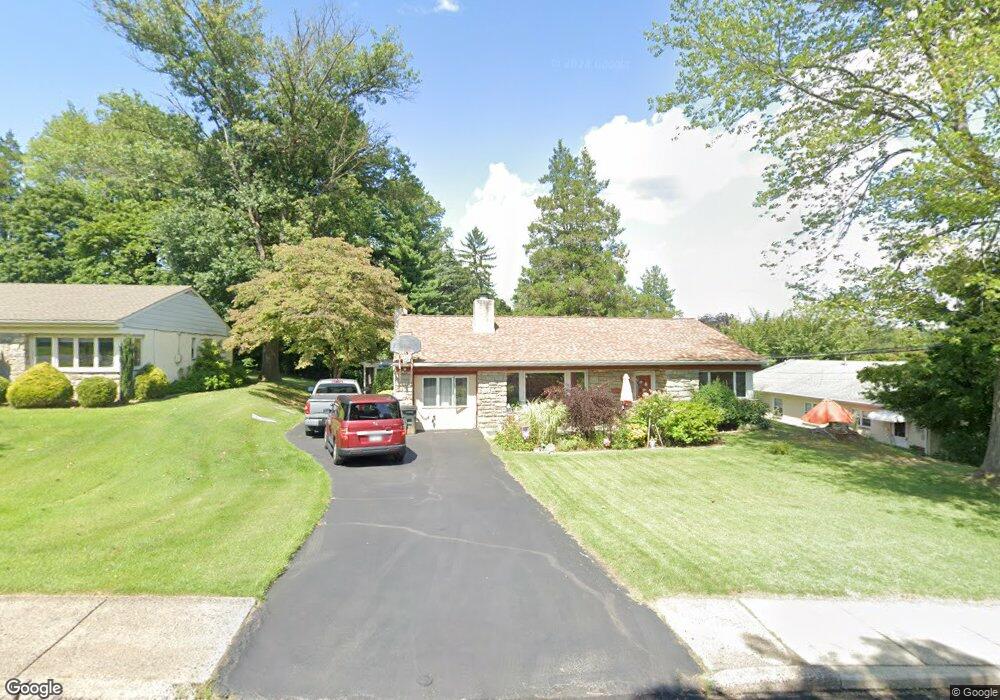
2181 Anthony Ave Broomall, PA 19008
Marple NeighborhoodEstimated Value: $488,000 - $647,000
4
Beds
3
Baths
2,344
Sq Ft
$248/Sq Ft
Est. Value
About This Home
This home is located at 2181 Anthony Ave, Broomall, PA 19008 and is currently estimated at $580,912, approximately $247 per square foot. 2181 Anthony Ave is a home located in Delaware County with nearby schools including Loomis Elementary School, Paxon Hollow Middle School, and Marple Newtown Senior High School.
Ownership History
Date
Name
Owned For
Owner Type
Purchase Details
Closed on
Apr 17, 2000
Sold by
Roder Heinrich and Roder Fereshteh
Bought by
Mcmanus Stephen A and Mcmanus Janice M
Current Estimated Value
Home Financials for this Owner
Home Financials are based on the most recent Mortgage that was taken out on this home.
Original Mortgage
$189,000
Outstanding Balance
$57,797
Interest Rate
8.23%
Estimated Equity
$523,115
Create a Home Valuation Report for This Property
The Home Valuation Report is an in-depth analysis detailing your home's value as well as a comparison with similar homes in the area
Home Values in the Area
Average Home Value in this Area
Purchase History
| Date | Buyer | Sale Price | Title Company |
|---|---|---|---|
| Mcmanus Stephen A | $210,000 | Fidelity National Title Ins |
Source: Public Records
Mortgage History
| Date | Status | Borrower | Loan Amount |
|---|---|---|---|
| Open | Mcmanus Stephen A | $189,000 |
Source: Public Records
Tax History
| Year | Tax Paid | Tax Assessment Tax Assessment Total Assessment is a certain percentage of the fair market value that is determined by local assessors to be the total taxable value of land and additions on the property. | Land | Improvement |
|---|---|---|---|---|
| 2026 | $6,412 | $337,730 | $112,670 | $225,060 |
| 2025 | $5,836 | $337,730 | $112,670 | $225,060 |
| 2024 | $5,836 | $337,730 | $112,670 | $225,060 |
| 2023 | $5,651 | $337,730 | $112,670 | $225,060 |
| 2022 | $5,544 | $337,730 | $112,670 | $225,060 |
| 2021 | $8,367 | $337,730 | $112,670 | $225,060 |
| 2020 | $4,401 | $152,940 | $57,500 | $95,440 |
| 2019 | $4,348 | $152,940 | $57,500 | $95,440 |
| 2018 | $4,303 | $152,940 | $0 | $0 |
| 2017 | $4,305 | $152,940 | $0 | $0 |
| 2016 | $839 | $152,940 | $0 | $0 |
| 2015 | $839 | $152,940 | $0 | $0 |
| 2014 | $839 | $152,940 | $0 | $0 |
Source: Public Records
Map
Nearby Homes
- 63 Lindbergh Ave
- 106 Lindbergh Ave
- 2312 Patricia Dr
- 14 Vassar Rd
- 1 Lawrence Rd Unit G2B
- 333 Golf Hills Rd
- 2431 Gilbert St
- 508 Circle Dr
- 221 Foxcroft Rd
- 15 Oakland Rd
- 617 Paddock Rd
- 41 Dorset Dr
- 85 2nd Ave
- 349 Glen Gary Dr
- 1700 Melrose Ave
- 310 Stanton Rd
- Lot 1 Cynwyd
- Lot 2 Cynwyd
- 152 3rd Ave
- 2203 Clover Dr
- 100 Thomas Ave
- 102 Thomas Ave
- 2185 Anthony Ave
- 23 Mather Ave
- 104 Thomas Ave
- 2178 Anthony Ave
- 109 N New Ardmore Ave
- 101 Thomas Ave
- 107 N New Ardmore Ave
- 21 Mather Ave
- 111 N New Ardmore Ave
- 2173 Thomas Ave
- 24 Mather Ave
- 2187 Anthony Ave
- 103 Thomas Ave
- 106 Thomas Ave
- 113 N New Ardmore Ave
- 2175 Thomas Ave
- 2166 Thomas Ave
- 22 Mather Ave
Your Personal Tour Guide
Ask me questions while you tour the home.