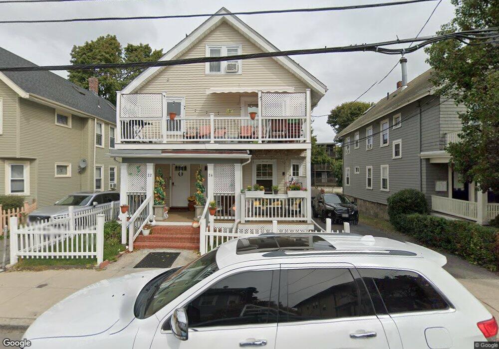
22 Archdale Rd Unit 24 Roslindale, MA 02131
Roslindale NeighborhoodEstimated Value: $963,000 - $1,111,718
5
Beds
4
Baths
3,135
Sq Ft
$332/Sq Ft
Est. Value
About This Home
This home is located at 22 Archdale Rd Unit 24, Roslindale, MA 02131 and is currently estimated at $1,039,430, approximately $331 per square foot. 22 Archdale Rd Unit 24 is a home located in Suffolk County with nearby schools including Brooke Charter School Roslindale, The Croft School - Jamaica Plain, and St. Clare High School.
Ownership History
Date
Name
Owned For
Owner Type
Purchase Details
Closed on
Aug 24, 2006
Sold by
Paulino Adolfo and Paulino Maria
Bought by
Paulino Maria
Current Estimated Value
Purchase Details
Closed on
Nov 1, 1994
Sold by
Kelly Kevin J
Bought by
Paulino Adolfo
Create a Home Valuation Report for This Property
The Home Valuation Report is an in-depth analysis detailing your home's value as well as a comparison with similar homes in the area
Home Values in the Area
Average Home Value in this Area
Purchase History
| Date | Buyer | Sale Price | Title Company |
|---|---|---|---|
| Paulino Maria | -- | -- | |
| Paulino Adolfo | $91,000 | -- |
Source: Public Records
Mortgage History
| Date | Status | Borrower | Loan Amount |
|---|---|---|---|
| Previous Owner | Paulino Adolfo | $50,000 | |
| Previous Owner | Paulino Adolfo | $262,000 |
Source: Public Records
Tax History
| Year | Tax Paid | Tax Assessment Tax Assessment Total Assessment is a certain percentage of the fair market value that is determined by local assessors to be the total taxable value of land and additions on the property. | Land | Improvement |
|---|---|---|---|---|
| 2025 | $11,682 | $1,008,800 | $254,000 | $754,800 |
| 2024 | $10,067 | $923,600 | $225,200 | $698,400 |
| 2023 | $9,447 | $879,600 | $214,400 | $665,200 |
| 2022 | $8,944 | $822,100 | $200,400 | $621,700 |
| 2021 | $8,517 | $798,200 | $194,600 | $603,600 |
| 2020 | $7,531 | $713,200 | $182,100 | $531,100 |
| 2019 | $7,027 | $666,700 | $146,700 | $520,000 |
| 2018 | $6,353 | $606,200 | $146,700 | $459,500 |
| 2017 | $6,353 | $599,900 | $146,700 | $453,200 |
| 2016 | $6,226 | $566,000 | $146,700 | $419,300 |
| 2015 | $6,754 | $557,700 | $146,200 | $411,500 |
| 2014 | $5,962 | $473,900 | $146,200 | $327,700 |
Source: Public Records
Map
Nearby Homes
- 3886-3888 Washington St
- 61 Fawndale Rd
- 6 Dellmore Rd Unit 3
- 6 Dellmore Rd Unit 2
- 167 Hyde Park Ave Unit 167A
- 52 Patten St Unit 3
- 348-350 Hyde Park Ave Unit 2
- 56 Patten St
- 52 Southbourne Rd
- 161 Florence St Unit 2
- 375 Hyde Park Ave Unit 3
- 2 Weld Hill St Unit PH2
- 40 Catherine St Unit B
- 40 Catherine St Unit 2
- 64 Hyde Park Ave Unit 3
- 71 Wyvern St
- 5 Martinwood Rd
- 134 Sycamore St
- 132 Sycamore St
- 5 St Unit 5
- 18 Archdale Rd Unit 20
- 26 Archdale Rd Unit 28
- 28 Archdale Rd Unit 2
- 14 Archdale Rd Unit 16
- 30 Archdale Rd Unit 32
- 14 Colgate Rd Unit 16
- 14 Colgate Rd Unit 16
- 14 Colgate Rd Unit 16
- 14 Colgate Rd Unit 2
- 10 Colgate Rd Unit 2
- 10 Colgate Rd Unit 1
- 10-12 Colgate Rd Unit 3
- 10-12 Colgate Rd Unit 1
- 14-16 Colgate Rd Unit 3
- 14-16 Colgate Rd
- 12 Colgate Rd Unit 2
- 10 Archdale Rd Unit 12
- 24 Colgate Rd Unit 1
- 24 Colgate Rd Unit 13
- 24 Colgate Rd Unit 9
Your Personal Tour Guide
Ask me questions while you tour the home.