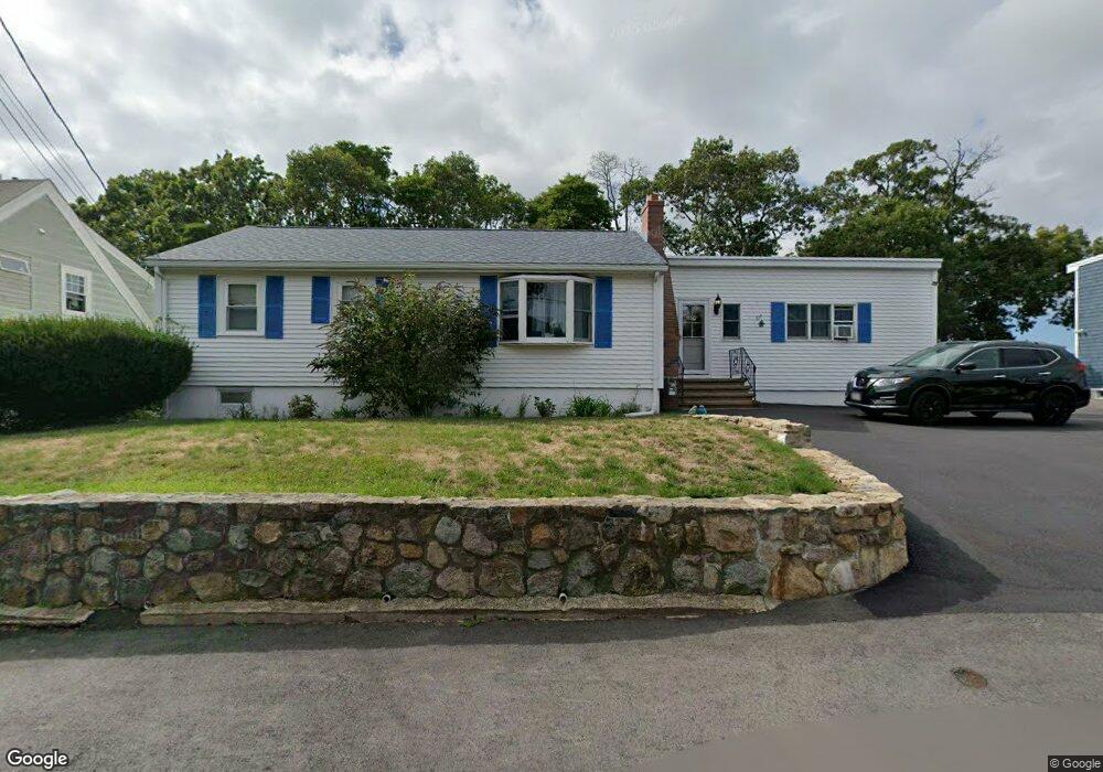
22 Green St Gloucester, MA 01930
Central Gloucester NeighborhoodEstimated Value: $492,000 - $609,000
3
Beds
1
Bath
1,317
Sq Ft
$427/Sq Ft
Est. Value
About This Home
This home is located at 22 Green St, Gloucester, MA 01930 and is currently estimated at $562,056, approximately $426 per square foot. 22 Green St is a home located in Essex County with nearby schools including East Veterans Memorial Elementary, Ralph B O'maley Middle School, and Gloucester High School.
Ownership History
Date
Name
Owned For
Owner Type
Purchase Details
Closed on
Jul 15, 2020
Sold by
Consiglio Philip
Bought by
Townsend Charles H and Townsend Deborah
Current Estimated Value
Home Financials for this Owner
Home Financials are based on the most recent Mortgage that was taken out on this home.
Original Mortgage
$150,500
Outstanding Balance
$132,257
Interest Rate
3.1%
Mortgage Type
New Conventional
Estimated Equity
$429,799
Purchase Details
Closed on
Nov 1, 1965
Bought by
Consiglio Philip and Consiglio Gail P
Create a Home Valuation Report for This Property
The Home Valuation Report is an in-depth analysis detailing your home's value as well as a comparison with similar homes in the area
Home Values in the Area
Average Home Value in this Area
Purchase History
| Date | Buyer | Sale Price | Title Company |
|---|---|---|---|
| Townsend Charles H | $315,000 | None Available | |
| Townsend Charles H | $315,000 | None Available | |
| Consiglio Philip | -- | -- |
Source: Public Records
Mortgage History
| Date | Status | Borrower | Loan Amount |
|---|---|---|---|
| Open | Townsend Charles H | $150,500 | |
| Closed | Townsend Charles H | $150,500 | |
| Previous Owner | Consiglio Philip | $528,000 | |
| Previous Owner | Consiglio Philip | $59,000 | |
| Previous Owner | Consiglio Philip | $45,000 |
Source: Public Records
Tax History
| Year | Tax Paid | Tax Assessment Tax Assessment Total Assessment is a certain percentage of the fair market value that is determined by local assessors to be the total taxable value of land and additions on the property. | Land | Improvement |
|---|---|---|---|---|
| 2025 | $4,528 | $465,800 | $163,300 | $302,500 |
| 2024 | $4,533 | $465,900 | $155,500 | $310,400 |
| 2023 | $4,562 | $430,800 | $138,900 | $291,900 |
| 2022 | $4,306 | $367,100 | $120,800 | $246,300 |
| 2021 | $4,338 | $348,700 | $109,800 | $238,900 |
| 2020 | $4,041 | $327,700 | $109,800 | $217,900 |
| 2019 | $4,000 | $315,200 | $109,800 | $205,400 |
| 2018 | $3,946 | $305,200 | $109,800 | $195,400 |
| 2017 | $3,768 | $285,700 | $98,900 | $186,800 |
| 2016 | $3,536 | $259,800 | $98,900 | $160,900 |
| 2015 | $3,625 | $265,600 | $98,900 | $166,700 |
Source: Public Records
Map
Nearby Homes
- 36 Eastern Ave
- 14R Spring St Unit 3
- 50 Warner St
- 40 Sargent St
- 113 Pleasant St
- 12 Arthur St
- 11 Wall St Unit R
- 9 Cleveland Place
- 3 Mondello Square
- 33 Maplewood Ave Unit 310
- 191 Main St Unit 3
- 191 Main St Unit 2A
- 8 Mystic Ave
- 98 Maplewood Ave
- 70 Bass Ave
- 26 Marina Dr
- 120 Washington St
- 35 Middle St Unit 4
- 33 Middle St
- 6 Monroe Ct
Your Personal Tour Guide
Ask me questions while you tour the home.