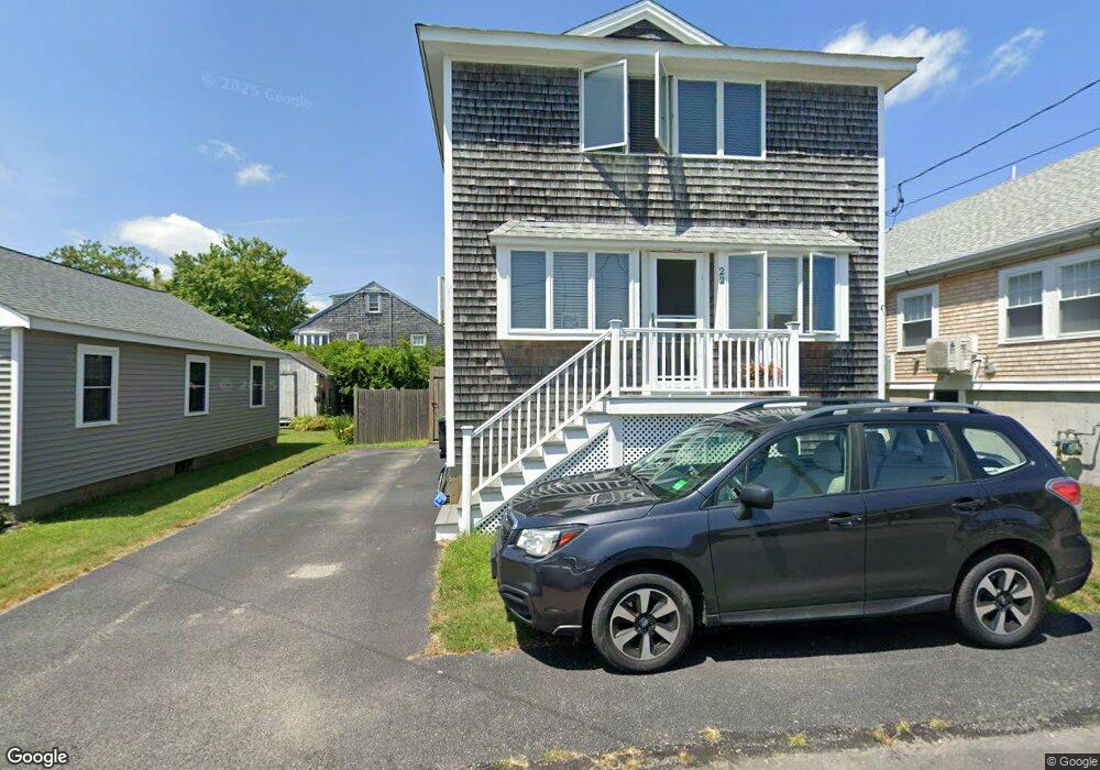
22 Roosevelt Rd Unit 1 Marshfield, MA 02050
Ocean Bluff-Brant Rock NeighborhoodEstimated Value: $696,000 - $781,000
3
Beds
2
Baths
1,650
Sq Ft
$454/Sq Ft
Est. Value
About This Home
This home is located at 22 Roosevelt Rd Unit 1, Marshfield, MA 02050 and is currently estimated at $749,407, approximately $454 per square foot. 22 Roosevelt Rd Unit 1 is a home located in Plymouth County with nearby schools including Daniel Webster, Furnace Brook Middle School, and Marshfield High School.
Ownership History
Date
Name
Owned For
Owner Type
Purchase Details
Closed on
Sep 29, 2020
Sold by
Doucette Marc S and Doucette Laurie B
Bought by
Marc S Doucette Ret and Doucette
Current Estimated Value
Purchase Details
Closed on
Oct 30, 2002
Sold by
Munroe David and Munroe Maxine
Bought by
Doucette Marc S and Doucette Laurie B
Home Financials for this Owner
Home Financials are based on the most recent Mortgage that was taken out on this home.
Original Mortgage
$240,000
Interest Rate
6.09%
Mortgage Type
Purchase Money Mortgage
Create a Home Valuation Report for This Property
The Home Valuation Report is an in-depth analysis detailing your home's value as well as a comparison with similar homes in the area
Home Values in the Area
Average Home Value in this Area
Purchase History
We collect this data history from publicly available records. To have your information removed, we recommend requesting removal directly through your county’s website.
| Date | Buyer | Sale Price | Title Company |
|---|---|---|---|
| Marc S Doucette Ret | -- | None Available | |
| Marc S Doucette Ret | -- | None Available | |
| Doucette Marc S | $300,000 | -- | |
| Doucette Marc S | $300,000 | -- |
Source: Public Records
Mortgage History
We collect this data history from publicly available records. To have your information removed, we recommend requesting removal directly through your county’s website.
| Date | Status | Borrower | Loan Amount |
|---|---|---|---|
| Previous Owner | Doucette Marc S | $240,000 | |
| Previous Owner | Doucette Marc S | $240,000 |
Source: Public Records
Tax History
| Year | Tax Paid | Tax Assessment Tax Assessment Total Assessment is a certain percentage of the fair market value that is determined by local assessors to be the total taxable value of land and additions on the property. | Land | Improvement |
|---|---|---|---|---|
| 2025 | $6,157 | $621,900 | $262,100 | $359,800 |
| 2024 | $5,739 | $552,400 | $245,700 | $306,700 |
| 2023 | $5,401 | $477,100 | $221,100 | $256,000 |
| 2022 | $5,092 | $393,200 | $188,400 | $204,800 |
| 2021 | $4,950 | $375,300 | $180,200 | $195,100 |
| 2020 | $4,546 | $341,000 | $155,600 | $185,400 |
| 2019 | $4,433 | $331,300 | $155,600 | $175,700 |
| 2018 | $4,429 | $331,300 | $155,600 | $175,700 |
| 2017 | $4,226 | $308,000 | $147,400 | $160,600 |
| 2016 | $4,054 | $292,100 | $139,200 | $152,900 |
| 2015 | $3,882 | $292,100 | $139,200 | $152,900 |
| 2014 | $3,715 | $279,500 | $139,200 | $140,300 |
Source: Public Records
Map
Nearby Homes
- 22 Roosevelt Rd
- 24 Roosevelt Rd
- 18 Roosevelt Rd
- 10 Dinitto Dr
- 9 Harding Rd
- 14 Roosevelt Rd
- 30 Roosevelt Rd
- 30 Roosevelt Rd Unit 1
- 15 Roosevelt Rd
- 25 Roosevelt Rd
- 27 Roosevelt Rd
- 11 Harding Rd
- 34 Roosevelt Rd
- 29 Roosevelt Rd
- 10 Harding Rd
- 723 Ocean St
- 11 Pershing Rd
- 35 Roosevelt Rd
- 729 Ocean St
- 737 Ocean St
Your Personal Tour Guide
Ask me questions while you tour the home.