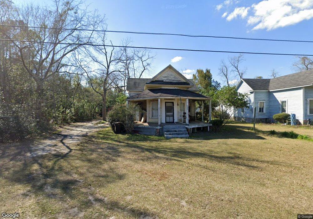
220 1st Ave Barney, GA 31625
Estimated Value: $81,000
Studio
2
Baths
1,300
Sq Ft
$62/Sq Ft
Est. Value
About This Home
This home is located at 220 1st Ave, Barney, GA 31625 and is currently estimated at $81,000, approximately $62 per square foot. 220 1st Ave is a home located in Brooks County with nearby schools including North Brooks Elementary School.
Ownership History
Date
Name
Owned For
Owner Type
Purchase Details
Closed on
Oct 25, 2021
Sold by
Martin Barbara
Bought by
Martin Thomas V
Current Estimated Value
Purchase Details
Closed on
Oct 14, 2003
Sold by
Nichols Pauline T
Bought by
Martin Barbara
Purchase Details
Closed on
Oct 18, 1994
Sold by
Taylor Warren E
Bought by
Nichols Pauline T
Purchase Details
Closed on
Aug 4, 1994
Sold by
Nichols Pauline T
Bought by
Taylor Warren E
Purchase Details
Closed on
Feb 22, 1991
Sold by
Nichols Mrs Pauline
Bought by
Nichols Pauline T
Purchase Details
Closed on
Dec 30, 1984
Sold by
Taylor Mrs John
Bought by
Nichols Mrs Pauline
Purchase Details
Closed on
Jun 9, 1983
Sold by
Taylor John G
Bought by
Taylor Mrs John
Create a Home Valuation Report for This Property
The Home Valuation Report is an in-depth analysis detailing your home's value as well as a comparison with similar homes in the area
Purchase History
| Date | Buyer | Sale Price | Title Company |
|---|---|---|---|
| Martin Thomas V | -- | -- | |
| Martin Barbara | $2,000 | -- | |
| Nichols Pauline T | -- | -- | |
| Taylor Warren E | $3,800 | -- | |
| Nichols Pauline T | -- | -- | |
| Nichols Mrs Pauline | -- | -- | |
| Taylor Mrs John | -- | -- |
Source: Public Records
Tax History
| Year | Tax Paid | Tax Assessment Tax Assessment Total Assessment is a certain percentage of the fair market value that is determined by local assessors to be the total taxable value of land and additions on the property. | Land | Improvement |
|---|---|---|---|---|
| 2025 | $79 | $1,520 | $1,520 | $0 |
| 2024 | $79 | $1,520 | $1,520 | $0 |
| 2023 | $73 | $1,280 | $1,280 | $0 |
| 2022 | $93 | $1,880 | $1,880 | $0 |
| 2021 | $620 | $10,560 | $440 | $10,120 |
| 2020 | $305 | $11,000 | $440 | $10,560 |
| 2019 | $536 | $9,120 | $440 | $8,680 |
| 2018 | $266 | $9,120 | $440 | $8,680 |
| 2017 | $491 | $8,920 | $440 | $8,480 |
| 2016 | $528 | $8,920 | $440 | $8,480 |
| 2015 | -- | $8,840 | $440 | $8,400 |
| 2014 | -- | $9,160 | $440 | $8,720 |
| 2013 | -- | $9,160 | $440 | $8,720 |
Source: Public Records
Map
Nearby Homes
- 1829 Blease Rd
- 0 Burton Rd Unit 23760976
- 0 Burton Rd Unit 23669194
- 693 Old Quitman Annex Rd
- 95 Azalea St
- 91 Azalea St
- 165 Fletcher St
- 11432 Adel Hwy
- 8200 Georgia 122
- 8170 Ga Highway 122 W
- 2476 Georgia 76
- Tract 3 Salem Church Rd
- Tract 5 Salem Church Rd
- 7959 Old Valdosta Rd N
- 8774 Antioch Rd
- 421 Best Cir
- 8009 Webb Rd N
- 787 Old Coffee Rd
- 7301 Shadow Creek Dr
- 7280 Mill Ridge Dr
- 208 1st Ave
- 194 1st Ave
- 241 1st Ave
- 168 1st Ave
- 177 1st Ave
- 241 Shantz Way (Lot D1)
- 148 1st Ave
- 141 1st Ave
- 13736 Ga Highway 122
- 214 Church St
- 127 2nd Ave
- 178 Church St
- 13774 Ga Highway 122
- 13773 Ga Highway 122
- 106 Brooks St
- 350 1st Ave
- 126 Church St
- 81 1st Ave
- 13727 Ga Highway 122
- 13660 Ga Highway 122
Your Personal Tour Guide
Ask me questions while you tour the home.