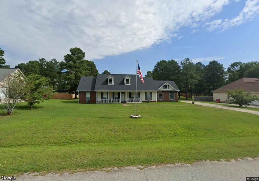
220 Natchez Trace Macon, GA 31216
Estimated Value: $218,000 - $272,000
3
Beds
2
Baths
1,456
Sq Ft
$165/Sq Ft
Est. Value
About This Home
This home is located at 220 Natchez Trace, Macon, GA 31216 and is currently estimated at $240,602, approximately $165 per square foot. 220 Natchez Trace is a home located in Bibb County with nearby schools including Heard Elementary School, Rutland Middle School, and Rutland High School.
Ownership History
Date
Name
Owned For
Owner Type
Purchase Details
Closed on
May 25, 2005
Sold by
Brilind Inc
Bought by
Spanberger Donald W
Current Estimated Value
Home Financials for this Owner
Home Financials are based on the most recent Mortgage that was taken out on this home.
Original Mortgage
$132,692
Interest Rate
5.69%
Mortgage Type
VA
Purchase Details
Closed on
Dec 20, 2004
Create a Home Valuation Report for This Property
The Home Valuation Report is an in-depth analysis detailing your home's value as well as a comparison with similar homes in the area
Purchase History
We collect this data history from publicly available records. To have your information removed, we recommend requesting removal directly through your county’s website.
| Date | Buyer | Sale Price | Title Company |
|---|---|---|---|
| Spanberger Donald W | $129,900 | None Avilebel | |
| -- | $27,900 | -- |
Source: Public Records
Mortgage History
We collect this data history from publicly available records. To have your information removed, we recommend requesting removal directly through your county’s website.
| Date | Status | Borrower | Loan Amount |
|---|---|---|---|
| Closed | Spanberger Donald W | $132,692 |
Source: Public Records
Tax History
| Year | Tax Paid | Tax Assessment Tax Assessment Total Assessment is a certain percentage of the fair market value that is determined by local assessors to be the total taxable value of land and additions on the property. | Land | Improvement |
|---|---|---|---|---|
| 2025 | -- | $87,066 | $8,000 | $79,066 |
| 2024 | $2,031 | $86,980 | $8,000 | $78,980 |
| 2023 | $1,478 | $83,204 | $6,000 | $77,204 |
| 2022 | $2,300 | $73,437 | $8,000 | $65,437 |
| 2021 | $2,059 | $61,173 | $8,000 | $53,173 |
| 2020 | $2,103 | $61,173 | $8,000 | $53,173 |
| 2019 | $1,612 | $48,184 | $8,000 | $40,184 |
| 2018 | $2,498 | $45,672 | $8,000 | $37,672 |
| 2017 | $1,449 | $45,672 | $8,000 | $37,672 |
| 2016 | $1,338 | $45,672 | $8,000 | $37,672 |
| 2015 | $1,894 | $45,672 | $8,000 | $37,672 |
| 2014 | $2,624 | $60,487 | $15,280 | $45,207 |
Source: Public Records
Map
Nearby Homes
- 319 Hawk Ct
- 317 Hawk Ct
- 312 Hawk Ct
- 412 Gray Wolf Dr
- 1419 Griffin Rd
- 1568 Griffin Rd
- 2011 Griffin Rd
- 1850 Barnes Ferry Rd
- 137 Abberley Ln Unit LOT 24
- 341 Stockton Cir Unit LOT 23
- 337 Stockton Cir Unit LOT 22
- 7070 Sofkee Place
- 101 Abberley Ln Unit LOT 12
- 2165 Griffin Rd
- 6629 Hawkinsville Rd
- 2154 Allen Rd
- 4068 Liberty Estates Dr
- 8410 Hawkinsville Rd Unit LOT 42
- 297 Amanda Dr
- 515 Amanda Way
- 218 Natchez Trace
- 222 Natchez Trace
- 221 Natchez Trace
- 219 Natchez Trace
- 224 Natchez Trace
- 301 Osage Ct
- 304 Buckskin Dr
- 217 Natchez Trace
- 305 Hawk Ct
- 306 Buckskin Dr
- 0 Gray Wolf Dr Unit 147157
- 0 Gray Wolf Dr Unit 147156
- 215 Natchez Trace
- 212 Natchez Trace Unit 58
- 212 Natchez Trace
- 0 Buckskin Dr Unit 7460806
- 310 Buckskin Dr
- 311 Hawk Ct
- 403 Gray Wolf Dr
- 211 Natchez Trace
Your Personal Tour Guide
Ask me questions while you tour the home.