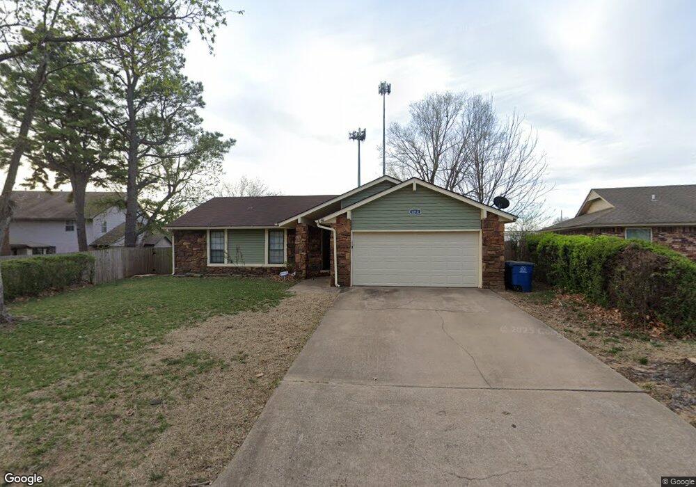
2210 W Haskell St Tulsa, OK 74127
Gilcrease Hills NeighborhoodEstimated Value: $203,000 - $262,000
3
Beds
2
Baths
1,910
Sq Ft
$122/Sq Ft
Est. Value
About This Home
This home is located at 2210 W Haskell St, Tulsa, OK 74127 and is currently estimated at $232,112, approximately $121 per square foot. 2210 W Haskell St is a home located in Osage County with nearby schools including Greenwood Leadership Academy, Central Middle School, and Central High School.
Ownership History
Date
Name
Owned For
Owner Type
Purchase Details
Closed on
Apr 8, 2024
Sold by
Bads Llc
Bought by
Horizon Rock Llc
Current Estimated Value
Purchase Details
Closed on
Jan 9, 2017
Bought by
Jeffers Julius J
Home Financials for this Owner
Home Financials are based on the most recent Mortgage that was taken out on this home.
Original Mortgage
$88,369
Interest Rate
4.2%
Purchase Details
Closed on
Oct 28, 1998
Sold by
Hering Maxeen Living Trust
Bought by
Sells Shunda
Purchase Details
Closed on
May 6, 1998
Sold by
Hering Maxeen
Bought by
Hering Maxeen Living Trust
Create a Home Valuation Report for This Property
The Home Valuation Report is an in-depth analysis detailing your home's value as well as a comparison with similar homes in the area
Home Values in the Area
Average Home Value in this Area
Purchase History
| Date | Buyer | Sale Price | Title Company |
|---|---|---|---|
| Horizon Rock Llc | $130,000 | Old Republic Title | |
| Jeffers Julius J | -- | -- | |
| Sells Shunda | $75,000 | -- | |
| Hering Maxeen Living Trust | -- | -- |
Source: Public Records
Mortgage History
| Date | Status | Borrower | Loan Amount |
|---|---|---|---|
| Previous Owner | Jeffers Julius J | $88,369 | |
| Previous Owner | Jeffers Julius J | -- |
Source: Public Records
Tax History
| Year | Tax Paid | Tax Assessment Tax Assessment Total Assessment is a certain percentage of the fair market value that is determined by local assessors to be the total taxable value of land and additions on the property. | Land | Improvement |
|---|---|---|---|---|
| 2025 | $1,639 | $14,168 | $1,315 | $12,853 |
| 2024 | $1,519 | $13,133 | $1,253 | $11,880 |
| 2023 | $1,519 | $12,507 | $1,253 | $11,254 |
| 2022 | $1,412 | $11,345 | $1,253 | $10,092 |
| 2021 | $1,329 | $11,345 | $1,253 | $10,092 |
| 2020 | $1,246 | $10,805 | $1,253 | $9,552 |
| 2019 | $1,326 | $10,805 | $1,253 | $9,552 |
| 2018 | $1,328 | $10,805 | $1,253 | $9,552 |
| 2017 | $1,330 | $10,801 | $1,253 | $9,548 |
| 2016 | $1,337 | $11,110 | $1,253 | $9,857 |
| 2015 | $1,263 | $10,581 | $1,253 | $9,328 |
| 2014 | $1,149 | $10,077 | $1,253 | $8,824 |
| 2013 | $1,094 | $9,598 | $1,253 | $8,345 |
Source: Public Records
Map
Nearby Homes
- 549 N 23rd West Ave
- 782 N Zenith Ave
- 2015 W Easton St
- 2701 W Haskell Place
- 254 N Yukon Ave
- 1810 W Independence St
- 1805 W Easton St
- 1907 W Cameron St
- 550 N Tacoma Ave
- 857 N Vancouver Ave
- 1812 W Reconciliation Way
- 314 N Tacoma Ave
- 2739 W Cameron St
- 1322 W Easton Place
- 1315 W Easton St
- 3027 W Cameron St
- 1821 W Archer St
- 4919 W Reconciliation Way
- 1717 W Newton St
- 1406 W Admiral Blvd
- 2214 W Haskell St
- 642 N Zenith Ave
- 636 N Zenith Ave
- 2220 W Haskell St
- 703 N Zenith Ave
- 2203 W Haskell St
- 2224 W Haskell St
- 709 N Zenith Ave
- 2120 W Haskell St
- 637 N Zenith Ave
- 2121 W Haskell St
- 2230 W Haskell St
- 717 N Zenith Ave
- 2116 W Haskell St
- 2111 W Golden St
- 2229 W Haskell St
- 2117 W Haskell St
- 712 N Zenith Ave
- 2236 W Haskell St
- 723 N Zenith Ave
Your Personal Tour Guide
Ask me questions while you tour the home.