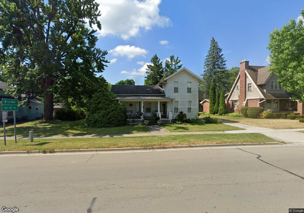
222 E Main St Morenci, MI 49256
Estimated Value: $132,000 - $171,000
3
Beds
1
Bath
1,856
Sq Ft
$80/Sq Ft
Est. Value
About This Home
This home is located at 222 E Main St, Morenci, MI 49256 and is currently estimated at $148,668, approximately $80 per square foot. 222 E Main St is a home located in Lenawee County with nearby schools including Morenci Elementary School and Morenci Middle/High School.
Ownership History
Date
Name
Owned For
Owner Type
Purchase Details
Closed on
Nov 1, 2018
Sold by
Wilsberg Carolyn and Wilsberg Paul A
Bought by
Bovee Traci
Current Estimated Value
Home Financials for this Owner
Home Financials are based on the most recent Mortgage that was taken out on this home.
Original Mortgage
$68,686
Outstanding Balance
$59,775
Interest Rate
4.7%
Mortgage Type
Purchase Money Mortgage
Estimated Equity
$88,893
Purchase Details
Closed on
Aug 19, 2008
Sold by
Wilsberg Carolyn
Bought by
Wilsberg Carolyn
Create a Home Valuation Report for This Property
The Home Valuation Report is an in-depth analysis detailing your home's value as well as a comparison with similar homes in the area
Home Values in the Area
Average Home Value in this Area
Purchase History
We collect this data history from publicly available records. To have your information removed, we recommend requesting removal directly through your county’s website.
| Date | Buyer | Sale Price | Title Company |
|---|---|---|---|
| Bovee Traci | $80,000 | -- | |
| Wilsberg Carolyn | -- | American Title Company Of Le |
Source: Public Records
Mortgage History
We collect this data history from publicly available records. To have your information removed, we recommend requesting removal directly through your county’s website.
| Date | Status | Borrower | Loan Amount |
|---|---|---|---|
| Open | Bovee Traci | $68,686 |
Source: Public Records
Tax History
| Year | Tax Paid | Tax Assessment Tax Assessment Total Assessment is a certain percentage of the fair market value that is determined by local assessors to be the total taxable value of land and additions on the property. | Land | Improvement |
|---|---|---|---|---|
| 2025 | $2,860 | $67,800 | $0 | $0 |
| 2024 | $18 | $61,600 | $0 | $0 |
| 2022 | $3,841 | $50,500 | $0 | $0 |
| 2020 | $1,914 | $46,100 | $0 | $0 |
| 2019 | $109,746 | $44,700 | $0 | $0 |
| 2018 | $109,746 | $41,286 | $0 | $0 |
| 2017 | $1,088 | $38,268 | $0 | $0 |
| 2016 | $0 | $37,411 | $0 | $0 |
| 2014 | -- | $35,854 | $0 | $0 |
Source: Public Records
Map
Nearby Homes
- 128 E Main St
- 309 E Locust St
- 215 S Summit St
- 403 E Main St
- 304 S East St
- 426 S East St
- 210 W Locust St
- 118 E Chestnut St
- 507 Page St
- 504 North St
- 236 W Congress St
- Block Skyline Dr
- 00 Coomer St Unit 9728 Coomer St
- 945 N Summit St
- 9581 Central Ave
- 515 Hammontree Dr
- 10454 M 156
- 16099 Us Highway 20
- 14640 County Road K
- 8058 Packard Rd
- 228 E Main St Unit 230
- 214 E Main St
- 204 E Main St
- 223 E Main St
- 229 E Main St
- 229 E Main St Unit MAIN
- 219 E Main St
- 219 E Main St Unit MAIN
- 235 E Main St
- 201 E Main St
- 207 E Main St
- 112 S East St
- 112 S East St Unit 112 East St South
- 112 S East St Unit EAST
- 119 N East St
- 127 N East St
- 144 E Main St
- 136 E Main St
- 304 E Main St
- 210 E Locust St
Your Personal Tour Guide
Ask me questions while you tour the home.