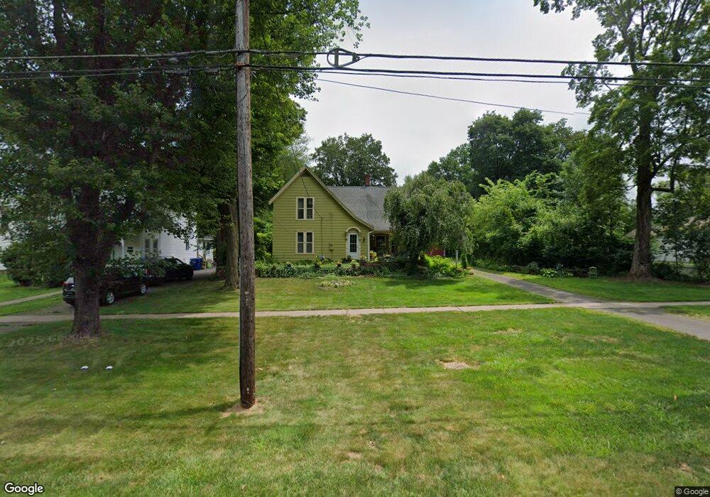
222 S Main St Suffield, CT 06078
Estimated Value: $389,000 - $436,000
3
Beds
2
Baths
1,967
Sq Ft
$210/Sq Ft
Est. Value
About This Home
This home is located at 222 S Main St, Suffield, CT 06078 and is currently estimated at $412,652, approximately $209 per square foot. 222 S Main St is a home located in Hartford County with nearby schools including A. Ward Spaulding School, Mcalister Intermediate School, and Suffield Middle School.
Ownership History
Date
Name
Owned For
Owner Type
Purchase Details
Closed on
Jun 17, 1997
Sold by
Mosimam Kristin and Obrien Sean
Bought by
Denno Brian and Denno Andrea
Current Estimated Value
Purchase Details
Closed on
Jul 19, 1993
Sold by
Campbell Caroline
Bought by
Obrien Sean and Mosimann Kristin
Create a Home Valuation Report for This Property
The Home Valuation Report is an in-depth analysis detailing your home's value as well as a comparison with similar homes in the area
Home Values in the Area
Average Home Value in this Area
Purchase History
| Date | Buyer | Sale Price | Title Company |
|---|---|---|---|
| Denno Brian | $148,200 | -- | |
| Obrien Sean | $142,000 | -- |
Source: Public Records
Mortgage History
| Date | Status | Borrower | Loan Amount |
|---|---|---|---|
| Open | Obrien Sean | $240,800 | |
| Closed | Obrien Sean | $30,100 | |
| Closed | Obrien Sean | $208,000 |
Source: Public Records
Tax History
| Year | Tax Paid | Tax Assessment Tax Assessment Total Assessment is a certain percentage of the fair market value that is determined by local assessors to be the total taxable value of land and additions on the property. | Land | Improvement |
|---|---|---|---|---|
| 2025 | $5,545 | $236,880 | $82,880 | $154,000 |
| 2024 | $5,361 | $236,880 | $82,880 | $154,000 |
| 2023 | $5,385 | $188,230 | $82,880 | $105,350 |
| 2022 | $5,385 | $188,230 | $82,880 | $105,350 |
| 2021 | $5,391 | $188,230 | $82,880 | $105,350 |
| 2020 | $5,391 | $188,230 | $82,880 | $105,350 |
| 2019 | $5,406 | $188,230 | $82,880 | $105,350 |
| 2018 | $5,720 | $195,090 | $76,370 | $118,720 |
| 2017 | $5,636 | $195,090 | $76,370 | $118,720 |
| 2016 | $5,502 | $195,090 | $76,370 | $118,720 |
| 2015 | $5,420 | $195,090 | $76,370 | $118,720 |
| 2014 | $5,291 | $195,090 | $76,370 | $118,720 |
Source: Public Records
Map
Nearby Homes
- 186 S Main St
- 0 Stone St S Unit 24039713
- 15 High St
- 18 Daniel Cir Unit 18
- 61 Brandywine Ln
- 392 Boston Neck Rd
- 39 Marbern Dr
- 0 Suffield St Unit 24093452
- 0 Suffield St Unit 24057050
- 1 E Elaine Dr
- 424 Bridge St
- 72 Spencer St
- 713 Thrall Ave
- 779 Bridge St
- 840 Branch Rd
- 0 Hale St Unit 96
- 977 Sheldon St
- 278 Thompsonville Rd
- 660 East St S
- 610 East St S
- 214 S Main St
- 208 S Main St
- 0 S Main St
- 202 S Main St
- 200 S Main St
- 225 S Main St
- 221 S Main St
- 186 S Main St Unit 196
- 264 S Main St
- 217 S Main St
- 198 S Main St
- 10 Willow Creek Ave
- 127 Ellison St
- 9 Willow Creek Ave
- 195 S Main St
- 62 Kent Ave
- 12 Willow Creek Ave
- 249 S Main St
- 189 S Main St Unit 189
- 41 Kent Ave
Your Personal Tour Guide
Ask me questions while you tour the home.