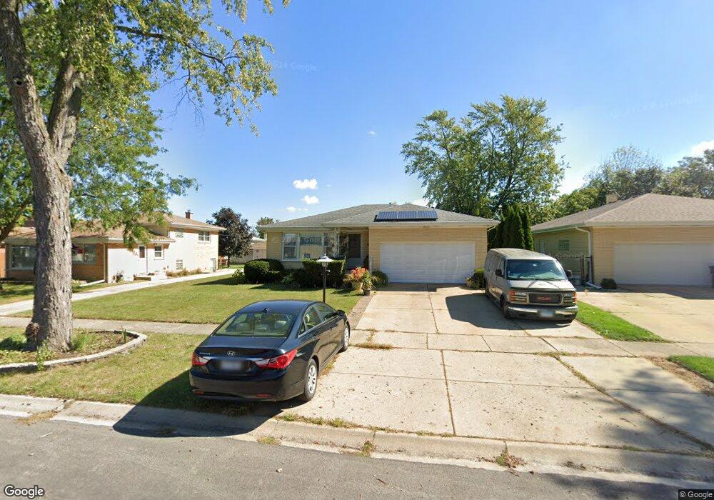
2221 Ash St Des Plaines, IL 60018
Estimated Value: $330,000 - $452,000
3
Beds
1
Bath
1,221
Sq Ft
$330/Sq Ft
Est. Value
About This Home
This home is located at 2221 Ash St, Des Plaines, IL 60018 and is currently estimated at $402,613, approximately $329 per square foot. 2221 Ash St is a home located in Cook County with nearby schools including Plainfield Elementary School, Algonquin Middle School, and Maine West High School.
Ownership History
Date
Name
Owned For
Owner Type
Purchase Details
Closed on
Jun 23, 2009
Sold by
Rutkowski Zbigniew
Bought by
Rutkowski Zbigniew and Rutkowski Kmitta Violet
Current Estimated Value
Purchase Details
Closed on
May 28, 2009
Sold by
Hrbacek Martha and Wurmbach Monica
Bought by
Rutkowski Zbigniew
Purchase Details
Closed on
Jul 27, 2004
Sold by
Mueller Katharina
Bought by
Mueller Katharina and The Alexander Mueller Family Trust
Purchase Details
Closed on
Apr 5, 2000
Sold by
Mueller Alexander and Mueller Katharina
Bought by
Mueller Alexander and Mueller Katharina
Create a Home Valuation Report for This Property
The Home Valuation Report is an in-depth analysis detailing your home's value as well as a comparison with similar homes in the area
Home Values in the Area
Average Home Value in this Area
Purchase History
| Date | Buyer | Sale Price | Title Company |
|---|---|---|---|
| Rutkowski Zbigniew | -- | Mid America Title Company | |
| Rutkowski Zbigniew | $250,000 | None Available | |
| Mueller Katharina | -- | -- | |
| Mueller Alexander | -- | -- |
Source: Public Records
Tax History
| Year | Tax Paid | Tax Assessment Tax Assessment Total Assessment is a certain percentage of the fair market value that is determined by local assessors to be the total taxable value of land and additions on the property. | Land | Improvement |
|---|---|---|---|---|
| 2025 | $6,864 | $36,000 | $8,778 | $27,222 |
| 2024 | $6,864 | $32,000 | $7,315 | $24,685 |
| 2023 | $6,650 | $32,000 | $7,315 | $24,685 |
| 2022 | $6,650 | $32,000 | $7,315 | $24,685 |
| 2021 | $5,623 | $24,286 | $4,754 | $19,532 |
| 2020 | $5,652 | $24,286 | $4,754 | $19,532 |
| 2019 | $5,682 | $27,288 | $4,754 | $22,534 |
| 2018 | $4,479 | $21,849 | $4,206 | $17,643 |
| 2017 | $4,634 | $21,849 | $4,206 | $17,643 |
| 2016 | $6,071 | $21,849 | $4,206 | $17,643 |
| 2015 | $5,021 | $21,105 | $3,657 | $17,448 |
| 2014 | $5,486 | $21,105 | $3,657 | $17,448 |
| 2013 | $5,332 | $21,105 | $3,657 | $17,448 |
Source: Public Records
Map
Nearby Homes
- 1370 Fargo Ave Unit E
- 2129 Ash St Unit G
- 1629 E Touhy Ave
- 1641 E Touhy Ave
- 1857 Pine St
- 1738 Lunt Ave
- 1830 Dexter Ln
- 2124 Westview Dr
- 805 S Tures Ln
- 1881 Orchard St
- 2323 Douglas Ave
- 1678 Ash St
- 2232 Sprucewood Ave
- 2646 Maple St
- 1693 Linden St
- 616 Birchwood Ave
- 614 Birchwood Ave
- 1757 Farwell Ave
- 1789 Farwell Ave
- 1541 Cooper St
Your Personal Tour Guide
Ask me questions while you tour the home.