Estimated Value: $530,000 - $640,000
3
Beds
3
Baths
1,298
Sq Ft
$443/Sq Ft
Est. Value
About This Home
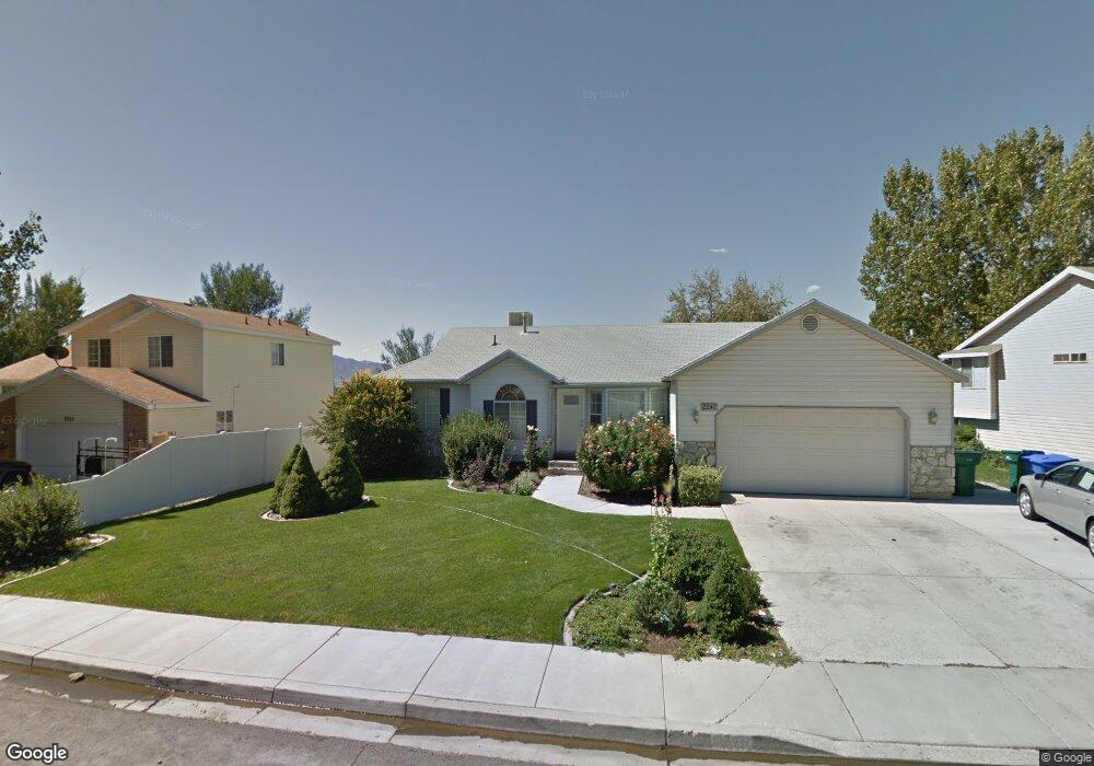
This home is located at 2247 Sunset Dr, Lehi, UT 84043 and is currently estimated at $575,570, approximately $443 per square foot. 2247 Sunset Dr is a home located in Utah County with nearby schools including Fox Hollow Elementary School, Skyridge High School, and Ignite Entrepreneurship Academy.
Ownership History
Date
Name
Owned For
Owner Type
Purchase Details
Closed on
Mar 13, 2023
Sold by
Anderton Aaron
Bought by
2247 Sunset Dr Llc
Current Estimated Value
Purchase Details
Closed on
May 18, 2020
Sold by
Orgill Frederick A and Orgill Christine P
Bought by
Anderton Aaron and Anderton Megan
Home Financials for this Owner
Home Financials are based on the most recent Mortgage that was taken out on this home.
Original Mortgage
$350,500
Interest Rate
3.3%
Mortgage Type
New Conventional
Create a Home Valuation Report for This Property
The Home Valuation Report is an in-depth analysis detailing your home's value as well as a comparison with similar homes in the area
Home Values in the Area
Average Home Value in this Area
Purchase History
| Date | Buyer | Sale Price | Title Company |
|---|---|---|---|
| 2247 Sunset Dr Llc | -- | Sutherland Title | |
| Anderton Aaron | -- | Gt Title Services |
Source: Public Records
Mortgage History
| Date | Status | Borrower | Loan Amount |
|---|---|---|---|
| Previous Owner | Anderton Aaron | $350,500 |
Source: Public Records
Tax History
| Year | Tax Paid | Tax Assessment Tax Assessment Total Assessment is a certain percentage of the fair market value that is determined by local assessors to be the total taxable value of land and additions on the property. | Land | Improvement |
|---|---|---|---|---|
| 2025 | $2,392 | $312,345 | -- | -- |
| 2024 | $2,223 | $279,950 | $0 | $0 |
| 2023 | $2,223 | $282,480 | $0 | $0 |
| 2022 | $2,466 | $303,765 | $0 | $0 |
| 2021 | $2,133 | $397,200 | $110,200 | $287,000 |
| 2020 | $1,799 | $331,200 | $102,000 | $229,200 |
| 2019 | $1,574 | $301,300 | $102,000 | $199,300 |
| 2018 | $1,616 | $292,300 | $93,000 | $199,300 |
| 2017 | $1,509 | $145,145 | $0 | $0 |
| 2016 | $1,397 | $124,630 | $0 | $0 |
| 2015 | $1,445 | $122,375 | $0 | $0 |
| 2014 | $1,330 | $112,035 | $0 | $0 |
Source: Public Records
Map
Nearby Homes
- 1940 N 900 W
- 1127 W State St
- 974 W State St
- 2600 N 1200 W Unit 6
- 416 W 2070 N
- 459 W 2600 N
- 2778 N 930 W
- 850 W State St
- 824 W 2800 N
- 495 W 1850 N
- 2712 N Park View Ct
- 398 W 2660 N
- 356 W 1850 N Unit 6
- 2908 N 1080 W
- 1194 W 2900 N
- 1155 W 2980 N
- 1195 W 2980 N
- 1760 N 340 W
- 2918 N 1310 W Unit D
- 1340 W 2910 N Unit EE3
- 2247 N Sunset Dr
- 2235 N Sunset Dr
- 2235 Sunset Dr
- 2261 N Sunset Dr
- 2225 N Sunset Dr
- 2225 Sunset Dr
- 797 W 2260 N
- 2261 Sunset Dr
- 2263 N 790 W
- 2264 Sunset Dr
- 2264 N Sunset Dr
- 2269 Sunset Dr
- 2221 N Sunset Dr
- 2224 Sunset Dr
- 789 W 2260 N
- 2221 Sunset Dr
- 2279 N 790 W
- 2199 N Sunset Dr
- 2199 N Sunset Dr
- 2199 N Sunset Dr
Your Personal Tour Guide
Ask me questions while you tour the home.