
C
Seller's Agent in 2026
Courtney Mullin
Meadow and Main Inc.
(319) 209-8089
9 Total Sales
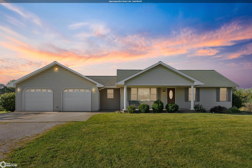
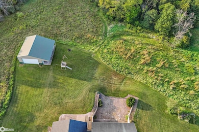
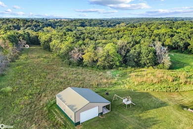
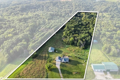

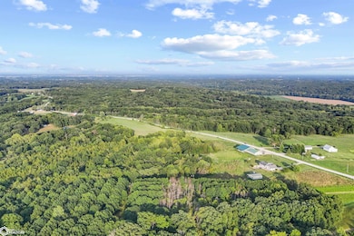

Welcome to your own private retreat in the countryside of West Point! This stunning property offers 11.19 acres of rolling land and a beautiful home with a walkout basement, creating the perfect blend of comfort and wide-open space. Inside, you'll love the open concept design that makes entertaining easy and everyday living feel bright and spacious. The updated kitchen is the heart of the home-offering modern style and function for everything from quick weeknight meals to big family gatherings. Wildlife enthusiasts will love the frequent deer traffic and natural setting that makes every morning and evening a scene from a postcard. The spacious acreage provides plenty of opportunities for recreation, gardening, or future outbuildings. The walkout basement extends your living space, invites natural light, and provides seamless access to the outdoors. Located just outside West Point, you'll enjoy the quiet privacy of country living while still being a short drive to town conveniences. Properties like this are a rare find=don't miss your change to make this one yours! *Listing agent has a familial relationship to the seller.
Last Agent to Sell the Property
Meadow and Main Inc. License #*** Listed on: 09/05/2025
| Date | Type | Sale Price | Title Company |
|---|---|---|---|
| Warranty Deed | $75,000 | None Available |
| Date | Status | Loan Amount | Loan Type |
|---|---|---|---|
| Closed | $33,000 | Unknown |
| Date | Event | Price | List to Sale | Price per Sq Ft |
|---|---|---|---|---|
| 01/16/2026 01/16/26 | Sold | $358,250 | -12.6% | $192 / Sq Ft |
| 10/21/2025 10/21/25 | Price Changed | $410,000 | -5.7% | $219 / Sq Ft |
| 10/07/2025 10/07/25 | Price Changed | $435,000 | -3.3% | $233 / Sq Ft |
| 09/22/2025 09/22/25 | Price Changed | $450,000 | -3.2% | $241 / Sq Ft |
| 09/05/2025 09/05/25 | For Sale | $465,000 | -- | $249 / Sq Ft |
| Year | Tax Paid | Tax Assessment Tax Assessment Total Assessment is a certain percentage of the fair market value that is determined by local assessors to be the total taxable value of land and additions on the property. | Land | Improvement |
|---|---|---|---|---|
| 2025 | $3,012 | $299,370 | $39,040 | $260,330 |
| 2024 | $3,012 | $246,210 | $21,720 | $224,490 |
| 2023 | $2,972 | $246,210 | $21,720 | $224,490 |
| 2022 | $2,328 | $186,110 | $18,800 | $167,310 |
| 2021 | $2,328 | $186,110 | $18,800 | $167,310 |
| 2020 | $2,320 | $173,240 | $19,930 | $153,310 |
| 2019 | $2,246 | $184,370 | $31,060 | $153,310 |
| 2018 | $2,330 | $163,430 | $0 | $0 |
| 2017 | $2,330 | $155,820 | $0 | $0 |
| 2016 | $2,120 | $155,820 | $0 | $0 |
| 2015 | $2,120 | $153,020 | $0 | $0 |
| 2014 | $2,026 | $153,020 | $0 | $0 |
C
Seller's Agent in 2026
Courtney Mullin
Meadow and Main Inc.
(319) 209-8089
9 Total Sales
S
Buyer's Agent in 2026
Steven Fey
Meadow and Main Inc.
(970) 674-1990
5 Total Sales
Source: NoCoast MLS
MLS Number: NOC6331555
APN: 02-31-08-18-400-0090
Disclaimer: Certain information contained herein is derived from information provided by parties other than Homes.com. All information provided is deemed reliable, but is not guaranteed to be accurate and should be independently verified.
![]() Based on information submitted to the MLS GRID. All data is obtained from various sources and may not have been verified by broker or MLS GRID. Supplied Open House Information is subject to change without notice. All information should be independently reviewed and verified for accuracy. Properties may or may not be listed by the office/agent presenting the information. Some IDX listings have been excluded from this website. IDX information is provided exclusively for personal, non-commercial use, and may not be used for any purpose other than to identify prospective properties consumers may be interested in purchasing.
Based on information submitted to the MLS GRID. All data is obtained from various sources and may not have been verified by broker or MLS GRID. Supplied Open House Information is subject to change without notice. All information should be independently reviewed and verified for accuracy. Properties may or may not be listed by the office/agent presenting the information. Some IDX listings have been excluded from this website. IDX information is provided exclusively for personal, non-commercial use, and may not be used for any purpose other than to identify prospective properties consumers may be interested in purchasing.
Information is deemed reliable but not guaranteed.
Based on information submitted to the MLS GRID
Listings courtesy of NoCoast MLS as distributed by MLS GRID
Ask me questions while you tour the home.