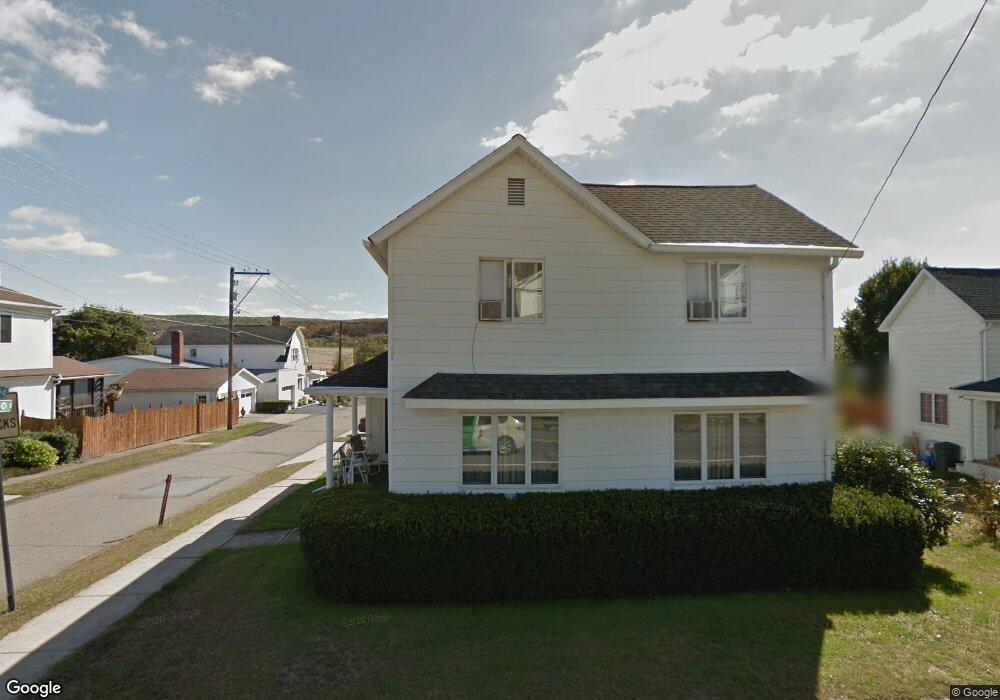
226 Depew Ave Mayfield, PA 18433
Estimated Value: $119,636 - $186,000
3
Beds
1
Bath
1,188
Sq Ft
$133/Sq Ft
Est. Value
About This Home
This home is located at 226 Depew Ave, Mayfield, PA 18433 and is currently estimated at $158,159, approximately $133 per square foot. 226 Depew Ave is a home located in Lackawanna County with nearby schools including Lakeland Junior/Senior High School and Edison Early Learning Center.
Ownership History
Date
Name
Owned For
Owner Type
Purchase Details
Closed on
Oct 13, 2009
Sold by
Chrusch Theodore and Chrusch Beth E
Bought by
Burns Nadine E
Current Estimated Value
Home Financials for this Owner
Home Financials are based on the most recent Mortgage that was taken out on this home.
Original Mortgage
$81,182
Outstanding Balance
$51,650
Interest Rate
5.06%
Mortgage Type
FHA
Estimated Equity
$106,509
Create a Home Valuation Report for This Property
The Home Valuation Report is an in-depth analysis detailing your home's value as well as a comparison with similar homes in the area
Home Values in the Area
Average Home Value in this Area
Purchase History
| Date | Buyer | Sale Price | Title Company |
|---|---|---|---|
| Burns Nadine E | $82,680 | None Available |
Source: Public Records
Mortgage History
| Date | Status | Borrower | Loan Amount |
|---|---|---|---|
| Open | Burns Nadine E | $81,182 |
Source: Public Records
Tax History
| Year | Tax Paid | Tax Assessment Tax Assessment Total Assessment is a certain percentage of the fair market value that is determined by local assessors to be the total taxable value of land and additions on the property. | Land | Improvement |
|---|---|---|---|---|
| 2025 | $1,603 | $6,000 | $0 | $6,000 |
| 2024 | $1,342 | $6,000 | $0 | $6,000 |
| 2023 | $1,342 | $6,000 | $0 | $6,000 |
| 2022 | $1,296 | $6,000 | $0 | $6,000 |
| 2021 | $1,296 | $6,000 | $0 | $6,000 |
| 2020 | $1,284 | $6,000 | $0 | $6,000 |
| 2019 | $1,212 | $6,000 | $0 | $6,000 |
| 2018 | $1,200 | $6,000 | $0 | $6,000 |
| 2017 | $1,188 | $6,000 | $0 | $6,000 |
| 2016 | $581 | $6,000 | $0 | $0 |
| 2015 | -- | $6,000 | $0 | $0 |
| 2014 | -- | $6,000 | $0 | $0 |
Source: Public Records
Map
Nearby Homes
- 302 Depew Ave
- 205 Depew Ave
- 210 Gorham Ave
- 705 Jefferson Ave
- 0 Pennsylvania 107
- 414 Rushbrook St
- 103 5th St
- 727 Lackawanna Ave
- 213 Raymond Dr
- 440 Washington Ave
- 432 Madison Ave
- 0 Chestnut St
- 925 Lackawanna Ave
- 21 Maple St
- 439 Hudson St
- 3 Old Mill Rd
- 717 N Main St
- 119 Osprey Ln
- 192 Shadow Wood Cir
- 133 Gordon Ave
- 222 Depew Ave
- 406 Glenwood St
- 300 Depew Ave
- 218 Depew Ave
- 225 Depew Ave
- 303 Depew Ave
- 200 Depew Ave
- 214 Depew Ave
- 216 Glenwood St
- 216 Depew Ave
- 308 Glenwood St
- 0 Glenwood Ave Unit GSB085817
- 0 Glenwood St Unit GSB064104
- 227 Depew Ave
- 212 Depew Ave
- 304 Depew Ave
- 216 Whitmore Ave
- 213 Depew Ave
- 300 Whitmore Ave
- 210 Depew Ave
Your Personal Tour Guide
Ask me questions while you tour the home.