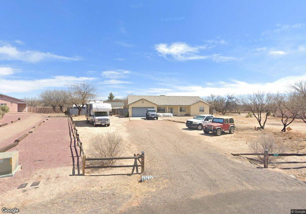
227 W Corral Dr Saint David, AZ 85630
Estimated Value: $303,822 - $390,000
About This Home
This home is located at 227 W Corral Dr, Saint David, AZ 85630 and is currently estimated at $361,956, approximately $196 per square foot. 227 W Corral Dr is a home located in Cochise County with nearby schools including St. David Elementary School and St. David High School.
Ownership History
We collect this data history from publicly available records. To have your information removed, we recommend requesting removal directly through your county’s website.
Purchase Details
Home Financials for this Owner
Home Financials are based on the most recent Mortgage that was taken out on this home.Purchase Details
Home Financials for this Owner
Home Financials are based on the most recent Mortgage that was taken out on this home.Purchase Details
Purchase History
We collect this data history from publicly available records. To have your information removed, we recommend requesting removal directly through your county’s website.
| Date | Buyer | Sale Price | Title Company |
|---|---|---|---|
| -- | Boston National Ttl Agcy Llc | ||
| -- | Boston National Title | ||
| -- | Pioneer Title Agency Inc | ||
| -- | Pioneer Title Agency Inc |
Mortgage History
We collect this data history from publicly available records. To have your information removed, we recommend requesting removal directly through your county’s website.
| Date | Status | Borrower | Loan Amount |
|---|---|---|---|
| Previous Owner | $112,000 | ||
| Previous Owner | $112,000 |
Tax History
We collect this data history from publicly available records. To have your information removed, we recommend requesting removal directly through your county’s website.
| Year | Tax Paid | Tax Assessment Tax Assessment Total Assessment is a certain percentage of the fair market value that is determined by local assessors to be the total taxable value of land and additions on the property. | Land | Improvement |
|---|---|---|---|---|
| 2025 | $2,135 | $23,952 | $3,200 | $20,752 |
| 2024 | $2,135 | $23,583 | $3,200 | $20,383 |
| 2023 | $2,153 | $20,353 | $3,200 | $17,153 |
| 2022 | $1,770 | $17,480 | $3,200 | $14,280 |
| 2021 | $1,784 | $16,274 | $3,200 | $13,074 |
| 2020 | $1,872 | $0 | $0 | $0 |
| 2019 | $1,804 | $0 | $0 | $0 |
| 2018 | $1,725 | $0 | $0 | $0 |
| 2017 | $1,685 | $0 | $0 | $0 |
| 2016 | $1,736 | $0 | $0 | $0 |
| 2015 | -- | $0 | $0 | $0 |
Map
- TBD N Country Way 6 88 Acres --
- TBD N
- 201 E Pederson Dr
- 0 N Jacobs Rd Unit 22602536
- 115 N Kempton Way
- 9.93 ac E Taylor Pass
- 0 E Taylor Pass Unit 22613665
- 9.93 ac S Lonesome Rd
- 39 W Patton St
- 439 W Patton St
- 000 S Ewing St
- 1577 S Flynn Rd
- 2948 Highway 80 Riverbend Unit 1
- 0 Tbd 130 Unit 130 22314630
- 1214 S Emu Ave
- TBD N Highway 80 Hwy
- TBD Crescent
- 587 N Arizona State Route Highway 80 Unit 7
- 1115 N Mill Iron Rd
- 801 S Lee St Unit 246
- 717 N Saddlehorn Dr
- 224 W Corral Dr
- 251 W Corral Dr
- 250 W Corral Ct
- 716 N Mesquite Dr
- 695 N Saddlehorn Dr
- 700 N Saddlehorn Dr
- 277 W Corral Ct
- 276 W Corral Dr
- 276 W Corral Ct
- 658 N Mesquite Dr
- 685 N Saddlehorn Dr
- 744 N Mesquite Dr
- 684 N Saddlehorn Dr
- 301 W Corral Dr
- 280 W Branding Iron Dr
- 301 W Corral Ct
- 300 W Corral Ct
- 641 N Saddlehorn Dr
- 638 N Saddlehorn Dr
Ask me questions while you tour the home.