Estimated Value: $179,000 - $199,000
3
Beds
2
Baths
864
Sq Ft
$221/Sq Ft
Est. Value
About This Home
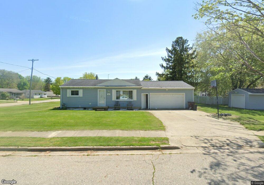
This home is located at 230 Devon Hill Dr, Mason, MI 48854 and is currently estimated at $190,553, approximately $220 per square foot. 230 Devon Hill Dr is a home located in Ingham County with nearby schools including Mason High School.
Ownership History
Date
Name
Owned For
Owner Type
Purchase Details
Closed on
Oct 25, 2002
Sold by
Slattery Timothy B and Slattery Michelle R
Bought by
Blik Michael J and Blik Amy
Current Estimated Value
Home Financials for this Owner
Home Financials are based on the most recent Mortgage that was taken out on this home.
Original Mortgage
$96,400
Outstanding Balance
$41,446
Interest Rate
6.38%
Mortgage Type
Purchase Money Mortgage
Estimated Equity
$149,107
Purchase Details
Closed on
May 19, 1987
Sold by
Slat Michelle
Create a Home Valuation Report for This Property
The Home Valuation Report is an in-depth analysis detailing your home's value as well as a comparison with similar homes in the area
Home Values in the Area
Average Home Value in this Area
Purchase History
We collect this data history from publicly available records. To have your information removed, we recommend requesting removal directly through your county’s website.
| Date | Buyer | Sale Price | Title Company |
|---|---|---|---|
| Blik Michael J | $120,500 | Bell Title Company | |
| -- | $47,800 | -- |
Source: Public Records
Mortgage History
We collect this data history from publicly available records. To have your information removed, we recommend requesting removal directly through your county’s website.
| Date | Status | Borrower | Loan Amount |
|---|---|---|---|
| Open | Blik Michael J | $96,400 | |
| Closed | Blik Michael J | $18,075 |
Source: Public Records
Tax History
| Year | Tax Paid | Tax Assessment Tax Assessment Total Assessment is a certain percentage of the fair market value that is determined by local assessors to be the total taxable value of land and additions on the property. | Land | Improvement |
|---|---|---|---|---|
| 2025 | $2,753 | $81,870 | $26,120 | $55,750 |
| 2024 | $21 | $69,440 | $24,270 | $45,170 |
| 2023 | $2,597 | $62,360 | $24,120 | $38,240 |
| 2022 | $2,478 | $57,340 | $16,500 | $40,840 |
| 2021 | $2,437 | $57,410 | $16,500 | $40,910 |
| 2020 | $2,329 | $52,710 | $16,500 | $36,210 |
| 2019 | $2,258 | $49,180 | $12,000 | $37,180 |
| 2018 | $2,217 | $42,450 | $9,000 | $33,450 |
| 2017 | $2,015 | $42,450 | $9,000 | $33,450 |
| 2016 | -- | $40,350 | $7,800 | $32,550 |
| 2015 | -- | $39,660 | $15,600 | $24,060 |
| 2014 | -- | $37,490 | $25,500 | $11,990 |
Source: Public Records
Map
Nearby Homes
- 32 Aviemore Dr Unit 32
- 424 E Columbia St
- 990 Windjammer Ct
- 0 Sanctuary
- 880 Sanctuary Dr
- 227 Steven St
- 202 Stratford Dr
- 1470 N Cedar St
- 334 E Elm St
- 529 W Ash St
- 727 Center St
- 567 E South St
- 690 Okemos Rd
- 202 Mable Ct
- 606 Peachtree Place
- 501 Middlebury Ln
- 847 Warner Ave
- 417 Birds Nest Ln
- 325 Coventry Ln Unit 27
- 422 Coventry Ln Unit 48
- 449 N Rogers St
- 455 N Rogers St
- 443 N Rogers St
- 437 N Rogers St
- 448 N Barnes St
- 442 N Barnes St
- 431 N Rogers St
- 436 N Barnes St
- 210 Devon Hill Dr
- 448 N Rogers St
- 454 N Rogers St
- 442 N Rogers St
- 430 N Barnes St
- 460 N Rogers St
- 436 N Rogers St
- 425 N Rogers St
- 817/819 N Barnes St
- 466 N Rogers St
- 430 N Rogers St
- 501 N Rogers St
Your Personal Tour Guide
Ask me questions while you tour the home.