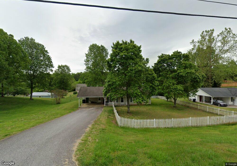
230 Laurel Ave Demorest, GA 30535
Estimated Value: $245,615 - $268,000
3
Beds
2
Baths
1,250
Sq Ft
$206/Sq Ft
Est. Value
About This Home
This home is located at 230 Laurel Ave, Demorest, GA 30535 and is currently estimated at $256,904, approximately $205 per square foot. 230 Laurel Ave is a home located in Habersham County with nearby schools including Demorest Elementary School, Wilbanks Middle School, and Habersham Success Academy.
Ownership History
Date
Name
Owned For
Owner Type
Purchase Details
Closed on
Jun 10, 2025
Sold by
Gunn Johnny
Bought by
Gunn Johnny S
Current Estimated Value
Purchase Details
Closed on
Mar 9, 2021
Sold by
Gunn Pauline Estate
Bought by
Parkwood Rentals Llc
Purchase Details
Closed on
Nov 13, 2020
Sold by
Gunn Johnny
Bought by
Gunn Pauline
Purchase Details
Closed on
May 1, 2017
Sold by
Pauline
Bought by
Gunn Johnny
Purchase Details
Closed on
Jul 21, 2016
Bought by
Gunn Johnny and Gunn Pauline
Purchase Details
Closed on
Feb 1, 2006
Sold by
Not Provided
Bought by
Gunn Johnny Investments Iii
Create a Home Valuation Report for This Property
The Home Valuation Report is an in-depth analysis detailing your home's value as well as a comparison with similar homes in the area
Home Values in the Area
Average Home Value in this Area
Purchase History
| Date | Buyer | Sale Price | Title Company |
|---|---|---|---|
| Gunn Johnny S | -- | -- | |
| Parkwood Rentals Llc | $495,000 | -- | |
| Gunn Pauline | -- | -- | |
| Gunn Johnny | -- | -- | |
| Gunn Johnny | -- | -- | |
| Gunn Johnny Investments Iii | -- | -- |
Source: Public Records
Tax History
| Year | Tax Paid | Tax Assessment Tax Assessment Total Assessment is a certain percentage of the fair market value that is determined by local assessors to be the total taxable value of land and additions on the property. | Land | Improvement |
|---|---|---|---|---|
| 2025 | $2,742 | $87,561 | $15,519 | $72,042 |
| 2024 | $1,841 | $70,944 | $11,020 | $59,924 |
| 2023 | $1,513 | $60,524 | $11,020 | $49,504 |
| 2022 | $1,336 | $51,244 | $8,816 | $42,428 |
| 2021 | $1,002 | $38,384 | $2,296 | $36,088 |
| 2020 | $902 | $33,524 | $2,536 | $30,988 |
| 2019 | $903 | $33,524 | $2,536 | $30,988 |
| 2018 | $896 | $33,524 | $2,536 | $30,988 |
| 2017 | $812 | $30,240 | $2,028 | $28,212 |
| 2016 | $789 | $75,600 | $2,028 | $28,212 |
| 2015 | -- | $75,600 | $2,028 | $28,212 |
| 2014 | $774 | $73,700 | $2,028 | $27,452 |
| 2013 | -- | $29,480 | $2,028 | $27,452 |
Source: Public Records
Map
Nearby Homes
- 150 Tennessee St
- 314 Holley St
- 545 Wauka Dr
- 274 & 278 N Hazel Ave
- 451 Spiral Hills Dr
- 646 Bald Ridge Cir
- 642 Bald Ridge Cir
- 660 Bald Ridge Cir
- 668 Bald Ridge Cir
- 623 Maine St
- 152 Eastside Dr
- 150 Kentucky Dr Unit A&B
- 151 Ivy St
- 101 Long St
- 1562 Central Ave
- 834 Hancock Rd
- 4444 State Highway 365
- 180 Springbrook Dr
- 114 Springbrook Dr
- 140 Kim Loop
- 202 Laurel Ave
- 307 Hickory Ave
- 199 Laurel Ave
- 256 Laurel Ave
- 319 Hickory Ave
- 271 Hickory Ave
- 174 Laurel Ave
- 119 Oak Place
- 257 Hickory Ave
- 503 Chestnut Ave
- 327 Hickory Ave
- 143 Oak Place
- 290 Hickory Ave
- 274 Hickory Ave Unit 4
- 274 Hickory Ave
- 302 Hickory Ave Unit 302A
- 302 Hickory Ave
- 260 Hickory Ave
- 154 Florida St
- 229 Hickory Ave
Your Personal Tour Guide
Ask me questions while you tour the home.