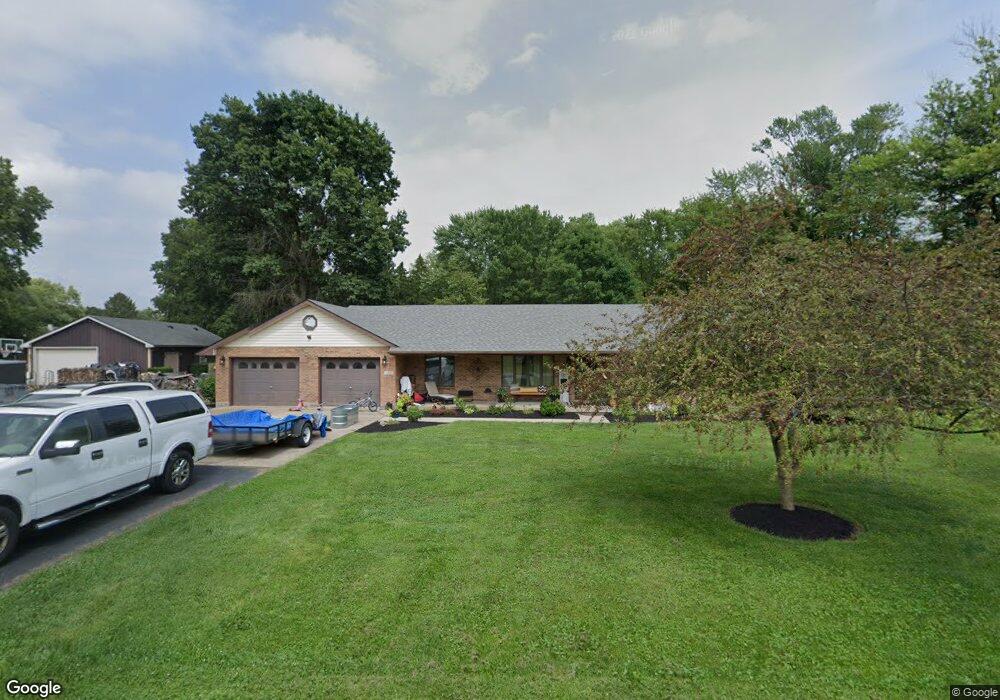
2300 S Union Rd Medway, OH 45341
Estimated Value: $249,000 - $389,000
3
Beds
2
Baths
2,283
Sq Ft
$148/Sq Ft
Est. Value
About This Home
This home is located at 2300 S Union Rd, Medway, OH 45341 and is currently estimated at $338,263, approximately $148 per square foot. 2300 S Union Rd is a home located in Clark County with nearby schools including Donnelsville Elementary School, Park Layne Elementary School, and New Carlisle Elementary School.
Ownership History
Date
Name
Owned For
Owner Type
Purchase Details
Closed on
Oct 22, 2012
Sold by
Bank Of New York Mellon
Bought by
Hobbs Misty A
Current Estimated Value
Home Financials for this Owner
Home Financials are based on the most recent Mortgage that was taken out on this home.
Original Mortgage
$145,053
Interest Rate
3.31%
Mortgage Type
VA
Purchase Details
Closed on
May 23, 2012
Sold by
Mccurry Jay C
Bought by
The Bank Of New York Mellon and The Bank Of New York As Successor To Jp
Purchase Details
Closed on
Jan 22, 2002
Sold by
Mccurry Jay C
Bought by
Mccurry Jay C and Mccurry Crystal L
Home Financials for this Owner
Home Financials are based on the most recent Mortgage that was taken out on this home.
Original Mortgage
$123,200
Interest Rate
7.16%
Create a Home Valuation Report for This Property
The Home Valuation Report is an in-depth analysis detailing your home's value as well as a comparison with similar homes in the area
Purchase History
| Date | Buyer | Sale Price | Title Company |
|---|---|---|---|
| Hobbs Misty A | $142,000 | Change Of Title Inc | |
| The Bank Of New York Mellon | $140,000 | None Available | |
| Mccurry Jay C | -- | -- | |
| Mccurry Jay C | $154,000 | -- |
Source: Public Records
Mortgage History
| Date | Status | Borrower | Loan Amount |
|---|---|---|---|
| Previous Owner | Hobbs Misty A | $145,053 | |
| Previous Owner | Mccurry Jay C | $123,200 |
Source: Public Records
Tax History
| Year | Tax Paid | Tax Assessment Tax Assessment Total Assessment is a certain percentage of the fair market value that is determined by local assessors to be the total taxable value of land and additions on the property. | Land | Improvement |
|---|---|---|---|---|
| 2025 | $4,590 | $115,550 | $17,470 | $98,080 |
| 2024 | $4,468 | $92,970 | $11,450 | $81,520 |
| 2023 | $4,468 | $92,970 | $11,450 | $81,520 |
| 2022 | $4,476 | $92,970 | $11,450 | $81,520 |
| 2021 | $3,763 | $71,460 | $8,740 | $62,720 |
| 2020 | $3,773 | $71,460 | $8,740 | $62,720 |
| 2019 | $3,878 | $71,460 | $8,740 | $62,720 |
| 2018 | $3,358 | $58,490 | $8,740 | $49,750 |
| 2017 | $3,337 | $58,489 | $8,736 | $49,753 |
| 2016 | $3,200 | $58,489 | $8,736 | $49,753 |
| 2015 | $3,006 | $53,018 | $8,736 | $44,282 |
| 2014 | $2,989 | $53,018 | $8,736 | $44,282 |
| 2013 | $2,995 | $53,018 | $8,736 | $44,282 |
Source: Public Records
Map
Nearby Homes
- 21 Medway Dr
- 19 University Rd
- 1368 Beach Dr
- 29 Dogwood Rd
- 9475 W National Rd
- 122 Lake Shore Dr
- 4600 Snider Rd
- 922 Styer Dr
- 489 Caldwell Cir
- 752 Hedwick St
- 745 Hedwick St
- 144 Stratmore St
- 1118 Chalet Ave
- 202 Braun St
- 831 Weinland Dr
- 469 Bischoff Rd
- 7992 W National Rd
- 5055 Hahn Ave
- 2151 Willow Run Cir Unit 2151
- 6 Danzig Ln
- 2278 S Union Rd
- 2219 S Union Rd
- 9597 Lower Valley Pike
- 1592 S Union Rd
- 1530 S Union Rd
- 9625 Lower Valley Pike
- 9504 Lower Valley Pike
- 9571 Lower Valley Pike
- 9470 Lower Valley Pike
- 9538 Lower Valley Pike
- 9558 Lower Valley Pike
- 9578 Lower Valley Pike
- 9517 Lower Valley Pike
- 9541 Lower Valley Pike
- 9439 Lower Valley Pike
- 9440 Lower Valley Pike
- 9485 Lower Valley Pike
- 9612 Lower Valley Pike
- 9673 Lower Valley Pike
- 9517 Lower Valley
Your Personal Tour Guide
Ask me questions while you tour the home.