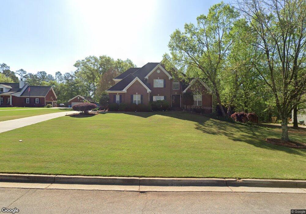
231 Brookstone Dr McDonough, GA 30252
Estimated Value: $513,000 - $590,000
6
Beds
5
Baths
3,059
Sq Ft
$180/Sq Ft
Est. Value
About This Home
This home is located at 231 Brookstone Dr, McDonough, GA 30252 and is currently estimated at $549,798, approximately $179 per square foot. 231 Brookstone Dr is a home located in Henry County with nearby schools including East Lake Elementary School, Union Grove Middle School, and Union Grove High School.
Ownership History
Date
Name
Owned For
Owner Type
Purchase Details
Closed on
Jun 22, 2016
Sold by
Johnson Rickie L
Bought by
Garcia James D and Garcia Monika A
Current Estimated Value
Home Financials for this Owner
Home Financials are based on the most recent Mortgage that was taken out on this home.
Original Mortgage
$301,500
Outstanding Balance
$240,506
Interest Rate
3.64%
Mortgage Type
New Conventional
Estimated Equity
$309,292
Purchase Details
Closed on
Feb 22, 2008
Sold by
Nama Robert
Bought by
Johnson Dawn and Johnson Rickie L
Home Financials for this Owner
Home Financials are based on the most recent Mortgage that was taken out on this home.
Original Mortgage
$351,116
Interest Rate
5.65%
Mortgage Type
VA
Purchase Details
Closed on
Nov 14, 2003
Sold by
Nama Homes Inc
Bought by
Nama Robert
Home Financials for this Owner
Home Financials are based on the most recent Mortgage that was taken out on this home.
Original Mortgage
$200,000
Interest Rate
5.5%
Mortgage Type
New Conventional
Create a Home Valuation Report for This Property
The Home Valuation Report is an in-depth analysis detailing your home's value as well as a comparison with similar homes in the area
Home Values in the Area
Average Home Value in this Area
Purchase History
| Date | Buyer | Sale Price | Title Company |
|---|---|---|---|
| Garcia James D | $335,000 | -- | |
| Johnson Dawn | $339,900 | -- | |
| Nama Robert | $250,000 | -- |
Source: Public Records
Mortgage History
| Date | Status | Borrower | Loan Amount |
|---|---|---|---|
| Open | Garcia James D | $301,500 | |
| Previous Owner | Johnson Dawn | $351,116 | |
| Previous Owner | Nama Robert | $200,000 |
Source: Public Records
Tax History
| Year | Tax Paid | Tax Assessment Tax Assessment Total Assessment is a certain percentage of the fair market value that is determined by local assessors to be the total taxable value of land and additions on the property. | Land | Improvement |
|---|---|---|---|---|
| 2025 | $6,847 | $237,560 | $24,000 | $213,560 |
| 2024 | $6,847 | $210,040 | $24,000 | $186,040 |
| 2023 | $5,705 | $200,440 | $20,000 | $180,440 |
| 2022 | $5,382 | $165,400 | $20,000 | $145,400 |
| 2021 | $4,986 | $148,600 | $16,000 | $132,600 |
| 2020 | $4,814 | $141,280 | $12,000 | $129,280 |
| 2019 | $4,708 | $136,680 | $12,000 | $124,680 |
| 2018 | $4,583 | $131,360 | $12,000 | $119,360 |
| 2016 | $3,914 | $106,760 | $12,000 | $94,760 |
| 2015 | $3,991 | $105,920 | $10,000 | $95,920 |
| 2014 | $4,023 | $105,640 | $10,000 | $95,640 |
Source: Public Records
Map
Nearby Homes
- 407 River Forest Dr
- 200 Riverbrook Ct
- 419 Riverwalk Unit 4
- 157 Cooks Way
- 301 Clyde Ct
- 507 N Green Cir
- 963 Crumbley Rd
- 170 Jaclaire Ln
- 891 Crumbley Rd
- 604 Clearwater Ct Unit 6
- 841 Streamside Dr
- 1261 Crumbley Rd
- 1085 Crown River Pkwy
- 451 Cotton Indian Creek Rd
- 1081 Crown River Pkwy
- 1004 Crown River Pkwy
- 760 Crumbley Rd
- 1523 Bent River Cir
- 1100 River Green Ct Unit 2
- 1064 Crown River Pkwy
- 229 Brookstone Dr
- 233 Brookstone Dr
- 201 Brookstone Dr
- 230 Brookstone Dr
- 232 Brookstone Dr
- 227 Brookstone Dr
- 235 Brookstone Dr
- 234 Brookstone Dr
- 200 Brookstone Dr
- 207 Brookstone Dr
- 215 Brookstone Dr
- 228 Brookstone Dr
- 202 Brookstone Dr
- 306 Riverbrook Ln
- 226 Brookstone Dr
- 307 Riverbrook Ln
- 220 Brookstone Dr
- 206 Brookstone Dr
- 1278 Crumbley Rd
- 222 Brookstone Dr
Your Personal Tour Guide
Ask me questions while you tour the home.