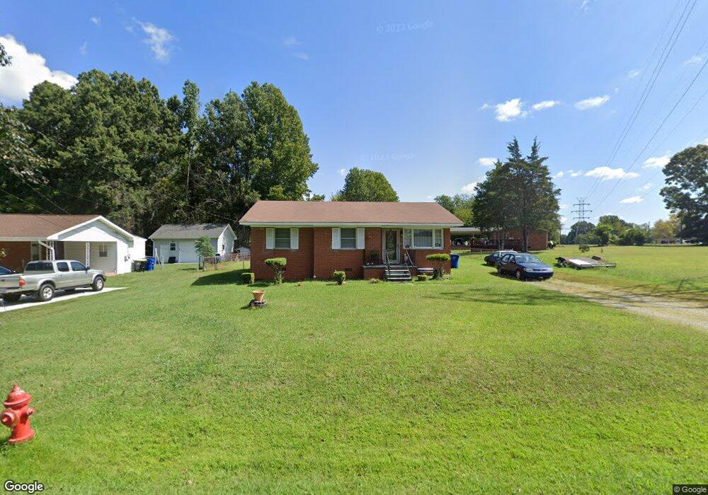
2336 Carter Rd Green Level, NC 27217
Estimated Value: $156,000 - $218,000
3
Beds
1
Bath
1,046
Sq Ft
$177/Sq Ft
Est. Value
About This Home
This home is located at 2336 Carter Rd, Green Level, NC 27217 and is currently estimated at $185,445, approximately $177 per square foot. 2336 Carter Rd is a home located in Alamance County with nearby schools including Haw River Elementary School, Woodlawn Middle School, and Eastern Alamance High School.
Ownership History
Date
Name
Owned For
Owner Type
Purchase Details
Closed on
Jun 7, 2018
Sold by
Bruce Berthene and Poteat James A
Bought by
Poteat Darius S
Current Estimated Value
Home Financials for this Owner
Home Financials are based on the most recent Mortgage that was taken out on this home.
Original Mortgage
$80,000
Outstanding Balance
$69,187
Interest Rate
4.5%
Estimated Equity
$116,258
Purchase Details
Closed on
Jul 9, 1993
Bought by
Poteat Vernon
Create a Home Valuation Report for This Property
The Home Valuation Report is an in-depth analysis detailing your home's value as well as a comparison with similar homes in the area
Home Values in the Area
Average Home Value in this Area
Purchase History
| Date | Buyer | Sale Price | Title Company |
|---|---|---|---|
| Poteat Darius S | $80,000 | Attorney | |
| Poteat Vernon | -- | -- |
Source: Public Records
Mortgage History
| Date | Status | Borrower | Loan Amount |
|---|---|---|---|
| Open | Poteat Darius S | $80,000 |
Source: Public Records
Tax History
| Year | Tax Paid | Tax Assessment Tax Assessment Total Assessment is a certain percentage of the fair market value that is determined by local assessors to be the total taxable value of land and additions on the property. | Land | Improvement |
|---|---|---|---|---|
| 2025 | $1,062 | $125,574 | $19,262 | $106,312 |
| 2024 | $1,031 | $125,574 | $19,262 | $106,312 |
| 2023 | $979 | $125,574 | $19,262 | $106,312 |
| 2022 | $744 | $65,265 | $13,060 | $52,205 |
| 2021 | $750 | $65,265 | $13,060 | $52,205 |
| 2020 | $757 | $65,265 | $13,060 | $52,205 |
| 2019 | $742 | $63,688 | $13,060 | $50,628 |
| 2018 | $0 | $63,688 | $13,060 | $50,628 |
| 2017 | $681 | $63,688 | $13,060 | $50,628 |
| 2016 | $854 | $79,417 | $19,590 | $59,827 |
| 2015 | $849 | $79,417 | $19,590 | $59,827 |
| 2014 | -- | $79,417 | $19,590 | $59,827 |
Source: Public Records
Map
Nearby Homes
- 0 Mount Vernon Rd
- 2516 Evergreen Ave
- 2234D Basil Holt Rd
- 2813 Otter Creek Trail
- 211 Sumter Ct
- 720 Roxboro St
- 284 Donelson Way
- 134 Pillow Ln
- 635 Keck Rd
- 2200 State Highway 49
- 3229 Labrador Dr
- 3082 Cascade Dr
- 8 Lea Ln
- 4 Lea Ln
- 148 N State St
- 103 Taylor St
- 1268 Quaker Lake Trail
- 2070 Haw River Hopedale Rd
- 3490 Bason Rd
- 3516 Bason Rd
- 2330 Carter Rd
- 1520 N Nc Highway 49
- 1435 Albert St
- 1427 Albert St
- 1528 N Nc Highway 49
- 1534 N Nc Highway 49
- 1430 Albert St
- 1470 N Nc Highway 49
- 1419 Albert St
- 1420 Albert St
- 1544 N Nc Highway 49
- 1464 N Nc Highway 49
- 1413 Albert St
- 2304 Carter Rd
- 2303 Carter Rd
- 1521 State Highway 49
- 1521 N Nc Highway 49
- 1454 N Nc Highway 49
- 1414 Albert St
- 1454 State Highway 49
Your Personal Tour Guide
Ask me questions while you tour the home.