Estimated Value: $127,224 - $149,000
3
Beds
2
Baths
1,400
Sq Ft
$100/Sq Ft
Est. Value
About This Home
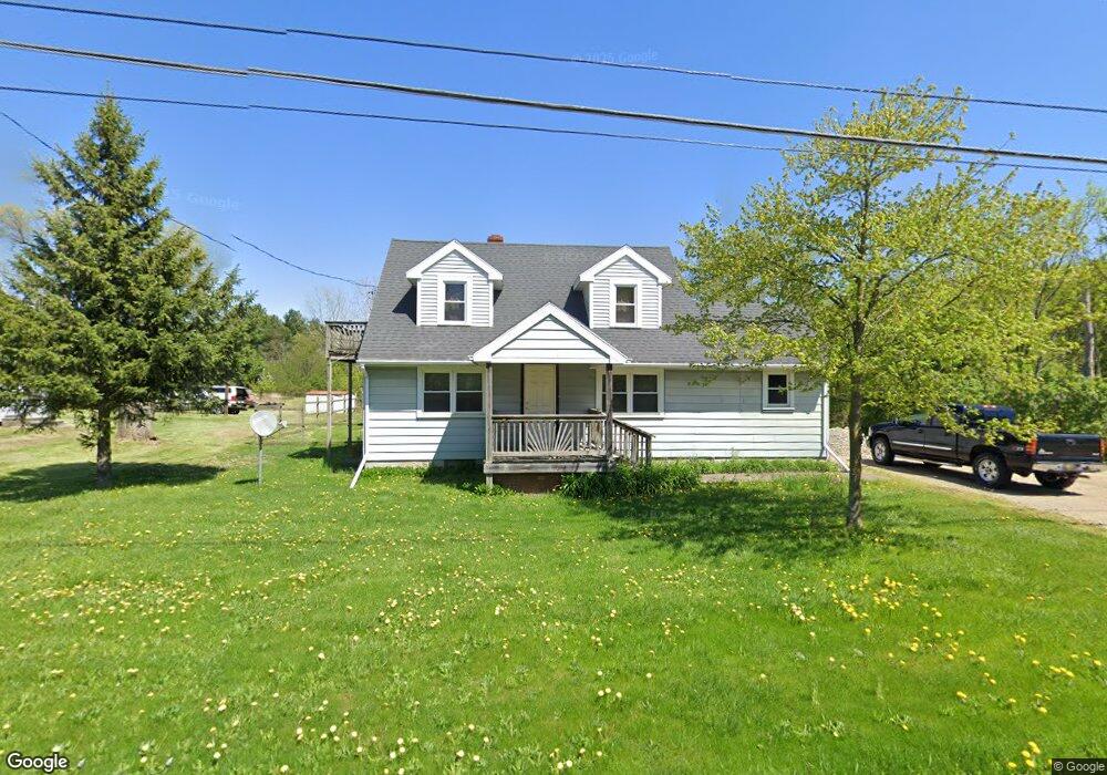
This home is located at 2381 S Dye Rd, Flint, MI 48532 and is currently estimated at $139,306, approximately $99 per square foot. 2381 S Dye Rd is a home located in Genesee County with nearby schools including Carman-Ainsworth High School, Genesee STEM Academy, and First Flint Seventh-day Adventist Christian School.
Ownership History
Date
Name
Owned For
Owner Type
Purchase Details
Closed on
Apr 20, 2010
Sold by
Hardy Randy J and Hardy Marla K
Bought by
Meyer John G
Current Estimated Value
Home Financials for this Owner
Home Financials are based on the most recent Mortgage that was taken out on this home.
Original Mortgage
$15,200
Outstanding Balance
$10,184
Interest Rate
5.12%
Mortgage Type
New Conventional
Estimated Equity
$129,122
Purchase Details
Closed on
Apr 23, 2008
Sold by
Suntrust Mortgage Inc
Bought by
Federal National Mortgage Association
Purchase Details
Closed on
Apr 16, 2008
Sold by
Clark Clyde N and Clark Kimberly A
Bought by
Suntrust Mortgage Inc
Create a Home Valuation Report for This Property
The Home Valuation Report is an in-depth analysis detailing your home's value as well as a comparison with similar homes in the area
Home Values in the Area
Average Home Value in this Area
Purchase History
We collect this data history from publicly available records. To have your information removed, we recommend requesting removal directly through your county’s website.
| Date | Buyer | Sale Price | Title Company |
|---|---|---|---|
| Meyer John G | $19,000 | Lawyers Title Insurance Corp | |
| Federal National Mortgage Association | -- | None Available | |
| Suntrust Mortgage Inc | $117,987 | None Available |
Source: Public Records
Mortgage History
We collect this data history from publicly available records. To have your information removed, we recommend requesting removal directly through your county’s website.
| Date | Status | Borrower | Loan Amount |
|---|---|---|---|
| Open | Meyer John G | $15,200 |
Source: Public Records
Tax History
| Year | Tax Paid | Tax Assessment Tax Assessment Total Assessment is a certain percentage of the fair market value that is determined by local assessors to be the total taxable value of land and additions on the property. | Land | Improvement |
|---|---|---|---|---|
| 2025 | $1,423 | $51,100 | $0 | $0 |
| 2024 | $716 | $48,500 | $0 | $0 |
| 2023 | $684 | $38,000 | $0 | $0 |
| 2022 | $637 | $33,400 | $0 | $0 |
| 2021 | $1,276 | $32,200 | $0 | $0 |
| 2020 | $614 | $31,200 | $0 | $0 |
| 2019 | $605 | $28,000 | $0 | $0 |
| 2018 | $1,165 | $33,500 | $0 | $0 |
| 2017 | $1,123 | $33,500 | $0 | $0 |
| 2016 | $1,150 | $28,800 | $0 | $0 |
| 2015 | $1,017 | $26,600 | $0 | $0 |
| 2014 | $603 | $25,500 | $0 | $0 |
| 2012 | -- | $29,300 | $29,300 | $0 |
Source: Public Records
Map
Nearby Homes
- 0 Mallison Ave Unit 20261021773
- 2356 S Dye Rd
- 2400 Marlene Dr
- 5200 Elko St
- 5151 Brobeck St
- 2176 Lauderdale St
- 2442 Valley Oaks Cir Unit 35
- 2281 Nandi Hills Trail
- 5227 Dania St
- 5323 Elmsford Dr
- 4490 W Lennon Rd
- 2052 S Dye Rd
- 1455 S Linden Rd
- 0 S Dye Rd
- 4335 Lennon Rd
- 0000 Reuben Reuben St
- 1468 Eggleston Ave
- 1460 S Dye Rd
- 10 Acres T A Mansour Blvd
- 4474 Corunna Rd
Your Personal Tour Guide
Ask me questions while you tour the home.