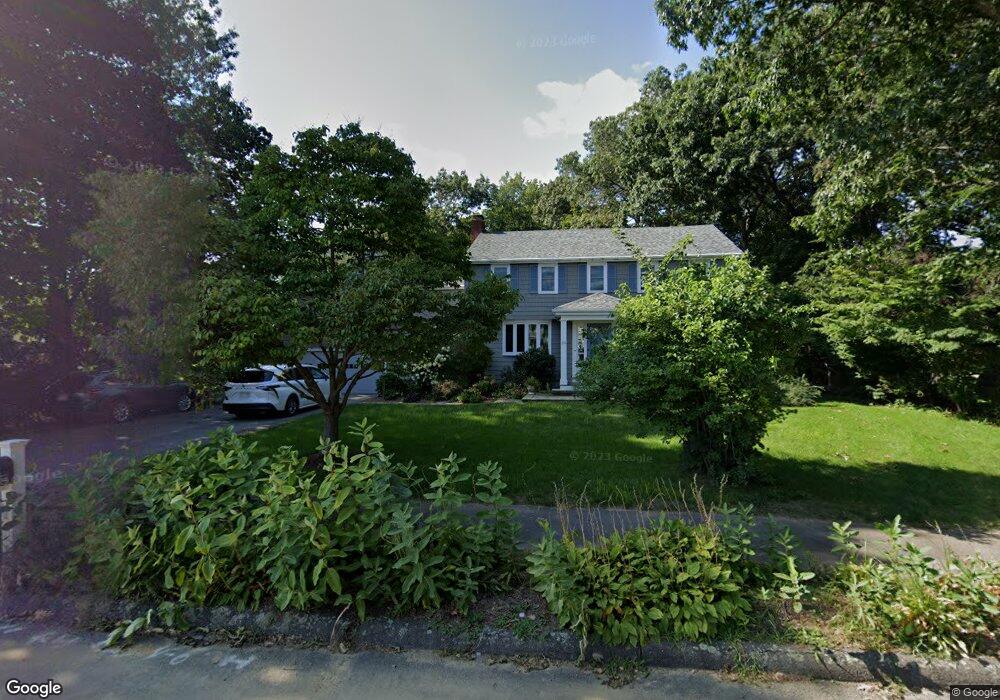
24 Mallard Dr Concord, MA 01742
Estimated Value: $1,382,000 - $1,630,000
About This Home
This home is located at 24 Mallard Dr, Concord, MA 01742 and is currently estimated at $1,504,737, approximately $526 per square foot. 24 Mallard Dr is a home located in Middlesex County with nearby schools including Alcott Elementary School, Concord Middle School, and Concord Carlisle High School.
Ownership History
We collect this data history from publicly available records. To have your information removed, we recommend requesting removal directly through your county’s website.
Purchase Details
Purchase Details
Purchase Details
Home Values in the Area
Average Home Value in this Area
Purchase History
We collect this data history from publicly available records. To have your information removed, we recommend requesting removal directly through your county’s website.
| Date | Buyer | Sale Price | Title Company |
|---|---|---|---|
| -- | None Available | ||
| -- | -- | ||
| $299,500 | -- |
Mortgage History
We collect this data history from publicly available records. To have your information removed, we recommend requesting removal directly through your county’s website.
| Date | Status | Borrower | Loan Amount |
|---|---|---|---|
| Previous Owner | $120,000 | ||
| Previous Owner | $150,000 | ||
| Previous Owner | $40,000 |
Tax History
We collect this data history from publicly available records. To have your information removed, we recommend requesting removal directly through your county’s website.
| Year | Tax Paid | Tax Assessment Tax Assessment Total Assessment is a certain percentage of the fair market value that is determined by local assessors to be the total taxable value of land and additions on the property. | Land | Improvement |
|---|---|---|---|---|
| 2025 | $171 | $1,289,100 | $592,500 | $696,600 |
| 2024 | $16,625 | $1,266,200 | $553,000 | $713,200 |
| 2023 | $15,626 | $1,205,700 | $526,700 | $679,000 |
| 2022 | $14,012 | $949,300 | $383,000 | $566,300 |
| 2021 | $13,522 | $918,600 | $383,000 | $535,600 |
| 2020 | $12,490 | $877,700 | $335,100 | $542,600 |
| 2019 | $11,993 | $845,200 | $343,900 | $501,300 |
| 2018 | $11,998 | $839,600 | $345,200 | $494,400 |
| 2017 | $10,271 | $730,000 | $328,700 | $401,300 |
| 2016 | $9,659 | $693,900 | $295,000 | $398,900 |
| 2015 | $9,679 | $677,300 | $312,200 | $365,100 |
Map
- 6 Parker Rd
- 16 Hatch Farm Ln
- 105 Prescott Rd
- 21 Clark Rd
- 6 Hillcrest Rd
- 51 Revolutionary Rd
- 50 Notre Dame Rd
- 1409 Monument St
- 38 Ripley Hill Rd
- 59 Martin Rd
- 1437-3 Monument St
- 152 Partridge Ln
- 105 Lexington Rd
- 70 Lexington Rd
- 215 Monument Farm Rd
- 210 Monument Farm Rd
- 106 Concord Rd
- 330 Lowell Rd
- 4 Abbott Ln
- 95 Hubbard St
- 32 Mallard Dr
- 85 Butternut Cir
- 99 Butternut Cir
- 42 Mallard Dr
- 5 Black Duck Rd
- 39 Mallard Dr
- 1 Fox Ln
- 100 Butternut Cir
- 74 Butternut Cir
- 58 Mallard Dr
- 17 Black Duck Rd
- 55 Butternut Cir
- 22 Black Duck Rd
- 25 Black Duck Rd
- 56 Butternut Cir
- 68 Mallard Dr
- 25 Fox Ln
- 59 Mallard Dr
- 65 Mallard Dr
- 45 Butternut Cir
Ask me questions while you tour the home.