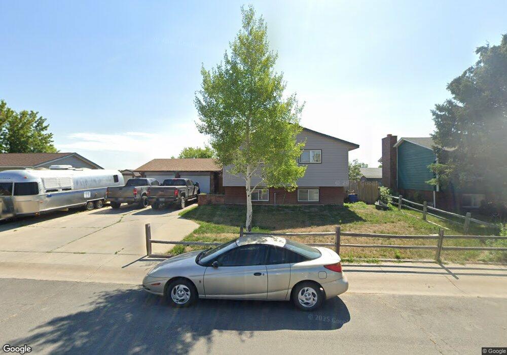
243 Bar Two Dr Douglas, WY 82633
Estimated Value: $278,000 - $348,000
2
Beds
2
Baths
1,140
Sq Ft
$264/Sq Ft
Est. Value
About This Home
This home is located at 243 Bar Two Dr, Douglas, WY 82633 and is currently estimated at $301,242, approximately $264 per square foot. 243 Bar Two Dr is a home located in Converse County with nearby schools including Douglas High School.
Ownership History
Date
Name
Owned For
Owner Type
Purchase Details
Closed on
May 4, 2021
Sold by
Swanson Jeffery P and Swanson Kwenna M
Bought by
Irwin Jennifer
Current Estimated Value
Home Financials for this Owner
Home Financials are based on the most recent Mortgage that was taken out on this home.
Original Mortgage
$191,468
Outstanding Balance
$172,497
Interest Rate
3%
Mortgage Type
FHA
Estimated Equity
$128,745
Purchase Details
Closed on
Sep 21, 2012
Sold by
Williams Bryon and Williams Debora
Bought by
Swanson Jeffrey P and Swanson Kwenna M
Create a Home Valuation Report for This Property
The Home Valuation Report is an in-depth analysis detailing your home's value as well as a comparison with similar homes in the area
Home Values in the Area
Average Home Value in this Area
Purchase History
| Date | Buyer | Sale Price | Title Company |
|---|---|---|---|
| Irwin Jennifer | -- | None Available | |
| Swanson Jeffrey P | -- | None Available |
Source: Public Records
Mortgage History
| Date | Status | Borrower | Loan Amount |
|---|---|---|---|
| Open | Irwin Jennifer | $191,468 | |
| Closed | Irwin Jennifer | $10,000 |
Source: Public Records
Tax History
| Year | Tax Paid | Tax Assessment Tax Assessment Total Assessment is a certain percentage of the fair market value that is determined by local assessors to be the total taxable value of land and additions on the property. | Land | Improvement |
|---|---|---|---|---|
| 2025 | $1,541 | $18,012 | $2,843 | $15,169 |
| 2024 | $1,541 | $23,230 | $3,791 | $19,439 |
| 2023 | $1,591 | $23,841 | $3,791 | $20,050 |
| 2022 | $1,424 | $21,187 | $3,610 | $17,577 |
| 2021 | $1,370 | $20,148 | $3,610 | $16,538 |
| 2020 | $1,314 | $19,694 | $3,610 | $16,084 |
| 2019 | $1,238 | $18,480 | $3,610 | $14,870 |
| 2018 | $1,164 | $17,684 | $3,610 | $14,074 |
| 2017 | $1,287 | $19,523 | $3,610 | $15,913 |
| 2015 | $1,292 | $19,653 | $3,574 | $16,079 |
| 2014 | $1,195 | $18,133 | $3,718 | $14,415 |
Source: Public Records
Map
Nearby Homes
- 217 S Windriver Dr
- 807 Leal St
- 930 Flicker St
- 935 Flicker St
- 0 S Riverbend Dr Unit 20231853
- 401 S Russell Lot 46 Ave
- 401 S Russell Lot 175 Ave
- 401 S Russell Lot 116 Ave
- 1901 Cold Springs Rd
- 1261 Sweetwater Rd
- 0 W Richards St
- 670 N Wind River Dr
- 1384 Sweetwater Rd
- 952 Eagle Dr
- 958 Eagle Dr
- 1102 N Riverbend Dr
- 981 Meadowlark Dr
- 1092 Riverbend Dr
- 1228 River View Ct
- 232 N 5th St
Your Personal Tour Guide
Ask me questions while you tour the home.