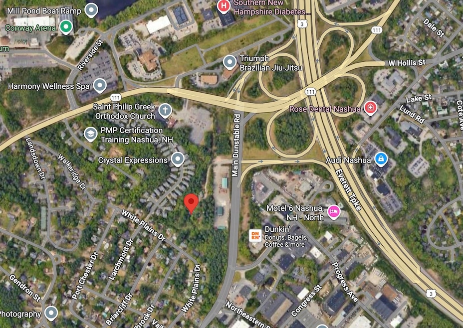
247 Main Dunstable Rd Nashua, NH 03062
West Hollis NeighborhoodEstimated payment $8,654/month
Highlights
- 5.06 Acre Lot
- Wooded Lot
- Timber
- Property is near public transit, schools, and shops
About This Lot
Over 5 acres in Nashua. Direct access to main Dunstable Road, with a lighted four-way intersection. Directly across from US Route 3 entrance.
Property Details
Property Type
- Land
Est. Annual Taxes
- $9,675
Lot Details
- 5.06 Acre Lot
- Property fronts a private road
- Sloped Lot
- Wooded Lot
- Property is zoned R9
Utilities
- 100 Amp Service
- Private Water Source
- Private Sewer
Additional Features
- Electricity Available at Street
- Property is near public transit, schools, and shops
- Timber
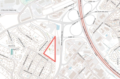
Map
Home Values in the Area
Average Home Value in this Area
Tax History
| Year | Tax Paid | Tax Assessment Tax Assessment Total Assessment is a certain percentage of the fair market value that is determined by local assessors to be the total taxable value of land and additions on the property. | Land | Improvement |
|---|---|---|---|---|
| 2025 | $10,542 | $626,400 | $261,900 | $364,500 |
| 2024 | $9,960 | $626,400 | $261,900 | $364,500 |
| 2023 | $9,675 | $530,700 | $209,500 | $321,200 |
| 2022 | $9,590 | $530,700 | $209,500 | $321,200 |
| 2021 | $9,490 | $408,700 | $165,300 | $243,400 |
| 2020 | $9,241 | $408,700 | $165,300 | $243,400 |
| 2019 | $8,893 | $408,700 | $165,300 | $243,400 |
| 2018 | $8,669 | $408,700 | $165,300 | $243,400 |
| 2017 | $7,755 | $300,700 | $148,900 | $151,800 |
| 2016 | $7,539 | $300,700 | $148,900 | $151,800 |
| 2015 | $7,376 | $300,700 | $148,900 | $151,800 |
| 2014 | $7,232 | $300,700 | $148,900 | $151,800 |
Property History
| Date | Event | Price | List to Sale | Price per Sq Ft |
|---|---|---|---|---|
| 01/12/2026 01/12/26 | Pending | -- | -- | -- |
| 10/01/2025 10/01/25 | For Sale | $1,450,000 | -- | -- |
Purchase History
We collect this data history from publicly available records. To have your information removed, we recommend requesting removal directly through your county’s website.
| Date | Type | Sale Price | Title Company |
|---|---|---|---|
| Warranty Deed | -- | -- | |
| Warranty Deed | -- | -- | |
| Warranty Deed | -- | -- |
Source: PrimeMLS
MLS Number: 5063731
APN: NASH-000000-000000-000015E
Disclaimer: Certain information contained herein is derived from information provided by parties other than Homes.com. All information provided is deemed reliable, but is not guaranteed to be accurate and should be independently verified.
![]() Copyright 2026 PrimeMLS, Inc. All rights reserved. This information is deemed reliable, but not guaranteed. The data relating to real estate displayed on this display comes in part from the IDX Program of PrimeMLS. The information being provided is for consumers’ personal, non-commercial use and may not be used for any purpose other than to identify prospective properties consumers may be interested in purchasing.
Copyright 2026 PrimeMLS, Inc. All rights reserved. This information is deemed reliable, but not guaranteed. The data relating to real estate displayed on this display comes in part from the IDX Program of PrimeMLS. The information being provided is for consumers’ personal, non-commercial use and may not be used for any purpose other than to identify prospective properties consumers may be interested in purchasing.
- 40 Hollow Ridge Dr
- 8 Althea Ln Unit U26
- 14 Dogwood Dr Unit U6
- 45 Dogwood Dr Unit U304
- 47 Dogwood Dr Unit U202
- 2 Jennifer Dr
- 12 Heather Ct Unit U39
- 4 Henry David Dr Unit 203
- 8 Kingston Dr
- 10 Cambridge Rd
- 22 Kern Dr
- 20-22 Joffre St
- 6 Nutmeg Dr
- 2 Freshwater Ct
- 165 Shore Dr
- 55 Spring Cove Rd Unit U136
- 11 Beaujolais Dr Unit U60
- 12 Fitzpatrick Cir Unit U81
- 13 Wakefield Dr
- 2 Lowther Place Unit U3

Ask me questions while you tour the home.