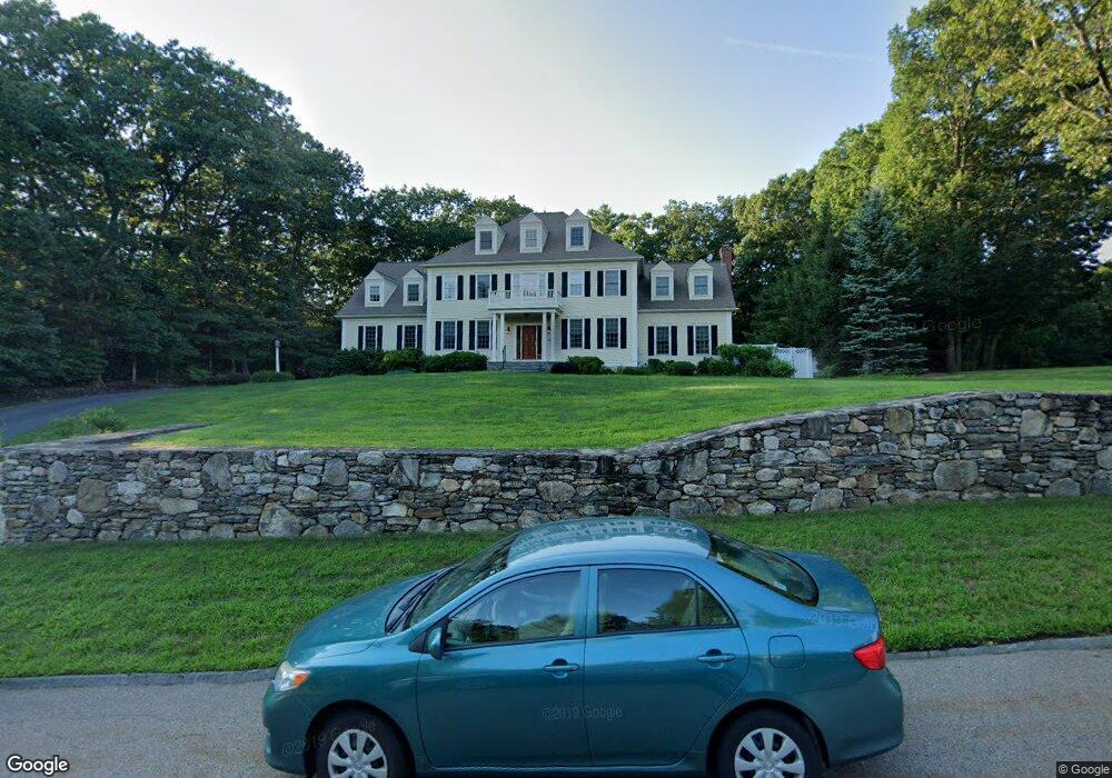
25 Crosswoods Path Walpole, MA 02081
Estimated Value: $1,678,433 - $2,074,000
5
Beds
4
Baths
4,533
Sq Ft
$410/Sq Ft
Est. Value
About This Home
This home is located at 25 Crosswoods Path, Walpole, MA 02081 and is currently estimated at $1,857,358, approximately $409 per square foot. 25 Crosswoods Path is a home located in Norfolk County with nearby schools including Fisher School, Walpole Middle School, and Walpole High School.
Ownership History
Date
Name
Owned For
Owner Type
Purchase Details
Closed on
Mar 10, 2023
Sold by
Poli Christopher J and Poli Rachel
Bought by
Poli Int
Current Estimated Value
Purchase Details
Closed on
Dec 7, 2001
Sold by
Jackie Rt
Bought by
Poli Christopher J and Poli Rachel
Create a Home Valuation Report for This Property
The Home Valuation Report is an in-depth analysis detailing your home's value as well as a comparison with similar homes in the area
Home Values in the Area
Average Home Value in this Area
Purchase History
| Date | Buyer | Sale Price | Title Company |
|---|---|---|---|
| Poli Int | -- | None Available | |
| Poli Christopher J | $462,500 | -- |
Source: Public Records
Tax History
| Year | Tax Paid | Tax Assessment Tax Assessment Total Assessment is a certain percentage of the fair market value that is determined by local assessors to be the total taxable value of land and additions on the property. | Land | Improvement |
|---|---|---|---|---|
| 2025 | $21,697 | $1,691,100 | $491,700 | $1,199,400 |
| 2024 | $20,866 | $1,578,400 | $473,400 | $1,105,000 |
| 2023 | $19,285 | $1,388,400 | $412,300 | $976,100 |
| 2022 | $17,497 | $1,210,000 | $381,000 | $829,000 |
| 2021 | $17,223 | $1,160,600 | $359,000 | $801,600 |
| 2020 | $16,207 | $1,081,200 | $350,000 | $731,200 |
| 2019 | $15,937 | $1,055,400 | $338,200 | $717,200 |
| 2018 | $16,212 | $1,061,700 | $322,800 | $738,900 |
| 2017 | $15,788 | $1,029,900 | $311,000 | $718,900 |
| 2016 | $15,644 | $1,005,400 | $320,800 | $684,600 |
| 2015 | $15,793 | $1,005,900 | $325,300 | $680,600 |
| 2014 | $15,133 | $960,200 | $325,300 | $634,900 |
Source: Public Records
Map
Nearby Homes
- 23 Crosswoods Path
- 28 Crosswoods Path
- 22 Crosswoods Path
- 22 Crosswoods Path
- 26 Crosswoods Path
- 16 Town Rd
- 19 Crosswoods Path
- 19 Crosswoods Path Unit 1
- 17 Crosswoods Path
- 24 Crosswoods Path
- 3 Starlight Dr
- 16 Starlight Dr
- 15 Crosswoods Path
- 33 Starlight Dr
- 11 Starlight Dr
- 12 Old Town Rd
- 16 Old Town Rd
- 18 Old Town Rd (Lot 18)
- 32 Starlight Dr
- 20 Crosswoods Path
Your Personal Tour Guide
Ask me questions while you tour the home.