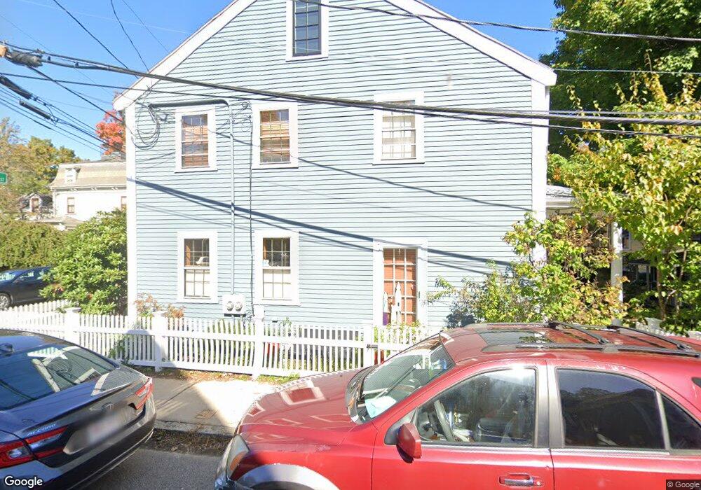
25 Thomas St Jamaica Plain, MA 02130
Jamaica Plain NeighborhoodEstimated Value: $983,000 - $1,118,000
2
Beds
2
Baths
1,796
Sq Ft
$590/Sq Ft
Est. Value
About This Home
This home is located at 25 Thomas St, Jamaica Plain, MA 02130 and is currently estimated at $1,059,136, approximately $589 per square foot. 25 Thomas St is a home located in Suffolk County with nearby schools including Neighborhood School, The Croft School - Jamaica Plain, and Meridian Academy.
Ownership History
Date
Name
Owned For
Owner Type
Purchase Details
Closed on
Apr 12, 2006
Sold by
Biegelsen Elizabeth S
Bought by
Dryden-Peterson Sarah and Dryden-Peterson Scott
Current Estimated Value
Home Financials for this Owner
Home Financials are based on the most recent Mortgage that was taken out on this home.
Original Mortgage
$417,000
Outstanding Balance
$238,527
Interest Rate
6.28%
Mortgage Type
Purchase Money Mortgage
Estimated Equity
$820,609
Create a Home Valuation Report for This Property
The Home Valuation Report is an in-depth analysis detailing your home's value as well as a comparison with similar homes in the area
Home Values in the Area
Average Home Value in this Area
Purchase History
| Date | Buyer | Sale Price | Title Company |
|---|---|---|---|
| Dryden-Peterson Sarah | $540,000 | -- |
Source: Public Records
Mortgage History
| Date | Status | Borrower | Loan Amount |
|---|---|---|---|
| Open | Dryden-Peterson Sarah | $417,000 |
Source: Public Records
Tax History
| Year | Tax Paid | Tax Assessment Tax Assessment Total Assessment is a certain percentage of the fair market value that is determined by local assessors to be the total taxable value of land and additions on the property. | Land | Improvement |
|---|---|---|---|---|
| 2025 | $11,850 | $1,023,300 | $0 | $1,023,300 |
| 2024 | $10,157 | $931,800 | $0 | $931,800 |
| 2023 | $9,523 | $886,700 | $0 | $886,700 |
| 2022 | $9,102 | $836,600 | $0 | $836,600 |
| 2021 | $8,752 | $820,200 | $0 | $820,200 |
| 2020 | $8,351 | $790,800 | $0 | $790,800 |
| 2019 | $7,717 | $732,200 | $0 | $732,200 |
| 2018 | $7,524 | $717,900 | $0 | $717,900 |
| 2017 | $7,312 | $690,500 | $0 | $690,500 |
| 2016 | $7,165 | $651,400 | $0 | $651,400 |
| 2015 | $6,303 | $520,500 | $0 | $520,500 |
| 2014 | $6,007 | $477,500 | $0 | $477,500 |
Source: Public Records
Map
Nearby Homes
- 21 Starr Ln
- 55 South St Unit 3
- 51 Green St
- 60 Carolina Ave Unit 2
- 54 Orchard St Unit 2
- 26 Custer St Unit 2
- 76 Elm St Unit 114
- 76 Elm St Unit G3
- 68 Seaverns Ave Unit A
- 11-13 Parley Ave Unit 11B
- 584 Centre St
- 96 Seaverns Ave Unit 1
- 47R Jamaica St Unit 3
- 49 Jamaica St Unit 1
- 49 Jamaica St
- 49 Jamaica St Unit 2
- 55 Mcbride St Unit 2
- 58 Boynton St Unit 1
- 9 Pond St Unit 2
- 285 Lamartine St
- 8 Brewer St Unit 2
- 4 Brewer St
- 4 Brewer St Unit 1
- 4 Brewer St Unit 2
- 4 Brewer St Unit 3
- 21 Thomas St
- 10 Brewer St
- 10 Brewer St Unit 1
- 10 Brewer St
- 10 Brewer St Unit 2
- 10 Brewer St Unit 3
- 22 Thomas St
- 22 Thomas St Unit 1
- 22 Thomas St Unit 2
- 20 Thomas St
- 17 Thomas St Unit 19
- 17 Thomas St Unit 19
- 5 Brewer St
- 7 Brewer St
- 7 Brewer St Unit 1
Your Personal Tour Guide
Ask me questions while you tour the home.