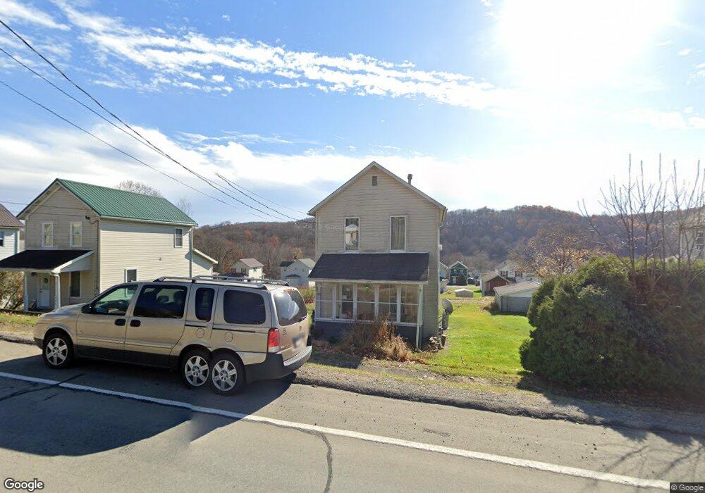
255 Main St Ernest, PA 15739
Estimated Value: $53,000 - $73,000
2
Beds
1
Bath
919
Sq Ft
$71/Sq Ft
Est. Value
About This Home
This home is located at 255 Main St, Ernest, PA 15739 and is currently estimated at $65,005, approximately $70 per square foot. 255 Main St is a home with nearby schools including Rayne Elementary School, W.A. McCreery Elementary School, and Marion Center Area Junior/Senior High School.
Ownership History
Date
Name
Owned For
Owner Type
Purchase Details
Closed on
Mar 1, 2023
Sold by
Bowser Stephen D
Bought by
Bowser Patricia and Maresh Dan
Current Estimated Value
Home Financials for this Owner
Home Financials are based on the most recent Mortgage that was taken out on this home.
Original Mortgage
$50,010
Outstanding Balance
$47,986
Interest Rate
6.15%
Mortgage Type
FHA
Estimated Equity
$17,019
Purchase Details
Closed on
Mar 30, 2021
Sold by
Bender Phillip
Bought by
Bowser Stephen D
Purchase Details
Closed on
Jan 8, 2016
Sold by
Bryson Cary A
Bought by
Bender Phillip
Home Financials for this Owner
Home Financials are based on the most recent Mortgage that was taken out on this home.
Original Mortgage
$19,200
Interest Rate
3.98%
Mortgage Type
New Conventional
Purchase Details
Closed on
Aug 16, 2005
Sold by
Plavi Cary A and Bryson Cary A
Bought by
Bryson Cary A and Bryson Scott Y
Create a Home Valuation Report for This Property
The Home Valuation Report is an in-depth analysis detailing your home's value as well as a comparison with similar homes in the area
Purchase History
We collect this data history from publicly available records. To have your information removed, we recommend requesting removal directly through your county’s website.
| Date | Buyer | Sale Price | Title Company |
|---|---|---|---|
| Bowser Patricia | $60,000 | Amrock | |
| Bowser Stephen D | $22,000 | None Available | |
| Bender Phillip | $24,000 | None Available | |
| Bryson Cary A | -- | None Available |
Source: Public Records
Mortgage History
We collect this data history from publicly available records. To have your information removed, we recommend requesting removal directly through your county’s website.
| Date | Status | Borrower | Loan Amount |
|---|---|---|---|
| Open | Bowser Patricia | $50,010 | |
| Previous Owner | Bender Phillip | $19,200 |
Source: Public Records
Tax History
| Year | Tax Paid | Tax Assessment Tax Assessment Total Assessment is a certain percentage of the fair market value that is determined by local assessors to be the total taxable value of land and additions on the property. | Land | Improvement |
|---|---|---|---|---|
| 2025 | $533 | $25,000 | $14,000 | $11,000 |
| 2024 | $511 | $25,000 | $14,000 | $11,000 |
| 2023 | $487 | $25,000 | $14,000 | $11,000 |
| 2022 | $482 | $25,000 | $14,000 | $11,000 |
| 2021 | $1,187 | $61,500 | $14,100 | $47,400 |
| 2020 | $1,133 | $61,500 | $14,100 | $47,400 |
| 2018 | $1,059 | $61,500 | $14,100 | $47,400 |
| 2017 | $1,059 | $61,500 | $14,100 | $47,400 |
| 2016 | -- | $61,500 | $14,100 | $47,400 |
| 2015 | -- | $3,970 | $580 | $3,390 |
| 2014 | -- | $3,970 | $580 | $3,390 |
Source: Public Records
Map
Nearby Homes
- 208 Republican Ln
- 57 Shick Dr
- 850 Martin Rd
- 1190 Old Route 119 Hwy N
- 617 College Lodge Rd
- 851 Zehner Rd
- 790 White Farm Rd
- 3940 & 3953 Groft Rd
- 401 N 5th St
- 360 N 8th St
- Lot #2 Hawk's Nest Cir
- Lot #1 Indian Hills Dr
- Lot #12 Hunter's Creek
- 839 Chestnut St
- 1180 Chestnut St
- 242 N 10th St
- 919 Oak St
- 303 N 3rd St
- 436 Oak St
- 1354 Water St
Your Personal Tour Guide
Ask me questions while you tour the home.