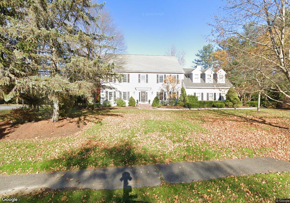
26 Atkinson Ln Sudbury, MA 01776
Estimated Value: $1,576,760 - $1,934,000
4
Beds
5
Baths
4,312
Sq Ft
$401/Sq Ft
Est. Value
About This Home
This home is located at 26 Atkinson Ln, Sudbury, MA 01776 and is currently estimated at $1,729,440, approximately $401 per square foot. 26 Atkinson Ln is a home located in Middlesex County with nearby schools including Peter Noyes Elementary School, Ephraim Curtis Middle School, and Lincoln-Sudbury Regional High School.
Ownership History
Date
Name
Owned For
Owner Type
Purchase Details
Closed on
Jul 25, 2014
Sold by
Sullivan Mark and Sullivan Marian A
Bought by
Tisdale Matthew and Tisdale Sandee
Current Estimated Value
Home Financials for this Owner
Home Financials are based on the most recent Mortgage that was taken out on this home.
Original Mortgage
$750,000
Outstanding Balance
$561,612
Interest Rate
4.18%
Mortgage Type
Purchase Money Mortgage
Estimated Equity
$1,167,828
Create a Home Valuation Report for This Property
The Home Valuation Report is an in-depth analysis detailing your home's value as well as a comparison with similar homes in the area
Home Values in the Area
Average Home Value in this Area
Purchase History
We collect this data history from publicly available records. To have your information removed, we recommend requesting removal directly through your county’s website.
| Date | Buyer | Sale Price | Title Company |
|---|---|---|---|
| Tisdale Matthew | $954,000 | -- | |
| Tisdale Matthew | $954,000 | -- |
Source: Public Records
Mortgage History
We collect this data history from publicly available records. To have your information removed, we recommend requesting removal directly through your county’s website.
| Date | Status | Borrower | Loan Amount |
|---|---|---|---|
| Open | Tisdale Matthew | $750,000 | |
| Closed | Tisdale Matthew | $750,000 | |
| Previous Owner | Tisdale Matthew | $138,000 |
Source: Public Records
Tax History
| Year | Tax Paid | Tax Assessment Tax Assessment Total Assessment is a certain percentage of the fair market value that is determined by local assessors to be the total taxable value of land and additions on the property. | Land | Improvement |
|---|---|---|---|---|
| 2025 | $22,950 | $1,567,600 | $546,500 | $1,021,100 |
| 2024 | $22,080 | $1,511,300 | $530,500 | $980,800 |
| 2023 | $20,419 | $1,294,800 | $473,700 | $821,100 |
| 2022 | $19,911 | $1,103,100 | $434,500 | $668,600 |
| 2021 | $18,753 | $995,900 | $434,500 | $561,400 |
| 2020 | $18,374 | $995,900 | $434,500 | $561,400 |
| 2019 | $17,693 | $987,900 | $434,500 | $553,400 |
| 2018 | $17,333 | $966,700 | $462,100 | $504,600 |
| 2017 | $16,965 | $956,300 | $457,700 | $498,600 |
| 2016 | $16,449 | $924,100 | $440,100 | $484,000 |
| 2015 | $15,185 | $862,800 | $436,100 | $426,700 |
| 2014 | $15,188 | $842,400 | $424,500 | $417,900 |
Source: Public Records
Map
Nearby Homes
- 51 Atkinson Ln
- 9 Priest Rd
- 30 Harness Ln
- 42 Pinewood Ave
- 17 Brentwood Rd
- 45 Webster Cir
- 26 Maplewood Ave
- 15 Ronald Rd
- 138 Fairbank Rd
- 59 Tanbark Rd
- 55 Saxony Dr
- 355 Maynard Rd
- 7 Saddle Ridge Rd
- 65 Fox Run Rd
- 11 Axdell Rd
- 55 Widow Rites Ln
- 64 Cudworth Ln
- 8 Twillingate Rd
- 228 Horse Pond Rd
- 71 Robert Best Rd
Your Personal Tour Guide
Ask me questions while you tour the home.