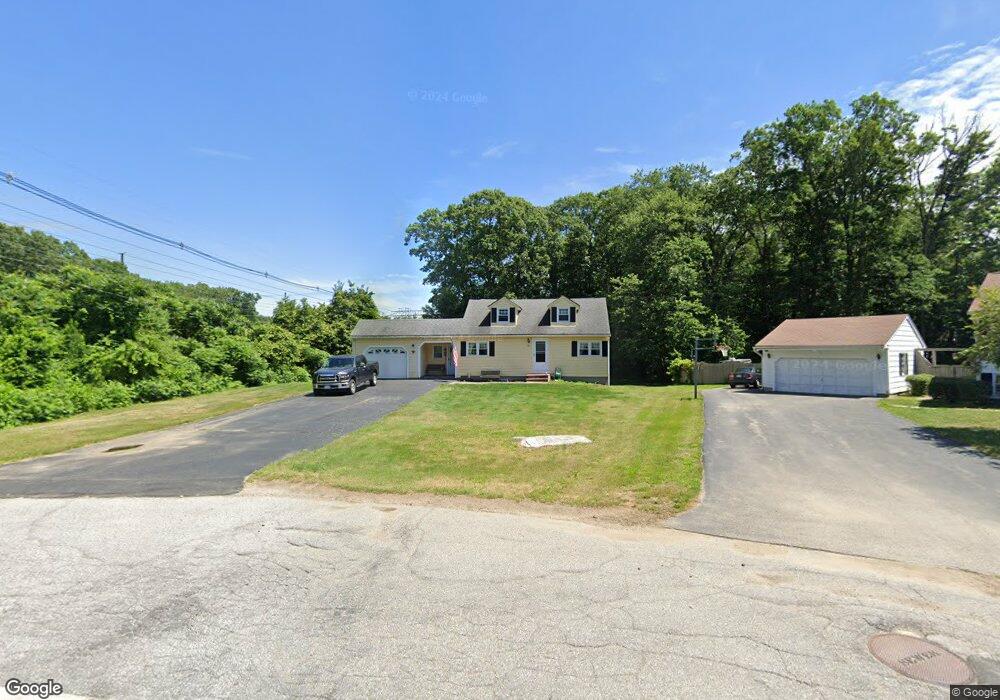
26 Carousel Dr Millbury, MA 01527
Estimated Value: $478,478 - $580,000
3
Beds
2
Baths
1,506
Sq Ft
$348/Sq Ft
Est. Value
About This Home
This home is located at 26 Carousel Dr, Millbury, MA 01527 and is currently estimated at $524,620, approximately $348 per square foot. 26 Carousel Dr is a home located in Worcester County with nearby schools including Elmwood Street Elementary School, Raymond E. Shaw Elementary School, and Millbury Junior/Senior High School.
Ownership History
Date
Name
Owned For
Owner Type
Purchase Details
Closed on
Jan 23, 2023
Sold by
Fox Kevin R
Bought by
Fox Kevin R and Fox Jennifer L
Current Estimated Value
Home Financials for this Owner
Home Financials are based on the most recent Mortgage that was taken out on this home.
Original Mortgage
$55,000
Outstanding Balance
$52,289
Interest Rate
6.33%
Mortgage Type
Credit Line Revolving
Estimated Equity
$472,331
Purchase Details
Closed on
Apr 28, 2000
Sold by
Kilmonis Peter P and Kilmonis Louise M
Bought by
Fox Kevin R
Home Financials for this Owner
Home Financials are based on the most recent Mortgage that was taken out on this home.
Original Mortgage
$119,000
Interest Rate
8.23%
Mortgage Type
Purchase Money Mortgage
Create a Home Valuation Report for This Property
The Home Valuation Report is an in-depth analysis detailing your home's value as well as a comparison with similar homes in the area
Home Values in the Area
Average Home Value in this Area
Purchase History
We collect this data history from publicly available records. To have your information removed, we recommend requesting removal directly through your county’s website.
| Date | Buyer | Sale Price | Title Company |
|---|---|---|---|
| Fox Kevin R | -- | None Available | |
| Fox Kevin R | -- | None Available | |
| Fox Kevin R | $140,000 | -- | |
| Fox Kevin R | $140,000 | -- |
Source: Public Records
Mortgage History
We collect this data history from publicly available records. To have your information removed, we recommend requesting removal directly through your county’s website.
| Date | Status | Borrower | Loan Amount |
|---|---|---|---|
| Open | Fox Kevin R | $55,000 | |
| Closed | Fox Kevin R | $55,000 | |
| Previous Owner | Fox Kevin R | $25,000 | |
| Previous Owner | Fox Kevin R | $121,000 | |
| Previous Owner | Fox Kevin R | $119,000 |
Source: Public Records
Tax History
| Year | Tax Paid | Tax Assessment Tax Assessment Total Assessment is a certain percentage of the fair market value that is determined by local assessors to be the total taxable value of land and additions on the property. | Land | Improvement |
|---|---|---|---|---|
| 2025 | $5,373 | $401,300 | $134,100 | $267,200 |
| 2024 | $4,928 | $372,500 | $124,100 | $248,400 |
| 2023 | $4,321 | $299,000 | $86,700 | $212,300 |
| 2022 | $4,214 | $280,900 | $86,700 | $194,200 |
| 2021 | $4,137 | $268,100 | $86,700 | $181,400 |
| 2020 | $12,410 | $261,700 | $86,700 | $175,000 |
| 2019 | $4,360 | $275,100 | $86,300 | $188,800 |
| 2018 | $11,427 | $262,300 | $86,300 | $176,000 |
| 2017 | $4,786 | $238,600 | $90,000 | $148,600 |
| 2016 | $10,555 | $224,300 | $90,000 | $134,300 |
| 2015 | $3,725 | $226,300 | $95,500 | $130,800 |
| 2014 | $3,663 | $214,200 | $95,500 | $118,700 |
Source: Public Records
Map
Nearby Homes
- 122 Elm St
- 7 Leslie Ln
- 63 Miles St
- 131 Elm St
- 121 Millbury Ave
- 3 Moore Dr
- 2 Wingfoot Ln
- 16 Herricks Ln
- 108 Worcester Providence Turnpike
- 2 Wilson Rd Unit B
- 124 Worcester Providence Turnpike
- 128 Worcester Providence Turnpike
- 0 Worcester Providence Turnpike
- 11 Elmwood Terrace Unit A
- 23 Upton St
- 20 Old Providence Rd
- 66 Buttonwood Ave
- 10 Logan's Run Unit 10
- 102 Lordvale Blvd
- 8 Alstead Path
Your Personal Tour Guide
Ask me questions while you tour the home.