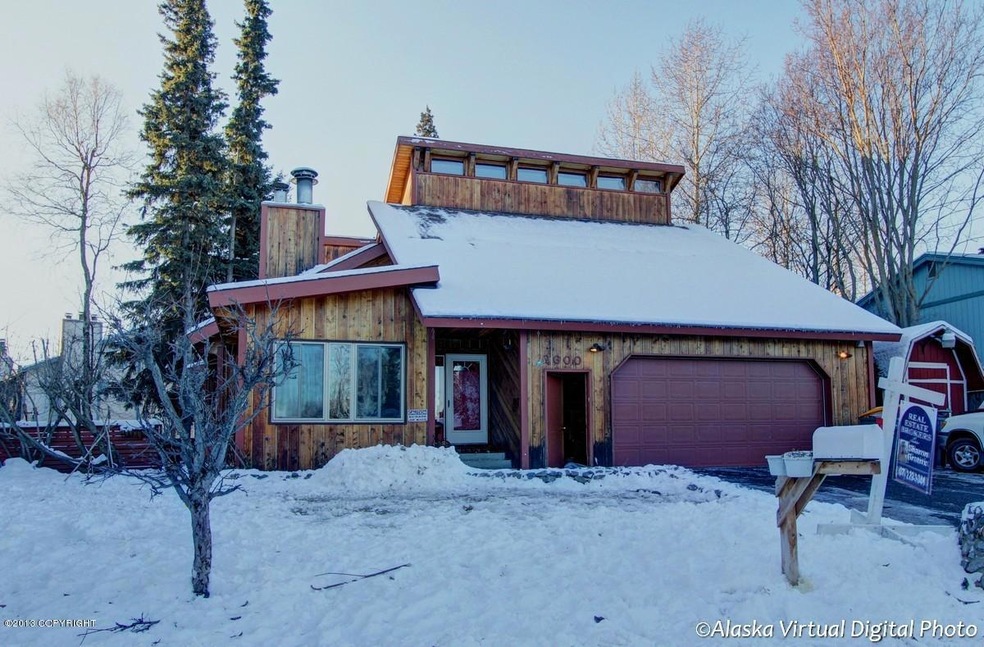

2600 Klamath Dr Anchorage, AK 99517
Spenard NeighborhoodEstimated Value: $456,000 - $742,677
Highlights
- Spa
- Sauna
- Wood Flooring
- West High School Rated A
- Deck
- Den
About This Home
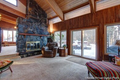
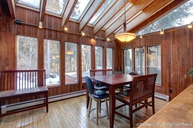
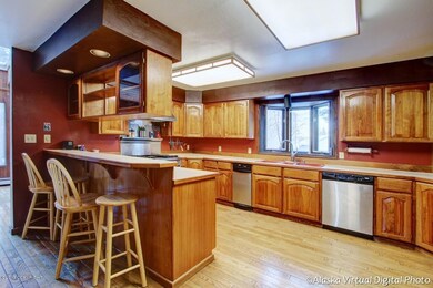
As of February 2014This house is a beautiful deceptively large family home. Beautiful kitchen, dining and living area. Lots of high ceilings, wood accents, great two sided fireplace out of Hope Slate on main level, Eklutna stone fireplace in large family room downstairs with bar. All bedrooms are huge and several bonus rooms for nursery or library or home office. Great deck and hot tub.
Home Details
Home Type
- Single Family
Year Built
- Built in 1983
Lot Details
- 8,276 Sq Ft Lot
- Fenced
- Property is zoned R1A, Single Family Residential
Parking
- 2 Car Attached Garage
- Attached Carport
- Open Parking
Home Design
- Block Exterior
Interior Spaces
- 4,799 Sq Ft Home
- Wet Bar
- Ceiling Fan
- Fireplace
- Family Room
- Den
- Sauna
- Finished Basement
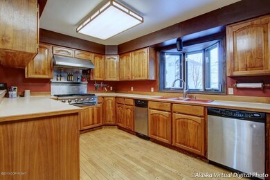
Kitchen
- Oven or Range
- Microwave
- Dishwasher
- Trash Compactor
- Disposal
Flooring
- Wood
- Carpet
Bedrooms and Bathrooms
- 5 Bedrooms
- 3 Full Bathrooms
- Spa Bath
Home Security
- Home Security System
- Fire and Smoke Detector
Outdoor Features
- Spa
- Deck
Schools
- Northwood Elementary School
- Romig Middle School
- West Anchorage High School
Utilities
- Baseboard Heating
- Electricity To Lot Line
Community Details
Listing and Financial Details
- Property Available on 1/1/14
- Tenant pays for cable TV, electricity, gas, sewer, trash collection, water, snow removal, grounds care
- 6 Month Lease Term
Ownership History
Purchase Details
Purchase Details
Home Financials for this Owner
Home Financials are based on the most recent Mortgage that was taken out on this home.Home Values in the Area
Average Home Value in this Area
Purchase History
| Date | Buyer | Sale Price | Title Company |
|---|---|---|---|
| Summit Legacy Services Llc | -- | Stewart Title Company | |
| Smith Scott P | -- | Pnt |
Mortgage History
| Date | Status | Borrower | Loan Amount |
|---|---|---|---|
| Previous Owner | Smith Scott P | $365,750 |
Property History
| Date | Event | Price | List to Sale | Price per Sq Ft |
|---|---|---|---|---|
| 02/18/2014 02/18/14 | Rented | -- | -- | -- |
| 02/18/2014 02/18/14 | Under Contract | -- | -- | -- |
| 11/19/2013 11/19/13 | For Rent | $3,600 | -- | -- |
Tax History
| Year | Tax Paid | Tax Assessment Tax Assessment Total Assessment is a certain percentage of the fair market value that is determined by local assessors to be the total taxable value of land and additions on the property. | Land | Improvement |
|---|---|---|---|---|
| 2025 | $10,515 | $747,900 | $106,300 | $641,600 |
| 2024 | $10,515 | $726,300 | $106,300 | $620,000 |
| 2023 | $11,466 | $673,300 | $106,300 | $567,000 |
| 2022 | $10,434 | $669,600 | $106,300 | $563,300 |
| 2021 | $11,003 | $610,600 | $106,300 | $504,300 |
| 2020 | $9,348 | $600,200 | $106,300 | $493,900 |
| 2019 | $9,122 | $607,600 | $106,300 | $501,300 |
| 2018 | $9,064 | $602,700 | $106,300 | $496,400 |
| 2017 | $9,308 | $614,400 | $106,300 | $508,100 |
| 2016 | $8,431 | $618,300 | $105,000 | $513,300 |
| 2015 | $8,431 | $569,500 | $105,000 | $464,500 |
| 2014 | $8,431 | $597,900 | $105,000 | $492,900 |
Map
Source: Alaska Multiple Listing Service
MLS Number: 13-16436
APN: 01031327000
Disclaimer: Certain information contained herein is derived from information provided by parties other than Homes.com. All information provided is deemed reliable, but is not guaranteed to be accurate and should be independently verified.
![]() The listing content relating to real estate for sale on this web site comes in part from the IDX Program of Alaska Multiple Listing Service, Inc. (AK MLS). Real estate listings held by brokerage firms other than Ten-X are marked with either the listing brokerage’s logo or the AK MLS logo and information about them includes the name of the listing brokerage. All information is deemed reliable but is not guaranteed and should be independently verified for accuracy. Copyright 2026 Alaska Multiple Listing Service, Inc. All rights reserved.
The listing content relating to real estate for sale on this web site comes in part from the IDX Program of Alaska Multiple Listing Service, Inc. (AK MLS). Real estate listings held by brokerage firms other than Ten-X are marked with either the listing brokerage’s logo or the AK MLS logo and information about them includes the name of the listing brokerage. All information is deemed reliable but is not guaranteed and should be independently verified for accuracy. Copyright 2026 Alaska Multiple Listing Service, Inc. All rights reserved.
- 2815 W International Airport Rd Unit B204
- 2515 Aspen Dr
- 4302 Forrest Rd
- 4420 Van Buren St
- 4011 Turnagain Blvd E
- 3333 Lakeshore Dr Unit 2
- 3333 Lakeshore Dr Unit 5
- NHN Northwood Dr
- 5000 Northwood Dr
- 1808 W 47th Ave
- 4000 Iowa Dr
- 6017 Collins Way
- 6283 Blackberry St
- 3223 W 62nd Ave
- 3830 Crosson Cir
- 4306 Hayes St
- 4300 Hayes St
- 2724 W 65th Ave
- 1200 Southampton Dr
- 3517 Vintage Cir
- 2610 Klamath Dr
- 2831 W Intl Airport Rd
- 2831 W Intl Airport Rd
- 2831 W Intl Airport Rd
- 2831 W Intl Airport Rd
- 2831 W Intl Airport Rd
- 2831 W Intl Airport Rd
- 2831 W Intl Airport Rd
- 2831 W Intl Airport Rd
- 2831 W Intl Airport Rd
- 2831 W Intl Airport Rd
- 2831 W Intl Airport Rd
- 2831 W Intl Airport Rd
- 2831 W International Airport Rd Unit F303
- 2831 W International Airport Rd
- 2831 W International Airport Rd Unit F302
- 2831 W International Airport Rd Unit F304
- 2831 W International Airport Rd Unit F301
- 2831 W International Airport Rd Unit F202
- 2831 W International Airport Rd Unit F203
Ask me questions while you tour the home.