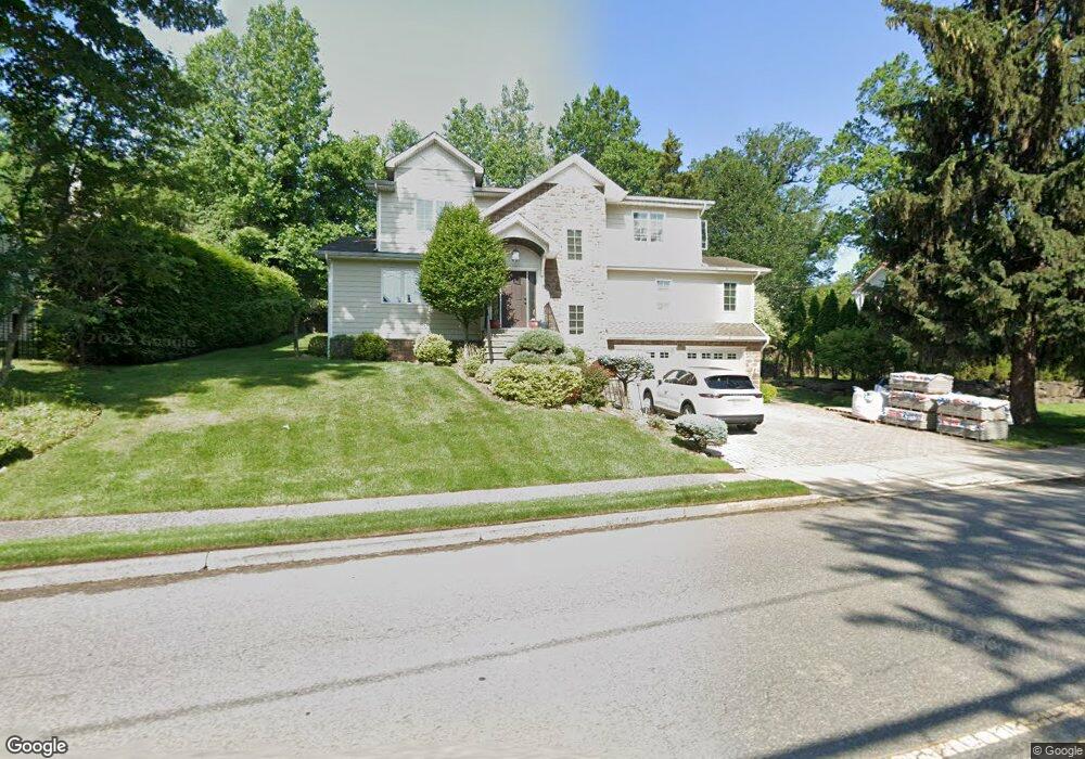
261 Brookside Ave Cresskill, NJ 07626
Estimated Value: $1,306,086 - $1,918,000
Studio
--
Bath
2,561
Sq Ft
$594/Sq Ft
Est. Value
About This Home
This home is located at 261 Brookside Ave, Cresskill, NJ 07626 and is currently estimated at $1,520,522, approximately $593 per square foot. 261 Brookside Ave is a home located in Bergen County with nearby schools including Cresskill High School.
Ownership History
Date
Name
Owned For
Owner Type
Purchase Details
Closed on
Oct 25, 2015
Sold by
Choi Sunghoon
Bought by
Eunjung Choi Sunghoon and Eunjung Leechoi
Current Estimated Value
Purchase Details
Closed on
Sep 8, 2010
Sold by
Refined Homes Llc
Bought by
Choi Sunghoon
Home Financials for this Owner
Home Financials are based on the most recent Mortgage that was taken out on this home.
Original Mortgage
$652,000
Outstanding Balance
$431,409
Interest Rate
4.48%
Mortgage Type
Purchase Money Mortgage
Estimated Equity
$1,089,113
Purchase Details
Closed on
Dec 18, 2009
Sold by
Rolli Rodica
Bought by
Refined Homes Llc
Create a Home Valuation Report for This Property
The Home Valuation Report is an in-depth analysis detailing your home's value as well as a comparison with similar homes in the area
Home Values in the Area
Average Home Value in this Area
Purchase History
| Date | Buyer | Sale Price | Title Company |
|---|---|---|---|
| Eunjung Choi Sunghoon | -- | Attorney | |
| Choi Sunghoon | $815,000 | -- | |
| Refined Homes Llc | $275,000 | -- |
Source: Public Records
Mortgage History
| Date | Status | Borrower | Loan Amount |
|---|---|---|---|
| Open | Choi Sunghoon | $652,000 |
Source: Public Records
Tax History
| Year | Tax Paid | Tax Assessment Tax Assessment Total Assessment is a certain percentage of the fair market value that is determined by local assessors to be the total taxable value of land and additions on the property. | Land | Improvement |
|---|---|---|---|---|
| 2025 | $20,615 | $955,900 | $388,600 | $567,300 |
| 2024 | $19,914 | $896,300 | $348,400 | $547,900 |
| 2023 | $19,571 | $858,000 | $323,400 | $534,600 |
| 2022 | $19,571 | $813,100 | $298,300 | $514,800 |
| 2021 | $19,219 | $787,000 | $285,800 | $501,200 |
| 2020 | $18,756 | $771,200 | $277,300 | $493,900 |
| 2019 | $18,300 | $760,300 | $273,800 | $486,500 |
| 2018 | $12,697 | $753,100 | $270,800 | $482,300 |
| 2017 | $18,338 | $673,700 | $214,800 | $458,900 |
| 2016 | $17,792 | $673,700 | $214,800 | $458,900 |
| 2015 | $17,240 | $673,700 | $214,800 | $458,900 |
| 2014 | $16,721 | $673,700 | $214,800 | $458,900 |
Source: Public Records
Map
Nearby Homes
- 32 Woodland Rd
- 251 Brookside Ave
- 3 Ridge Rd
- 1 Ridge Rd
- 28 Woodland Rd
- 258 Brookside Ave
- 270 Brookside Ave
- 274 Brookside Ave
- 85 Mezzine Dr
- 5 Ridge Rd
- 24 Woodland Rd
- 231 Brookside Ave
- 285 Brookside Ave
- 35 Woodland Rd
- 282 Brookside Ave
- 242 Brookside Ave
- 4 Godfrey Place
- 12 Evans Rd
- 8 Evans Rd
- 4 Deacon Place
Your Personal Tour Guide
Ask me questions while you tour the home.