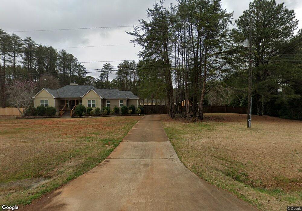
261 Stone Rd McDonough, GA 30253
Estimated Value: $293,000 - $314,000
About This Home
This home is located at 261 Stone Rd, McDonough, GA 30253 and is currently estimated at $301,917, approximately $191 per square foot. 261 Stone Rd is a home located in Henry County with nearby schools including Mount Carmel Elementary School, Hampton Middle School, and Hampton High School.
Ownership History
We collect this data history from publicly available records. To have your information removed, we recommend requesting removal directly through your county’s website.
Purchase Details
Home Financials for this Owner
Home Financials are based on the most recent Mortgage that was taken out on this home.Purchase Details
Home Values in the Area
Average Home Value in this Area
Purchase History
We collect this data history from publicly available records. To have your information removed, we recommend requesting removal directly through your county’s website.
| Date | Buyer | Sale Price | Title Company |
|---|---|---|---|
| $210,001 | -- | ||
| $23,000 | -- |
Mortgage History
We collect this data history from publicly available records. To have your information removed, we recommend requesting removal directly through your county’s website.
| Date | Status | Borrower | Loan Amount |
|---|---|---|---|
| Open | $199,500 |
Tax History
We collect this data history from publicly available records. To have your information removed, we recommend requesting removal directly through your county’s website.
| Year | Tax Paid | Tax Assessment Tax Assessment Total Assessment is a certain percentage of the fair market value that is determined by local assessors to be the total taxable value of land and additions on the property. | Land | Improvement |
|---|---|---|---|---|
| 2025 | $4,913 | $136,400 | $16,120 | $120,280 |
| 2024 | $4,913 | $128,520 | $14,880 | $113,640 |
| 2023 | $4,887 | $126,360 | $14,320 | $112,040 |
| 2022 | $3,724 | $96,040 | $13,240 | $82,800 |
| 2021 | $3,198 | $82,320 | $11,360 | $70,960 |
| 2020 | $657 | $73,560 | $10,680 | $62,880 |
| 2019 | $650 | $67,160 | $10,160 | $57,000 |
| 2018 | $648 | $62,160 | $9,360 | $52,800 |
| 2016 | $598 | $52,880 | $7,240 | $45,640 |
| 2015 | $564 | $48,040 | $7,680 | $40,360 |
| 2014 | -- | $40,240 | $7,680 | $32,560 |
Map
- 272 Stone Rd
- 1719 Highway 81 W
- 640 Newmorn Dr
- 128 Andrea Ln
- 365 New Morn Dr
- 335 New Morn Dr
- 1700 Rising View Cir
- 1533 Rolling Meadows Dr
- 490 Dorsey Rd
- 461 Arbor Chase
- 917 Ivy Brook Ct
- 112 Dorsey Springs Dr
- 1423 Trellis Ct Unit LOT 10
- 1397 Trellis Ct Unit LOT 15
- 1393 Trellis Ct Unit LOT 16
- 1410 Trellis Ct Unit LOT 20
- 1400 Trellis Ct Unit LOT 18
- 705 Trellis Ct
- 169 Manley Dr
- 620 Ivy Cove
- 75 Stone Rd
- 251 Stone Rd
- 281 Stone Rd
- 95 Stone Rd
- 85 Stone Rd
- 65 Stone Rd
- 241 Stone Rd
- 271 S Cleveland Church Rd
- 70 Stone Rd
- 70 Stone Rd
- 301 Stone Rd
- 78 Stone Rd
- 270 S Cleveland Church Rd
- 66 Stone Rd
- 74 Stone Rd
- 120 Stone Rd
- 282 Stone Rd
- 257 S Cleveland Church Rd
- 262 Stone Rd
- 228 S Cleveland Church Rd
Ask me questions while you tour the home.