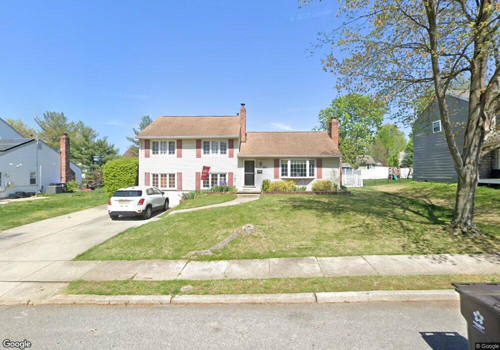
262 Burning Tree Rd Delran, NJ 08075
Tenby Chase NeighborhoodEstimated Value: $470,671 - $488,000
About This Home
This home is located at 262 Burning Tree Rd, Delran, NJ 08075 and is currently estimated at $477,918, approximately $276 per square foot. 262 Burning Tree Rd is a home located in Burlington County with nearby schools including Millbridge Elementary School, Delran Intermediate School, and Delran Middle School.
Ownership History
We collect this data history from publicly available records. To have your information removed, we recommend requesting removal directly through your county’s website.
Purchase Details
Home Financials for this Owner
Home Financials are based on the most recent Mortgage that was taken out on this home.Purchase Details
Home Financials for this Owner
Home Financials are based on the most recent Mortgage that was taken out on this home.Home Values in the Area
Average Home Value in this Area
Purchase History
We collect this data history from publicly available records. To have your information removed, we recommend requesting removal directly through your county’s website.
| Date | Buyer | Sale Price | Title Company |
|---|---|---|---|
| $279,900 | -- | ||
| $149,900 | -- |
Mortgage History
We collect this data history from publicly available records. To have your information removed, we recommend requesting removal directly through your county’s website.
| Date | Status | Borrower | Loan Amount |
|---|---|---|---|
| Open | $223,900 | ||
| Previous Owner | $152,898 |
Tax History
We collect this data history from publicly available records. To have your information removed, we recommend requesting removal directly through your county’s website.
| Year | Tax Paid | Tax Assessment Tax Assessment Total Assessment is a certain percentage of the fair market value that is determined by local assessors to be the total taxable value of land and additions on the property. | Land | Improvement |
|---|---|---|---|---|
| 2026 | $8,635 | $215,600 | $65,000 | $150,600 |
| 2025 | $8,635 | $215,600 | $65,000 | $150,600 |
| 2024 | $8,495 | $215,600 | $65,000 | $150,600 |
| 2023 | $8,495 | $215,600 | $65,000 | $150,600 |
| 2022 | $8,385 | $215,600 | $65,000 | $150,600 |
| 2021 | $8,389 | $215,600 | $65,000 | $150,600 |
| 2020 | $8,372 | $215,600 | $65,000 | $150,600 |
| 2019 | $8,294 | $215,600 | $65,000 | $150,600 |
| 2018 | $8,156 | $215,600 | $65,000 | $150,600 |
| 2017 | $8,027 | $215,600 | $65,000 | $150,600 |
| 2016 | $7,908 | $215,600 | $65,000 | $150,600 |
| 2015 | $7,777 | $215,600 | $65,000 | $150,600 |
| 2014 | $7,438 | $215,600 | $65,000 | $150,600 |
Map
- 2400 Beverly Rd
- 2404 Arden Rd
- 2305 Beverly Rd
- 227 Tenby Chase Dr
- 702 Wood Ln
- 209 Yardley Rd
- 702 Parry Blvd
- 210 Bentwood Dr
- 315 Tenby Chase Dr
- 211 Tenby Chase Dr
- 322 Tenby Chase Dr
- 500 Woodlane Ct
- 48 Princeton Dr
- 101 Greenbriar Rd
- 711 Cornell Ave
- 58 Haines Mill Rd
- 111 Monticello Dr
- 347 Tom Brown Rd
- 343 Tom Brown Rd
- 34 Haines Mill Rd
- 264 Burning Tree Rd
- 260 Burning Tree Rd
- 234 Borton Mill Ct
- 266 Burning Tree Rd
- 232 Borton Mill Ct
- 236 Borton Mill Ct
- 263 Burning Tree Rd
- 265 Burning Tree Rd
- 261 Burning Tree Rd
- 268 Burning Tree Rd
- 267 Burning Tree Rd
- 230 Borton Mill Ct
- 233 Sharrow Vale Rd
- 235 Sharrow Vale Rd
- 231 Sharrow Vale Rd
- 237 Sharrow Vale Rd
- 262 Southview Dr
- 220 Sharrow Vale Rd
- 264 Southview Dr
- 260 Southview Dr
Ask me questions while you tour the home.