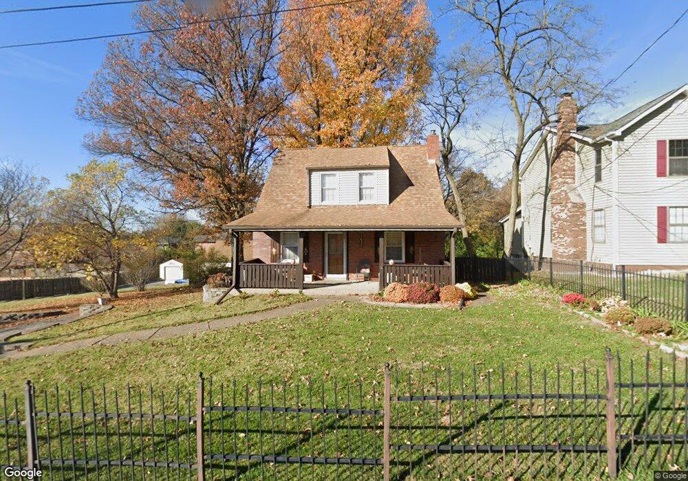
2635 Summit Ave Saint Louis, MO 63114
Estimated Value: $242,000 - $321,000
3
Beds
2
Baths
2,205
Sq Ft
$124/Sq Ft
Est. Value
About This Home
This home is located at 2635 Summit Ave, Saint Louis, MO 63114 and is currently estimated at $274,132, approximately $124 per square foot. 2635 Summit Ave is a home located in St. Louis County with nearby schools including Buder Elementary School, Hoech Middle School, and Ritenour Senior High School.
Ownership History
Date
Name
Owned For
Owner Type
Purchase Details
Closed on
Feb 4, 2000
Sold by
Vaughan Mark S and Vaughan Patricia L
Bought by
Coleman Dale N and Coleman Donna K
Current Estimated Value
Home Financials for this Owner
Home Financials are based on the most recent Mortgage that was taken out on this home.
Original Mortgage
$110,000
Outstanding Balance
$35,805
Interest Rate
7.95%
Estimated Equity
$238,327
Create a Home Valuation Report for This Property
The Home Valuation Report is an in-depth analysis detailing your home's value as well as a comparison with similar homes in the area
Home Values in the Area
Average Home Value in this Area
Purchase History
| Date | Buyer | Sale Price | Title Company |
|---|---|---|---|
| Coleman Dale N | $150,000 | Land Title Company |
Source: Public Records
Mortgage History
| Date | Status | Borrower | Loan Amount |
|---|---|---|---|
| Open | Coleman Dale N | $110,000 |
Source: Public Records
Tax History
| Year | Tax Paid | Tax Assessment Tax Assessment Total Assessment is a certain percentage of the fair market value that is determined by local assessors to be the total taxable value of land and additions on the property. | Land | Improvement |
|---|---|---|---|---|
| 2025 | $3,307 | $63,360 | $8,090 | $55,270 |
| 2024 | $3,307 | $40,890 | $5,400 | $35,490 |
| 2023 | $3,244 | $40,890 | $5,400 | $35,490 |
| 2022 | $3,085 | $34,390 | $4,310 | $30,080 |
| 2021 | $3,074 | $34,390 | $4,310 | $30,080 |
| 2020 | $3,014 | $31,370 | $5,000 | $26,370 |
| 2019 | $3,000 | $31,370 | $5,000 | $26,370 |
| 2018 | $3,002 | $28,080 | $4,600 | $23,480 |
| 2016 | $1,622 | $15,260 | $3,840 | $11,420 |
Source: Public Records
Map
Nearby Homes
- 2454 Prouhet Ave
- 10726 Ridge Ave
- 10643 Thorpe Ave
- 2424 Silkwood Dr Unit 14B
- 10651 Thorpe Ave
- 10532 Decker Ave
- 2420 Fowler Ave
- 10518 Briston Ct
- 10510 Briston Ct Unit 1C
- 2627 Bruno Ave
- 10592 Clarendon Ave
- 2326 Hennepin Dr
- 10515 Clarendon Ave
- 10235 Midland Blvd
- 3001 Ashby Rd
- 3005 Ashby Rd
- 10508 Scotland Dr
- 10327 Eaglewood Ave
- 10609 Lochness Ct
- 10201 Midland Blvd
- 2701 Summit Ave
- 2702 Summit Ave
- 2703 Summit Ave
- 2704 Summit Ave
- 10562 Homestead Ave
- 2540 Bellecote Ave
- 2800 Bruno Ave
- 10571 Homestead Ave
- 10560 Homestead Ave
- 10655 Bruno Ave
- 10567 Homestead Ave
- 10550 Homestead Ave
- 10563 Homestead Ave
- 10638 Ridge Ave
- 10559 Homestead Ave
- 10699 Bruno Ave
- 10699R Bruno Ave
- 10545 Emerald Ridge Ave
- 10650 Ridge Ave
- 10555 Homestead Ave
Your Personal Tour Guide
Ask me questions while you tour the home.