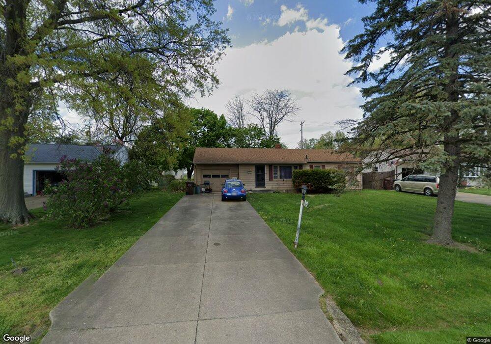
2687 Rhoadesdale Ave Akron, OH 44312
Ellet NeighborhoodEstimated Value: $107,000 - $169,000
About This Home
This home is located at 2687 Rhoadesdale Ave, Akron, OH 44312 and is currently estimated at $145,498, approximately $124 per square foot. 2687 Rhoadesdale Ave is a home located in Summit County with nearby schools including Springfield High School, Summit Academy Akron Elementary School, and Hatton Community Learning Center.
Ownership History
We collect this data history from publicly available records. To have your information removed, we recommend requesting removal directly through your county’s website.
Purchase Details
Home Financials for this Owner
Home Financials are based on the most recent Mortgage that was taken out on this home.Home Values in the Area
Average Home Value in this Area
Purchase History
We collect this data history from publicly available records. To have your information removed, we recommend requesting removal directly through your county’s website.
| Date | Buyer | Sale Price | Title Company |
|---|---|---|---|
| $105,000 | None Listed On Document |
Mortgage History
We collect this data history from publicly available records. To have your information removed, we recommend requesting removal directly through your county’s website.
| Date | Status | Borrower | Loan Amount |
|---|---|---|---|
| Open | $99,750 |
Tax History
We collect this data history from publicly available records. To have your information removed, we recommend requesting removal directly through your county’s website.
| Year | Tax Paid | Tax Assessment Tax Assessment Total Assessment is a certain percentage of the fair market value that is determined by local assessors to be the total taxable value of land and additions on the property. | Land | Improvement |
|---|---|---|---|---|
| 2026 | $4,279 | $45,879 | $8,320 | $37,559 |
| 2024 | $2,650 | $45,879 | $8,320 | $37,559 |
| 2023 | $2,650 | $45,879 | $8,320 | $37,559 |
| 2022 | $2,211 | $33,005 | $5,985 | $27,020 |
| 2021 | $2,166 | $33,005 | $5,985 | $27,020 |
| 2020 | $2,136 | $33,010 | $5,990 | $27,020 |
| 2019 | $1,682 | $22,840 | $6,950 | $15,890 |
| 2018 | $1,550 | $22,840 | $6,950 | $15,890 |
| 2017 | $1,579 | $22,840 | $6,950 | $15,890 |
| 2016 | $1,593 | $22,360 | $6,950 | $15,410 |
| 2015 | $1,579 | $22,360 | $6,950 | $15,410 |
| 2014 | $1,560 | $22,360 | $6,950 | $15,410 |
| 2013 | $1,575 | $22,480 | $6,950 | $15,530 |
Map
- 671 Stevenson Ave
- 643 Stevenson Ave
- 642 Alta Vista Ave
- 484 Stull Ave
- 400 Ripley Ave
- 403 High Grove Blvd
- 916 Abington Rd
- 2645 North Way
- 2809 McElwain Rd
- 391 Alpha Ave
- 359 High Grove Blvd
- 412 Stevenson Ave
- 359 Alpha Ave
- 2904 Pepper Hill Cir
- 404 Wirth Ave
- 2615 Leland Ave
- 1357 Shanafelt Ave
- 2323 Mingo Trail
- 2372 Triplett Blvd
- 2941 Old Home Rd
- 2695 Rhoadesdale Ave
- 2679 Rhoadesdale Ave
- 2701 Rhoadesdale Ave
- 2692 Rhoadesdale Ave
- 2698 Rhoadesdale Ave
- 2671 Rhoadesdale Ave
- 648 Alpha Ave
- 2686 Rhoadesdale Ave
- 2704 Rhoadesdale Ave
- 2711 Rhoadesdale Ave
- 638 Alpha Ave
- 645 Alpha Ave
- 2674 Rhoadesdale Ave
- 641 High Grove Blvd
- 639 Alpha Ave
- 2718 Rhoadesdale Ave
- 2719 Rhoadesdale Ave
- 2661 Rhoadesdale Ave
- 633 Alpha Ave
- 631 High Grove Blvd
Ask me questions while you tour the home.