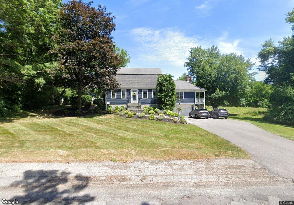
27 Indian Path Rd Halifax, MA 02338
Estimated Value: $653,878 - $794,000
3
Beds
2
Baths
2,246
Sq Ft
$316/Sq Ft
Est. Value
About This Home
This home is located at 27 Indian Path Rd, Halifax, MA 02338 and is currently estimated at $710,220, approximately $316 per square foot. 27 Indian Path Rd is a home located in Plymouth County with nearby schools including Silver Lake Regional High School, Halifax Elementary School, and Silver Lake Regional Middle School.
Ownership History
Date
Name
Owned For
Owner Type
Purchase Details
Closed on
Dec 19, 2013
Sold by
Mcmanus Dennis F and Mcmanus Constance
Bought by
Mcmanus Ft
Current Estimated Value
Purchase Details
Closed on
Jun 5, 1981
Bought by
Mcmanus Dennis F and Mcmanus Constanc
Create a Home Valuation Report for This Property
The Home Valuation Report is an in-depth analysis detailing your home's value as well as a comparison with similar homes in the area
Home Values in the Area
Average Home Value in this Area
Purchase History
| Date | Buyer | Sale Price | Title Company |
|---|---|---|---|
| Mcmanus Ft | -- | -- | |
| Mcmanus Dennis F | -- | -- |
Source: Public Records
Mortgage History
| Date | Status | Borrower | Loan Amount |
|---|---|---|---|
| Previous Owner | Mcmanus Dennis F | $316,000 | |
| Previous Owner | Mcmanus Dennis F | $143,000 |
Source: Public Records
Tax History
| Year | Tax Paid | Tax Assessment Tax Assessment Total Assessment is a certain percentage of the fair market value that is determined by local assessors to be the total taxable value of land and additions on the property. | Land | Improvement |
|---|---|---|---|---|
| 2025 | $8,523 | $597,300 | $200,300 | $397,000 |
| 2024 | $8,355 | $580,200 | $192,600 | $387,600 |
| 2023 | $8,171 | $549,100 | $187,000 | $362,100 |
| 2022 | $7,874 | $491,800 | $167,000 | $324,800 |
| 2021 | $7,746 | $445,400 | $160,500 | $284,900 |
| 2020 | $7,435 | $426,300 | $160,500 | $265,800 |
| 2019 | $7,240 | $414,400 | $155,900 | $258,500 |
| 2018 | $6,915 | $391,800 | $147,100 | $244,700 |
| 2017 | $6,930 | $374,000 | $147,100 | $226,900 |
| 2016 | $6,788 | $352,600 | $137,500 | $215,100 |
| 2015 | $6,599 | $347,500 | $137,500 | $210,000 |
Source: Public Records
Map
Nearby Homes
- 2 Country Club Dr
- 266 Monponsett St Unit 1103
- 266 Monponsett St Unit 1105
- 266 Monponsett St Unit 1201
- 266 Monponsett St Unit 1308
- 266 Monponsett St Unit 1108
- 266 Monponsett St Unit 1101
- 266 Monponsett St Unit 1301
- 266 Monponsett St Unit 302
- 266 Monponsett St Unit 1209
- 8 10th Ave
- 265 Monponsett St Unit 2210
- 265 Monponsett St Unit 2203
- 343 Monponsett St
- 53 Stoney Weir Rd
- 151 Plymouth St Unit 151A
- 8 Beechwood Rd
- 63 Sycamore Dr
- 1 Ferndale Dr
- 21 Parkwood Dr
- 31 Indian Path Rd
- 32 Indian Path Rd
- 32 Indian Path Rd Unit 32
- 35 Indian Path Rd
- 36 Indian Path Rd
- 39 Indian Path Rd
- 40 Indian Path Rd
- 413 Plymouth St
- 43 Indian Path Rd
- 44 Indian Path Rd
- 395 Plymouth St
- 395 Plymouth St Unit 1R
- 395 Plymouth St
- 441 Plymouth St
- 47 Indian Path Rd
- 48 Indian Path Rd
- 363 Plymouth St
- 430 Plymouth St
- 416 Plymouth St
- 385 Plymouth St
Your Personal Tour Guide
Ask me questions while you tour the home.