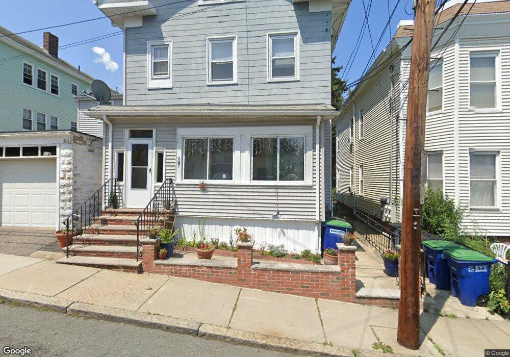
27 Thorpe St Somerville, MA 02143
Prospect Hill NeighborhoodEstimated Value: $1,298,000 - $1,581,000
6
Beds
4
Baths
3,286
Sq Ft
$438/Sq Ft
Est. Value
About This Home
This home is located at 27 Thorpe St, Somerville, MA 02143 and is currently estimated at $1,439,916, approximately $438 per square foot. 27 Thorpe St is a home located in Middlesex County with nearby schools including Somerville High School, Prospect Hill Academy Upper Elementary Campus, and Bright Future Educare Center.
Ownership History
Date
Name
Owned For
Owner Type
Purchase Details
Closed on
Feb 27, 2026
Sold by
Romano Grace
Bought by
Grace Romano Lt and Romano
Current Estimated Value
Purchase Details
Closed on
Mar 14, 2005
Sold by
Romano Grace
Bought by
27 Thorpe St Rt and Romano
Create a Home Valuation Report for This Property
The Home Valuation Report is an in-depth analysis detailing your home's value as well as a comparison with similar homes in the area
Home Values in the Area
Average Home Value in this Area
Purchase History
We collect this data history from publicly available records. To have your information removed, we recommend requesting removal directly through your county’s website.
| Date | Buyer | Sale Price | Title Company |
|---|---|---|---|
| Grace Romano Lt | -- | -- | |
| 27 Thorpe St Rt | -- | -- |
Source: Public Records
Tax History
| Year | Tax Paid | Tax Assessment Tax Assessment Total Assessment is a certain percentage of the fair market value that is determined by local assessors to be the total taxable value of land and additions on the property. | Land | Improvement |
|---|---|---|---|---|
| 2025 | $12,402 | $1,136,800 | $492,400 | $644,400 |
| 2024 | $11,838 | $1,125,300 | $492,400 | $632,900 |
| 2023 | $11,189 | $1,082,100 | $492,400 | $589,700 |
| 2022 | $10,542 | $1,035,600 | $468,900 | $566,700 |
| 2021 | $10,003 | $981,600 | $446,500 | $535,100 |
| 2020 | $9,412 | $932,800 | $429,400 | $503,400 |
| 2019 | $8,661 | $804,900 | $373,400 | $431,500 |
| 2018 | $7,847 | $693,800 | $339,500 | $354,300 |
| 2017 | $7,709 | $660,600 | $320,200 | $340,400 |
| 2016 | $7,554 | $602,900 | $292,900 | $310,000 |
| 2015 | $7,547 | $598,500 | $291,300 | $307,200 |
Source: Public Records
Map
Nearby Homes
- 57 Walnut St Unit 2
- 14 Hamlet St Unit C
- 40 Highland Ave Unit 8
- 82 Munroe St Unit 11
- 46 Highland Ave Unit 3B
- 81 Gilman St
- 109 Walnut St
- 32 Stone Ave
- 27 Prescott St Unit 1
- 142 Cross St
- 232 Pearl St
- 42 Bow St Unit 5
- 76 Flint St Unit 1
- 34 Summer St
- 68 Flint St
- 148 Pearl St
- 300 Somerville Ave
- 197 Washington St Unit 307
- 159 Pearl St
- 373 Somerville Ave Unit D
- 27 Thorpe St Unit 2
- 23 Thorpe St
- 21 Thorpe St
- 25 Thorpe St Unit 1st Floor
- 25 Thorpe St
- 31 Thorpe St
- 61 Walnut St
- 61 Walnut St Unit 2
- 17 Thorpe St
- 63 Walnut St
- 57 Walnut St
- 57 Walnut St Unit 1
- 22 Thorpe St
- 22 Thorpe St Unit 2
- 30 Thorpe St
- 30 Thorpe St
- 30 Thorpe St Unit 2
- 30 Thorpe at Unit 2
- 24 Thorpe St
- 28 Thorpe St
Your Personal Tour Guide
Ask me questions while you tour the home.