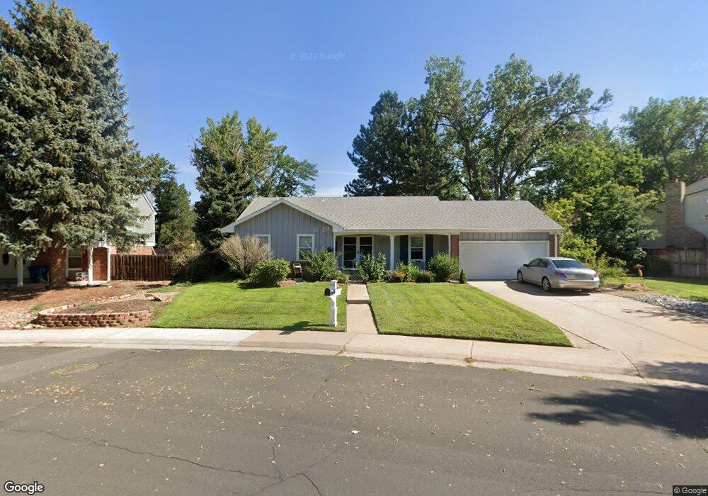
2701 S Macon Cir Aurora, CO 80014
Dam East/West NeighborhoodEstimated Value: $501,269 - $552,000
Studio
3
Baths
1,828
Sq Ft
$289/Sq Ft
Est. Value
About This Home
This home is located at 2701 S Macon Cir, Aurora, CO 80014 and is currently estimated at $528,317, approximately $289 per square foot. 2701 S Macon Cir is a home located in Arapahoe County with nearby schools including Polton Community Elementary School, Prairie Middle School, and Overland High School.
Ownership History
Date
Name
Owned For
Owner Type
Purchase Details
Closed on
Oct 30, 2009
Sold by
Lamb Sarah M and Estate Of Florence M Lamb
Bought by
Luckys Property Management Llc
Current Estimated Value
Purchase Details
Closed on
Jun 29, 1995
Sold by
Whitham Gary J and Whitham Katherine A
Bought by
Lamb Thomas H and Lamb Florence M
Purchase Details
Closed on
Apr 27, 1990
Sold by
Conversion Arapco
Bought by
Whitham Gary J Whitham Katherine A
Purchase Details
Closed on
Jul 4, 1776
Bought by
Conversion Arapco
Create a Home Valuation Report for This Property
The Home Valuation Report is an in-depth analysis detailing your home's value as well as a comparison with similar homes in the area
Home Values in the Area
Average Home Value in this Area
Purchase History
We collect this data history from publicly available records. To have your information removed, we recommend requesting removal directly through your county’s website.
| Date | Buyer | Sale Price | Title Company |
|---|---|---|---|
| Luckys Property Management Llc | -- | None Available | |
| Lamb Thomas H | $145,900 | Commonwealth Land Title | |
| Whitham Gary J Whitham Katherine A | -- | -- | |
| Conversion Arapco | -- | -- |
Source: Public Records
Tax History
| Year | Tax Paid | Tax Assessment Tax Assessment Total Assessment is a certain percentage of the fair market value that is determined by local assessors to be the total taxable value of land and additions on the property. | Land | Improvement |
|---|---|---|---|---|
| 2025 | $2,592 | $32,975 | -- | -- |
| 2024 | $2,276 | $32,904 | -- | -- |
| 2023 | $2,276 | $32,904 | $0 | $0 |
| 2022 | $2,038 | $27,995 | $0 | $0 |
| 2021 | $2,040 | $27,995 | $0 | $0 |
| 2020 | $1,950 | $27,013 | $0 | $0 |
| 2019 | $1,882 | $27,013 | $0 | $0 |
| 2018 | $1,627 | $21,932 | $0 | $0 |
| 2017 | $1,604 | $21,932 | $0 | $0 |
| 2016 | $1,701 | $21,946 | $0 | $0 |
| 2015 | $1,628 | $21,946 | $0 | $0 |
| 2014 | -- | $17,178 | $0 | $0 |
| 2013 | -- | $20,310 | $0 | $0 |
Source: Public Records
Map
Nearby Homes
- 2688 S Macon Ct
- 11184 E Linvale Dr
- 2826 S Lansing Way
- 2889 S Newark Place
- 11467 E Amherst Cir S
- 2884 S Oakland Cir E
- 11132 E Harvard Dr
- 2931 S Lansing Way
- 2933 S Macon St
- 2711 S Oakland Cir E
- 2946 S Moline Place
- 2854 S Kenton Ct
- 11966 E Harvard Ave
- 11925 E Harvard Ave Unit 108
- 3081 S Macon Cir
- 2625 S Peoria St
- 11905 E Harvard Ave Unit 108
- 12083 E Harvard Ave Unit 204
- 11983 E Harvard Ave Unit 106
- 11941 E Cornell Cir
- 11401 E Yale Way
- 2711 S Macon Cir
- 11491 E Yale Way
- 2703 S Macon St
- 2721 S Macon Cir
- 2712 S Macon Cir
- 2689 S Moline Ct
- 11521 E Yale Way
- 11403 E Yale Place
- 2731 S Macon Cir
- 11433 E Yale Place
- 2690 S Moline Ct
- 2742 S Macon Cir
- 2733 S Macon St
- 2697 S Macon Ct
- 11463 E Yale Place
- 2772 S Macon Cir
- 11551 E Yale Way
- 2679 S Moline Ct
- 2741 S Macon Cir
Your Personal Tour Guide
Ask me questions while you tour the home.