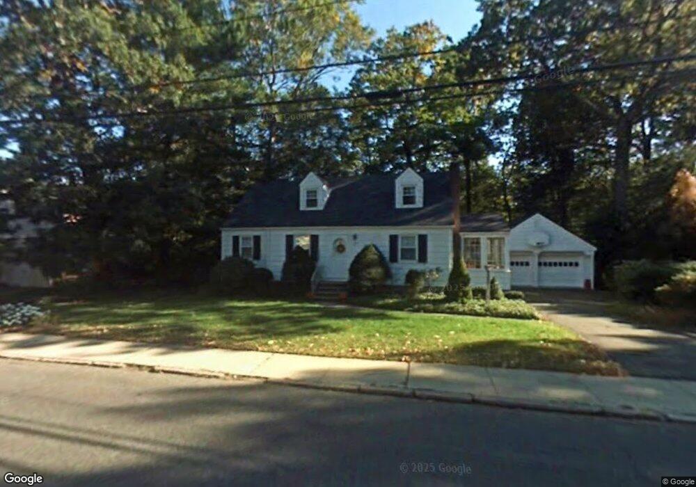
275 Brookside Ave Allendale, NJ 07401
Estimated Value: $769,299 - $890,000
Studio
--
Bath
1,903
Sq Ft
$442/Sq Ft
Est. Value
About This Home
This home is located at 275 Brookside Ave, Allendale, NJ 07401 and is currently estimated at $841,325, approximately $442 per square foot. 275 Brookside Ave is a home located in Bergen County with nearby schools including Hillside Elementary School, Brookside Elementary School, and Northern Highlands Reg High School.
Ownership History
Date
Name
Owned For
Owner Type
Purchase Details
Closed on
May 17, 1996
Sold by
Morrison Hugh
Bought by
Byrnes James and Byrnes Barbara
Current Estimated Value
Home Financials for this Owner
Home Financials are based on the most recent Mortgage that was taken out on this home.
Original Mortgage
$74,000
Outstanding Balance
$4,182
Interest Rate
7.91%
Estimated Equity
$837,143
Create a Home Valuation Report for This Property
The Home Valuation Report is an in-depth analysis detailing your home's value as well as a comparison with similar homes in the area
Home Values in the Area
Average Home Value in this Area
Purchase History
We collect this data history from publicly available records. To have your information removed, we recommend requesting removal directly through your county’s website.
| Date | Buyer | Sale Price | Title Company |
|---|---|---|---|
| Byrnes James | $274,000 | -- |
Source: Public Records
Mortgage History
We collect this data history from publicly available records. To have your information removed, we recommend requesting removal directly through your county’s website.
| Date | Status | Borrower | Loan Amount |
|---|---|---|---|
| Open | Byrnes James | $74,000 |
Source: Public Records
Tax History
| Year | Tax Paid | Tax Assessment Tax Assessment Total Assessment is a certain percentage of the fair market value that is determined by local assessors to be the total taxable value of land and additions on the property. | Land | Improvement |
|---|---|---|---|---|
| 2025 | $11,146 | $553,600 | $319,000 | $234,600 |
| 2024 | $11,338 | $528,500 | $307,000 | $221,500 |
| 2023 | $10,718 | $515,600 | $299,300 | $216,300 |
| 2022 | $10,968 | $481,700 | $275,800 | $205,900 |
| 2021 | $9,768 | $461,300 | $265,100 | $196,200 |
| 2020 | $10,784 | $446,900 | $260,800 | $186,100 |
| 2019 | $10,498 | $446,900 | $260,800 | $186,100 |
| 2018 | $10,265 | $446,900 | $260,800 | $186,100 |
| 2017 | $10,225 | $446,900 | $260,800 | $186,100 |
| 2016 | $10,238 | $446,900 | $260,800 | $186,100 |
| 2015 | $9,783 | $446,900 | $260,800 | $186,100 |
| 2014 | $9,554 | $411,400 | $239,400 | $172,000 |
Source: Public Records
Map
Nearby Homes
- 255 Park Ave
- 112 Edgewood Rd
- 4 Conklin Ct
- 81 Park Ave
- 8 Crestwood Mews
- 218 Orchard Park
- 20 Cambridge Dr
- 77 Myrtle Ave
- 74 van Blarcom Ln
- 314 Meadowbrook Rd
- 56 Longfellow Ln
- 24 Vanderbeck Ln
- 802 Whitney Ln
- 46 van Blarcom Ln
- 114 Crescent Ave
- 113 Macleish Ct
- 22-1 Tamaron Dr
- 16 Sandburg Ct Unit 16
- 81 Chestnut St
- 29 Lindbergh Pkwy
- 279 Brookside Ave
- 271 Brookside Ave
- 293 Brookside Ave
- 270 Brookside Ave
- 268 Brookside Ave
- 280 Brookside Ave
- 262 Brookside Ave
- 299 Brookside Ave
- 32 Carteret Rd
- 250 Brookside Ave
- 30 Carteret Rd
- 34 Carteret Rd
- 321 Brookside Ave
- 49 Donny Brook Dr
- 240 Brookside Ave
- 36 Carteret Rd
- 323 Brookside Ave
- 40 Donny Brook Dr
- 310 Brookside Ave
- 234 Brookside Ave
Your Personal Tour Guide
Ask me questions while you tour the home.