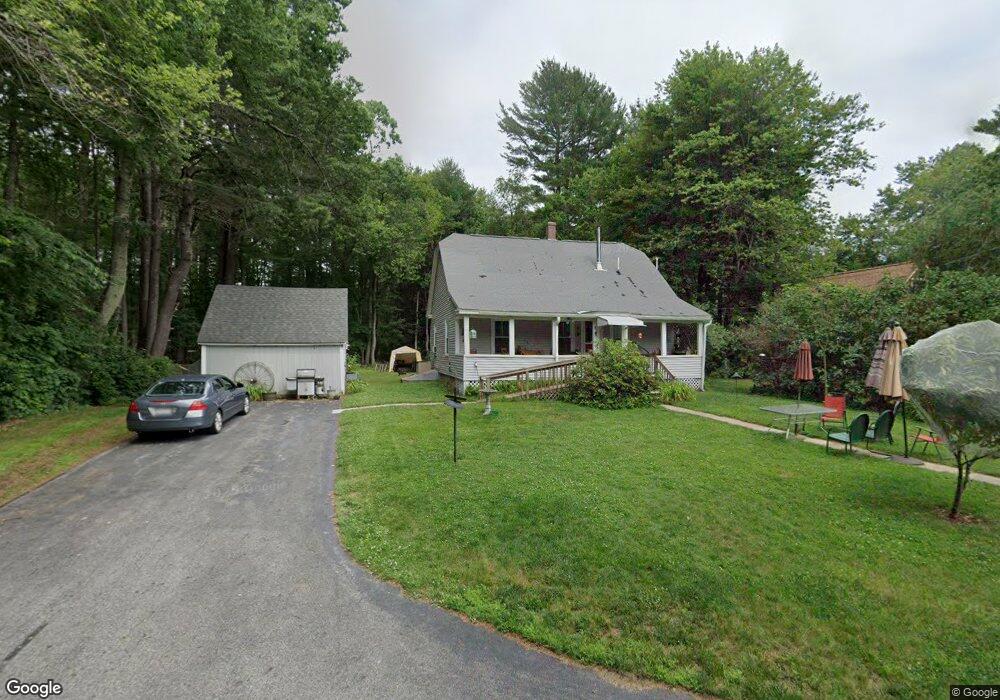
28 Labbe Rd Groton, MA 01450
Estimated Value: $456,003 - $598,000
2
Beds
1
Bath
1,764
Sq Ft
$308/Sq Ft
Est. Value
About This Home
This home is located at 28 Labbe Rd, Groton, MA 01450 and is currently estimated at $544,001, approximately $308 per square foot. 28 Labbe Rd is a home located in Middlesex County with nearby schools including Groton Dunstable Regional High School and Groton Community School.
Ownership History
Date
Name
Owned For
Owner Type
Purchase Details
Closed on
Aug 27, 2023
Sold by
Pietras Philip G and Pietras Kathleen F
Bought by
Pietras Ryan A
Current Estimated Value
Purchase Details
Closed on
May 6, 2010
Sold by
Pietras John A and Pietras Georgette C
Bought by
Pietras Phillip and Pietras Kathleen
Purchase Details
Closed on
Feb 6, 1963
Bought by
Pietras Philip
Create a Home Valuation Report for This Property
The Home Valuation Report is an in-depth analysis detailing your home's value as well as a comparison with similar homes in the area
Home Values in the Area
Average Home Value in this Area
Purchase History
| Date | Buyer | Sale Price | Title Company |
|---|---|---|---|
| Pietras Ryan A | -- | None Available | |
| Pietras Ryan A | -- | None Available | |
| Pietras Ryan A | -- | None Available | |
| Pietras Philip G | -- | None Available | |
| Pietras Philip G | -- | None Available | |
| Pietras Phillip | -- | -- | |
| Pietras Phillip | -- | -- | |
| Pietras Philip | -- | -- |
Source: Public Records
Tax History
| Year | Tax Paid | Tax Assessment Tax Assessment Total Assessment is a certain percentage of the fair market value that is determined by local assessors to be the total taxable value of land and additions on the property. | Land | Improvement |
|---|---|---|---|---|
| 2025 | $5,620 | $368,500 | $170,700 | $197,800 |
| 2024 | $5,153 | $341,500 | $170,700 | $170,800 |
| 2023 | $5,149 | $329,200 | $170,700 | $158,500 |
| 2022 | $5,152 | $299,700 | $153,100 | $146,600 |
| 2021 | $4,882 | $277,400 | $145,600 | $131,800 |
| 2020 | $4,533 | $260,800 | $145,600 | $115,200 |
| 2019 | $4,549 | $251,200 | $138,700 | $112,500 |
| 2018 | $4,412 | $236,300 | $138,700 | $97,600 |
| 2017 | $4,231 | $231,700 | $138,700 | $93,000 |
| 2016 | $4,323 | $230,200 | $141,900 | $88,300 |
| 2015 | $4,206 | $230,200 | $141,900 | $88,300 |
Source: Public Records
Map
Nearby Homes
- 15 Gilson Rd
- Lot 2 Monarch Path
- Lot 1 Monarch Path
- 59 Hidden Valley Rd
- 1 Little Hollow Ln
- 6 Little Hollow Ln
- 176 Whiley Rd
- 797 Boston Rd
- 34 West St
- 2 Macquarrie Ln
- 14 Island Rd
- 5 Maura Cir
- 82 Pleasant St
- 10 Laurel Ln
- 3 Cheyenne Valley Unit 3
- 23 Apache Way Unit 23
- 20 Bayberry Rd
- 76 Beaver Brook Rd
- 3 Hillside Ave
- 76 Robin Hill Rd
- 24 Labbe Rd
- 23 Labbe Rd
- 15f Brookfield Dr Unit 15F
- 70 Hayden Rd
- 15 Brookfield Dr Unit C
- 15 Brookfield Dr Unit A
- 27d Brookfield Dr Unit D
- 12B Brookfield Dr Unit 12B
- 12A Brookfield Dr Unit 1
- 16C Brookfield Dr Unit C
- 16E Brookfield Dr Unit E
- 16D Brookfield Dr Unit 16
- 33B Brookfield Dr Unit 33B
- 16E Brookfield Dr
- 12D Brookfield Dr Unit 12D
- 33E Brookfield Dr Unit 33,E
- 5A Brookfield Dr Unit A5
- 15C Brookfield Dr Unit 15
- 12F Brookfield Dr Unit 12F
- 29B Brookfield Dr Unit 29
Your Personal Tour Guide
Ask me questions while you tour the home.