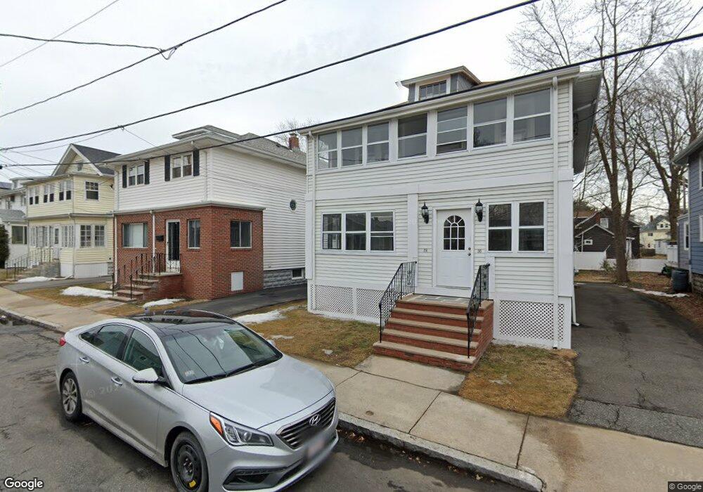
28 Maple Ave Medford, MA 02155
Medford Hillside NeighborhoodEstimated Value: $842,793 - $1,058,000
4
Beds
2
Baths
1,898
Sq Ft
$513/Sq Ft
Est. Value
About This Home
This home is located at 28 Maple Ave, Medford, MA 02155 and is currently estimated at $973,948, approximately $513 per square foot. 28 Maple Ave is a home located in Middlesex County with nearby schools including Medford High School, St. Joseph School, and Saint Raphael School.
Ownership History
Date
Name
Owned For
Owner Type
Purchase Details
Closed on
Mar 21, 2024
Sold by
28-30 Maple Avenue Rt and Govostes
Bought by
Ferrante Linda and Govostes William G
Current Estimated Value
Purchase Details
Closed on
Feb 12, 2014
Sold by
Sophie Govostes Ret and Govostes
Bought by
28-30 Maple Avenue Rt and Govostes
Purchase Details
Closed on
Jan 9, 2009
Sold by
Govostes Sophia
Bought by
Sophia Govostes Ret and Govostes
Create a Home Valuation Report for This Property
The Home Valuation Report is an in-depth analysis detailing your home's value as well as a comparison with similar homes in the area
Home Values in the Area
Average Home Value in this Area
Purchase History
| Date | Buyer | Sale Price | Title Company |
|---|---|---|---|
| Ferrante Linda | -- | None Available | |
| 28-30 Maple Avenue Rt | -- | -- | |
| Sophia Govostes Ret | -- | -- |
Source: Public Records
Tax History
| Year | Tax Paid | Tax Assessment Tax Assessment Total Assessment is a certain percentage of the fair market value that is determined by local assessors to be the total taxable value of land and additions on the property. | Land | Improvement |
|---|---|---|---|---|
| 2025 | $7,386 | $839,300 | $423,300 | $416,000 |
| 2024 | $6,627 | $777,800 | $383,900 | $393,900 |
| 2023 | $6,451 | $745,800 | $358,800 | $387,000 |
| 2022 | $6,426 | $713,200 | $326,200 | $387,000 |
| 2021 | $6,097 | $647,900 | $310,600 | $337,300 |
| 2020 | $6,072 | $661,400 | $318,600 | $342,800 |
| 2019 | $5,779 | $602,000 | $289,600 | $312,400 |
| 2018 | $5,514 | $538,500 | $263,300 | $275,200 |
| 2017 | $5,198 | $492,200 | $246,000 | $246,200 |
| 2016 | $5,058 | $452,000 | $223,700 | $228,300 |
| 2015 | $4,908 | $419,500 | $213,100 | $206,400 |
Source: Public Records
Map
Nearby Homes
- 17 Manning St
- 4 West St
- 54 South St Unit 5
- 2500 Mystic Valley Pkwy Unit 401
- 235 Winthrop St Unit 4401
- 22 Martin St Unit 22
- 190 High St Unit 412
- 161 Main St
- 52 Greenleaf Ave
- 168 Main St
- 179 Main St Unit 1
- 21 Bradlee Rd Unit 32
- 21 Bradlee Rd Unit 52
- 72 College Ave
- 75 Orchard St
- 34 Salem St Unit 301
- 32 Lincoln Rd
- 54 Forest St Unit 320
- 54 Forest St Unit 411
- 48 Forest St Unit 201
- 28 Maple Ave
- 28 Maple Ave Unit 1
- 30 Maple Ave Unit 2
- 26 Maple Ave
- 26 Maple Ave Unit 1
- 32 Maple Ave
- 32 Maple Ave Unit 1
- 34 Maple Ave
- 34 Maple Ave Unit Upstairs-34A
- 22 Maple Ave
- 27 Maple Ave
- 31 Maple Ave Unit 2
- 25 Maple Ave
- 20 Maple Ave
- 20 Maple Ave Unit 2
- 20 Maple Ave Unit 1
- 29 Maple Ave
- 36 Maple Ave
- 33 Touro Ave
- 27 Touro Ave
Your Personal Tour Guide
Ask me questions while you tour the home.